Aigai (Aeolis): An Ancient Aeolian City in Modern Turkey
: An Ancient Aeolian City in Modern Turkey 6")
: An Ancient Aeolian City in Modern Turkey 7")
: An Ancient Aeolian City in Modern Turkey 8")
: An Ancient Aeolian City in Modern Turkey 9")
: An Ancient Aeolian City in Modern Turkey 10")
Visitor Information
Google Rating: 4.6
Popularity: Low
Google Maps: View on Google Maps
Official Website: www.aigai.info
Country: Turkey
Civilization: Byzantine, Greek, Roman
Remains: City

History
Aigai (Aeolis) Ancient City lies within the boundaries of Merkez municipality in modern-day Turkey and was established by the Aeolian Greeks. The city emerged following migration movements into northwest Anatolia, with archaeological data dating its foundation not earlier than the late 8th century BCE, despite traditional beliefs placing it shortly after 1100 BCE. Positioned atop Gün Dağı in the Yunt Mountains, Aigai became one of the twelve members of the Aeolian dodecapolis, a federation of cities sharing cultural and linguistic ties.
During the 6th century BCE, specifically after 547 BCE, Aigai resisted the expansion of Persian control along with nearby Temnos, indicating a degree of local autonomy. Unlike many cities in the region, Aigai did not contribute taxes or tribute to the Delian League during the 5th century BCE. The settlement maintained a modest size until the early Hellenistic period. Around the early 3rd century BCE, development accelerated markedly under Filetairos, the founder of the Kingdom of Pergamon. His patronage transformed the city into a vibrant urban center with characteristics typical of Hellenistic design and civic planning.
Throughout the 3rd century BCE, Aigai experienced shifts in political control between the Kingdom of Pergamon and the Seleucid Empire. Eventually, the city returned definitively to Pergamon governance under Attalus I by 218 BCE. Conflict continued in 156 BCE when Prusias II of Bithynia destroyed the city during a war. Following Roman arbitration, the city was compensated with 100 talents, demonstrating early Roman involvement in the region’s affairs.
Under Roman dominion from 129 BCE onward, Aigai benefited from patronage by Roman officials, most notably Publius Servilius Isauricus, the governor of the Roman province of Asia between 48 and 46 BCE. His support notably extended to the Apollon Khresterios Temple. A major earthquake in 17 CE caused widespread destruction, yet Emperor Tiberius provided funds for the city’s restoration, signaling its continued importance.
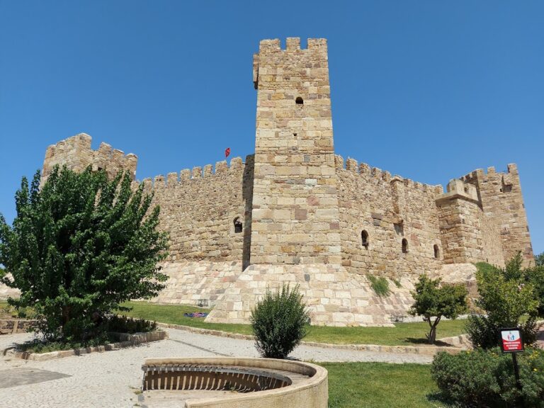
The last historical mentions of Aigai come from ecclesiastical records in the 5th century CE. It probably faced abandonment by the 7th century CE in response to Arab raids that disrupted the wider region. Centuries later, during the Byzantine era in the 12th to 13th centuries CE, a small fortress and associated settlement occupied the site, though this presence ended by the late 14th century following Turkish conquests.
Archaeological interest in Aigai began in 1881 with French research teams, and systematic excavations have resumed since 2004 under the leadership of experts from Turkish universities.
Remains
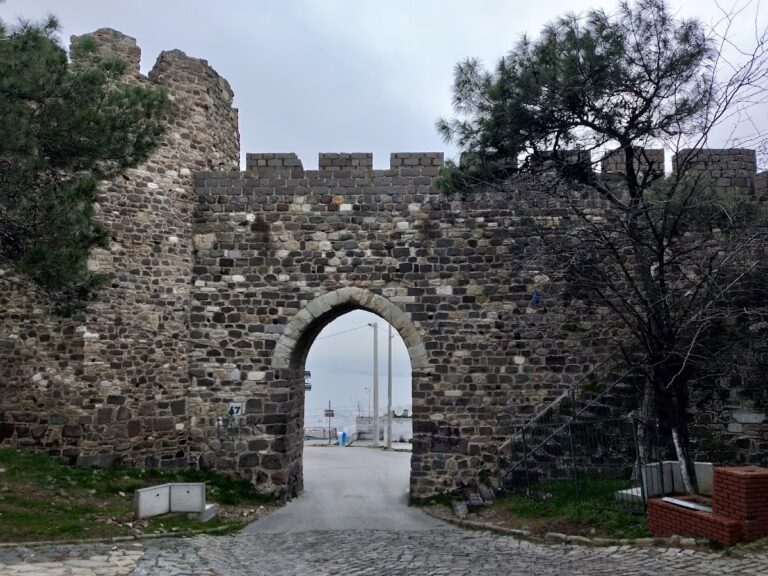
Aigai rests on a plateau at an elevation of 365 meters atop Gün Dağı, surrounded by extensive fortifications measuring roughly 1.5 kilometers in length. These defensive walls consist of robust stone masonry arranged in multi-angled and rectangular formations set in two tiers. The inner fortification encloses a roughly triangular area stretching about one kilometer, with sections climbing significantly in terrain elevation, creating a formidable defensive position.
Among the city’s public spaces, the Hellenistic market hall, or macellum, stands out as a three-story structure approximately 82 meters long and 11 meters tall. It contains sixteen pairs of adjacent shops on the ground floor facing east, while additional chambers occupy the upper levels. Efforts are underway to restore its facade using original stones found on site, preserving its architectural presence.
The city’s agora, or public square, includes important civic buildings such as a bouleuterion, serving as a council house, and an odeon used for musical and theatrical performances. An intricate water management system channels rainwater away from paved streets into numerous cisterns below, demonstrating advanced urban infrastructure. Archaeologists have uncovered water pipes and drainage features that exemplify this system.
On the northwest slope near the theater’s terrace stands a temple dedicated to Demeter and Kore, dated to the late 3rd or early 2nd century BCE. This Doric-style ante temple, constructed of trachyte stone, is oriented north-south with its main entrance southward, facing both the theater and the agora. The temple measures roughly 9.7 by 6.7 meters. Its nearly square inner chamber, or cella, is about 5.2 meters per side, preceded by a pronaos (porch) 3.12 meters deep. The columns, set with generous spacing (diastylos), consist of three stone drums each, standing approximately 4.33 meters including capitals. The column bases taper from a diameter of 0.57 meters to 0.455 meters. A distinctive tetrastyle (four-column) design with metopes (decorative panels) completes its Doric character. Although trachyte stone weathers readily, significant remains including inscriptions survive.
Further within the urban area, a gymnasium and a stadium attest to the city’s organized athletic life. The baths contain a frigidarium (cold room) featuring a mosaic from the 3rd or 4th century BCE depicting Poseidon, accompanied by a Greek inscription that welcomes visitors. A marble inscription dated to the 2nd century CE, found in the bouleuterion, records complaints about Roman tax officials and describes a taxation system involving goat skins, revealing details about local economic concerns under Roman rule.
The Apollon Khresterios Temple, located about five kilometers east near a river, reflects Roman-era architectural influences with support from Pergamene authorities around 46 BCE during the governorship of Publius Servilius Isauricus. It follows an Ionic peripteros style—an Ionic temple surrounded by a single row of columns—with a cella reaching six meters in height. Three monoliths of these columns remain standing, offering a glimpse of its former grandeur.
The theater, situated to the south of the Demeter-Kore Temple, preserves vaulted corridors beneath the seating areas, a typical feature of Greek theaters to provide structural support and audience access. South of the theater lies the stadium, completing the city’s athletic complexes.
Numismatic evidence from coinage minted in Aigai bears images of deities and symbols such as Apollo, goats, Athena, and Nike, reflecting religious affiliations and local identity.
Overall, the city walls and terraced constructions remain visible on the landscape. While many foundations and scattered ruins have become overgrown, key architectural elements such as the market hall rise as imposing remnants, and ongoing preservation efforts seek to maintain these traces of Aigai’s diverse historical phases.
Nearby sites