Pergamon Ancient City: A Hellenistic and Roman Cultural Centre in Turkey


Site at a Glance
- Rating
- 4.7
- Popularity
- Medium
- Country
- Turkey
- Primary era
- Classical
- External website
- Open
- Eras represented
- Classical, Medieval
- Civilizations
- Ancient Greek, Byzantine, Roman
- Site type
- City
On this page29 sections
History
Pergamon Ancient City is the remains of a Greek and Roman city at Bergama in Turkey, centred on a 335-metre-high acropolis in northwestern Anatolia. Its settlement history reaches back to the Archaic period, while its most influential phase came under the Hellenistic Attalid dynasty, when Pergamon became a powerful kingdom, a major artistic centre, and a city rebuilt on a monumental scale.
Early settlement and Persian rule
Pergamon stood in Aeolis, in the historic region of Mysia, on the northern edge of the Caicus plain. The city lay about 26 kilometres from the Aegean coast, with the port of Elaia serving as its maritime outlet. Archaeological evidence places settlement on the site during the Archaic period, especially through imported eastern Greek and Corinthian pottery dating from the late eighth century BC. Bronze Age stone tools have been found in the surrounding area, although a Bronze Age settlement at Pergamon itself has not been demonstrated.
The city first enters literary history in connection with the end of Xenophon’s march of the Ten Thousand in 400/399 BC. In March 399 BC, Xenophon handed about 5,000 surviving Greek soldiers to Thibron, who was preparing a campaign against the Persian satraps Tissaphernes and Pharnabazus. Pergamon then belonged to the family of Gongylos of Eretria, whose widow Hellas hosted Xenophon. In 362 BC, Orontes, the Persian satrap of Mysia, used the city as a base for an unsuccessful revolt against Persia. Pergamon and its surrounding territory passed from Persian control during the conquests of Alexander the Great.
Much of the fourth-century BC city was later altered or removed by large-scale terracing. Elements of the Temple of Athena and the walls and altar foundations in the Sanctuary of Demeter nevertheless belong to this period.
The Attalid kingdom
After Alexander’s successors divided his territories, Lysimachus, king of Thrace, took possession of Pergamon in 301 BC and placed it under his lieutenant Philetaerus. Following the collapse of the Thracian kingdom in 281 BC, Philetaerus became an independent ruler and founded the Attalid dynasty. The Attalids, the Hellenistic ruling family whose kingdom was centred on Pergamon, governed the city from 281 to 133 BC.
Philetaerus initially controlled Pergamon and its immediate surroundings. After Eumenes I defeated Antiochus I at Sardis in 261 BC, Pergamene territory expanded towards the coast and inland, although Eumenes did not take a royal title. In 238 BC, Attalus I defeated the Galatians, to whom Pergamon had paid tribute under Eumenes, and declared himself ruler of an independent kingdom.
The Attalids supported Rome during the Macedonian Wars and the Roman-Syrian conflict. After the Peace of Apamea in 188 BC, Pergamon received most of the former Seleucid territories in Asia Minor and reached the greatest territorial extent of its kingdom. Eumenes II continued to support Rome during the Third Macedonian War, but rumours that he had negotiated with Perseus of Macedon caused Rome to deny Pergamon further rewards and to favour his brother Attalus II.
Under Eumenes II and Attalus II, Pergamon reached its political and cultural height. The rulers rebuilt the city as a major centre of Greek art and learning, using monumental architecture, sculpture, religious cults, and dynastic traditions to strengthen their authority. Pergamon retained an earlier urban area of about 21 hectares before a new wall, roughly 4 kilometres long and enclosing about 90 hectares, was built after 188 BC.
The Attalids encouraged urban development by bringing skilled artisans to their territories, remitting taxes, allowing Greek cities nominal independence, and giving gifts to cultural centres such as Delphi, Delos, and Athens. Pergamon also became a major centre of parchment production. Parchment was not invented there, however, and had already been used in Anatolia before the city’s rise.
From the Roman province to late antiquity
When Attalus III died without an heir in 133 BC, he bequeathed Pergamon to Rome. Aristonicus, who claimed to be the king’s brother, led an armed revolt with the support of the Stoic philosopher Blossius. The Roman consul Marcus Perperna defeated him in 129 BC. The Attalid kingdom was then divided among Rome, Pontus, and Cappadocia, while most of its territory became the Roman province of Asia. Pergamon was declared a free city and briefly served as the provincial capital before that distinction passed to Ephesus.
In 88 BC, Mithridates VI Eupator used Pergamon as his headquarters during his first war against Rome. After his defeat, Rome removed the city’s privileges and free-city status. Pergamon paid tribute, housed and supplied Roman troops, and suffered confiscations of property. Diodorus Pasparus, a member of the Pergamene aristocracy, used his wealth and diplomatic influence in the 70s BC to support the city and reduce some of its new burdens. Honorific inscriptions preserve his exceptional public position.
Pergamon remained a major city under Roman rule. It was the seat of a conventus, a regional judicial assembly, and an important centre of the imperial cult, the Roman system of publicly honouring and worshipping the emperor and imperial household. Augustus granted Pergamon a neocorate, an official privilege to maintain a temple and cult of the emperor. Trajan granted a second in AD 113/114, and Caracalla granted a third in the early third century. Hadrian raised the city to metropolitan rank in AD 123, placing it above the regional rivals Ephesus and Smyrna.
Under Trajan and his successors, a Roman new city was planned at the foot of the acropolis. Temples, a stadium, theatres, a forum, an amphitheatre, baths, and sanctuaries were constructed. The Sanctuary of Asclepius was expanded into an internationally renowned healing centre. Pergamon had about 200,000 inhabitants in the middle of the second century AD and was one of the largest cities in the province. Galen was born there and received his early training at the Asclepieion, a sanctuary where worship of Asclepius, bathing, dream interpretation, dedications, and medical treatment were combined.
Economic decline began during the third century. An earthquake badly damaged the city in AD 262, and the Goths sacked it soon afterwards. Late antiquity brought only limited economic recovery. The Asklepios cult, established at Pergamon by the fourth century BC and initially associated with the family of its reputed founder Archias, had become a state cult under Eumenes II.
Byzantine, Seljuk, and Ottoman periods
Arab raids first captured Pergamon in AD 663/664. Settlement contracted to the acropolis, which Emperor Constans II protected with a wall about 6 metres thick built from reused architectural material. The city was raided again in 716 by the forces of Maslama ibn Abd al-Malik. After the Arabs abandoned their siege of Constantinople in 717-718, Pergamon was rebuilt and refortified.
During the middle Byzantine period, Pergamon belonged to the Thracesian Theme, a Byzantine military and administrative district, and from the reign of Leo VI to the Theme of Samos. Seventh-century evidence records an Armenian community, probably formed by refugees from the Muslim conquests. This community produced the emperor Philippicus.
Following the Seljuk advance into western Anatolia after the Battle of Manzikert in 1071, Pergamon suffered further attacks. The assaults of 1109 and 1113 largely destroyed the city. Emperor Manuel I Komnenos rebuilt it around 1170, and it probably became the capital of the Theme of Neokastra. Under Isaac II Angelos, its ecclesiastical see was promoted from a suffragan diocese of Ephesus to a metropolitan bishopric.
After the capture of Constantinople in 1204 during the Fourth Crusade, Pergamon became part of the Empire of Nicaea. When Emperor Theodore II Laskaris visited around 1250, the theatre had already been destroyed and the Attalid and Roman monuments stood as plundered ruins. The walls and the vaulted structures over the Selinus River attracted particular attention.
Pergamon fell to the Karasids shortly after 1300 and was later conquered by the Ottoman beylik. Ephesus assumed its metropolitan status by 1387, and the city disappeared from the records by the fifteenth century. In the sixteenth century, Sultan Murad III ordered two large alabaster urns from the ruins to be transported to Hagia Sophia in Istanbul.
Myths, rediscovery, and archaeology
Pergamon was associated with foundation traditions centred on heroic ancestry. One linked the city with Telephus, the son of Heracles. Another attributed its name to Pergamus, supposedly a grandson of Achilles through Neoptolemus and Andromache. These traditions are not attested before the third century BC and were developed or adopted late, particularly under the Attalids, who used descent from Heracles to strengthen dynastic prestige. Pergamenes called themselves Telephidai and referred poetically to their city as the Telephian city.
Pergamenes sacrificed to Telephus, and the supposed grave of his mother Auge was placed near the Caicus. From the Roman period, Pergamus appeared on civic coinage and was said to have possessed a heroon, a shrine or monument associated with a hero. Mithridates VI was celebrated at Pergamon as a new Pergamus.
The first post-antique written references to Pergamon date from the thirteenth century. From the fifteenth century, travellers including Ciriaco de’ Pizzicolli described the site. Thomas Smith produced an important detailed account after visiting in 1668, followed by accounts from Jacob Spon and George Wheler. During the late eighteenth and early nineteenth centuries, Marie-Gabriel-Florent-Auguste de Choiseul-Gouffier, Charles Robert Cockerell, Otto Magnus von Stackelberg, and Charles Texier documented the city and its ruins.
Carl Humann first visited Pergamon in 1864-1865 while involved in planning the road to Dikili. He returned in 1869, organized an expedition under Ernst Curtius in 1871, and helped initiate systematic investigation. The expedition discovered two fragments of a large frieze, although their connection with the Great Altar was initially uncertain.
Alexander Conze began a programme of excavation and protection after taking charge of the ancient sculpture department of the Royal Museums in Berlin. Humann, who discovered the architrave inscription of the Temple of Demeter in 1875, excavated the area of the Zeus Altar from 1878 to 1886. With Ottoman approval, the excavated reliefs were transferred to Berlin, where the first Pergamon Museum opened in 1907.
Wilhelm Dörpfeld directed important work from 1900 to 1911, exposing the Lower Agora, House of Attalos, Gymnasium, and Sanctuary of Demeter. Excavations were interrupted by the First World War and resumed in 1927 under Theodor Wiegand, who worked on the Upper City, the Asclepieion, and the Red Basilica until 1939. Research stopped again during the Second World War and resumed in 1957. Erich Boehringer worked especially at the Asclepieion from 1957 to 1968, while Wolfgang Radt, from 1971, concentrated on residential buildings, water management, and conservation. Since 2006, excavations have been led by Felix Pirson.
Most finds excavated before the First World War were taken to the Pergamon Museum in Berlin, while a smaller portion went to the Istanbul Archaeological Museum. The Bergama Museum, opened after the First World War, received finds discovered thereafter. In May 2022, archaeologists announced a well-preserved geometric floor mosaic approximately 1,800 years old near the Red Basilica. Pergamon and its multilayered cultural landscape were inscribed on the UNESCO World Heritage List in 2014 under cultural criteria i, ii, iii, iv, and vi. The listed area covers 332.5 hectares, with a 476.9-hectare buffer zone.
Remains
Acropolis setting and urban layout
Pergamon occupies an andesite mesa forming the acropolis. The massif is about 1 kilometre wide and extends 5.5 kilometres from north to south. It has a broad base, a relatively small upper city, steep drops to the north, east, and west, and three natural terraces approaching from the south. The Selinus River, now the Bergamaçay, runs west of the acropolis, while the Cetius, now the Kestelçay, passes to the east. The city developed across the acropolis, its slopes, and the plain below.
Walls, gates, and streets
Philetaerus transformed the earlier settlement into a fortified city. The first major enclosure covered the upper city, the southern plateau, the Upper Agora, and part of the housing. Under Eumenes II and Attalus II, a new wall extended around the hill and included the southwestern flat area as far as the Selinus. It had numerous gates, including the monumental Gate of Eumenes. Public buildings, a new marketplace south of the acropolis, and a gymnasium east of it were added as the southeastern and western slopes were opened by streets.
The steep ground required streets to follow hairpin turns, while rock cutting and terraces created platforms for buildings and agoras. The principal road climbed towards the acropolis, with shops and warehouses along its course. Its surface used andesite blocks as much as 5 metres wide, 1 metre long, and 30 centimetres deep, with drainage channels carrying water down the slope. Pergamon distinguished broad avenues, or plateiai, from narrower connecting streets, or stenopoi. Around the gymnasium, streets up to 4 metres wide may have followed a fan-shaped plan.
Housing and water supply
Hellenistic houses generally formed small, roughly square courtyards with rooms on one or two sides. Important rooms often occupied two levels on the northern side, while passages or colonnades opened towards the courtyard. Some were Prostas houses, while others had broad columned halls and upper stories reached by stairs. Cisterns in the courtyards collected rainwater from sloping roofs. Residential blocks built under Eumenes II can be reconstructed at about 35 by 45 metres, although the terrain caused their dimensions to vary.
The water system combined cisterns with nine conduits, including seven Hellenistic ceramic-pipe lines and two open Roman channels. It supplied approximately 30,000-35,000 cubic metres of water per day. The Hellenistic Madradağ aqueduct carried water through an 18-centimetre-diameter ceramic pipe from a spring more than 40 kilometres away in the Madradağ mountains. Three channels ended at a basin about 3 kilometres north of the citadel. From there, a lead pressure pipe crossed a valley roughly 200 metres deep and raised water to the acropolis through communicating vessels.
Marketplaces and civic buildings
Upper Agora
The Upper Agora developed south of the acropolis. Attalus I built a Temple of Zeus there, followed by a multistorey building probably linked with the market. Halls constructed under Eumenes II contained rear chambers probably used for trade, while a western chamber may have housed market administration. The agora served commercial and representative purposes, particularly after the neighbouring Sanctuary of Athena and Pergamon Altar were redesigned.
Lower Agora
The Lower Agora measured about 55 by 80 metres and was built around 50 BC-AD 50. Its roughly rectangular plan adapted to the slope and included three levels. The upper and main levels opened onto a central courtyard, while rooms on the lower level opened through a colonnade towards the surrounding streets. Andesite construction and the arrangement of the buildings retained forms influenced by the Attalid period.
Foundations show that statue bases and other monuments stood in the central court. The complex was extensively renovated, probably after earthquake damage, around the middle of the second century AD. The northern hall was strengthened with inserted arches. By about the fourth century, surviving structures had been reused for small-scale housing, and in the late fourth or early fifth century a three-aisled church was built over the former central court.
Bridge beneath the Red Basilica
The Selinus passed beneath the western main courtyard of the Red Basilica and was carried below its forecourt by the Pergamon Bridge. Constructed under Hadrian, the bridge substructure is nearly 200 metres long and forms the principal surviving structural support for the complex.
Upper-city sanctuaries and theatre
Pergamon Altar
The Pergamon Altar, probably dedicated to Zeus and Athena, stood on an artificially levelled and terraced platform aligned with the Temple of Athena. Its base measured about 36 by 33 metres. The altar survives on the upper city chiefly through its foundations, while sections of the original reliefs are displayed in partial reconstruction in Berlin.
The outer high-relief frieze portrayed the Gigantomachy, the mythological battle between the Olympian gods and the Giants. It measured 2.30 metres high and 113 metres long. A staircase nearly 20 metres wide cut into the western side led to a colonnaded upper structure and courtyard. The interior walls carried a second frieze, about 1.60 metres high, showing episodes from the life of Telephus.
Theatre and Dionysus terrace
The predominantly Hellenistic Theatre of Pergamon accommodated about 10,000 spectators in 78 rows. Its seating rises approximately 36 metres, and two horizontal walkways divide the auditorium. Stairs 0.75 metres wide divide the lower seating into seven sections and the middle and upper parts into six.
A terrace beneath the theatre extends about 247 metres and reaches 17.4 metres in width. A high retaining wall supports it, while a roofed colonnade, or stoa, frames its long side. The terrace could be entered from the Upper Agora through a tower building at its southern end. Since the restricted space did not allow a circular orchestra, performances used a removable wooden stage until a permanent marble stage building was added in the first century BC. This arrangement preserved the view towards the Temple of Dionysus at the northern end.
Temple of Trajan
The Temple of Trajan, also dedicated to Zeus Philios, occupied the highest point of the citadel. The temple stood on a 2.9-metre-high podium above a vaulted terrace and was an approximately 18-metre-wide Corinthian peripteral temple, meaning that a single external colonnade surrounded it. It had six columns on each short side, nine on each long side, and two rows between the projecting side walls of the porch.
A high northern stoa enclosed the precinct. Ashlar walls initially bounded its eastern and western sides, and these were supplemented or replaced by roofed colonnades under Hadrian. Excavations recovered fragments of statues of Trajan and Hadrian, including portrait heads, as well as parts of the cult statue of Zeus Philios.
Temples, gymnasium, and sacred terraces
Sanctuary of Athena
The Sanctuary of Athena is Pergamon’s oldest temple complex and dates from the fourth century BC. Its north-facing Doric peripteral temple had six columns on the short sides and ten on the long sides. The cella, the enclosed central room, was divided into two chambers. Its foundations measure approximately 12.70 by 21.80 metres and remain visible.
Under Eumenes II, a two-storey stoa was added around three sides of the temple, with a monumental entrance, or propylon, at the southeast corner. The entrance is largely reconstructed in Berlin. Weapon reliefs on the upper balustrades commemorated Eumenes II’s military victories, while Attalus I and Eumenes II erected victory monuments, including dedications connected with victories over the Galatians.
Gymnasium
The Gymnasium occupied the southern acropolis slope and was built in the second century BC across three terraces. The small southern terrace, identified as the Lower Gymnasium or boys’ gymnasium, contained few buildings. The middle terrace was about 250 metres long and 70 metres wide at its centre. It included a two-storey hall to the north, a small Corinthian temple to the east, and a covered stadium between the middle and upper terraces.
The upper terrace measured about 150 by 70 metres. Its courtyard complex, approximately 36 by 74 metres, was surrounded by colonnades and other buildings. This palaestra, an exercise and training court, included a theatre-shaped lecture hall probably built in the Roman period, a large central banquet hall, and rooms of uncertain function. A south-facing Ionic temple stood to the west as the gymnasium’s central sanctuary. Roman baths replaced the eastern area, and further baths were built west of the Ionic temple.
Sanctuary of Hera Basileia
The Sanctuary of Hera Basileia occupied two parallel terraces north of the upper gymnasium. The upper terrace held the south-facing Temple of Hera, a 6-metre-wide exedra to the west, and another building to the east. Eleven steps, about 7.5 metres wide, connected the terraces.
The Temple of Hera Basileia measured about 7 by 12 metres and stood on a three-stepped foundation. It was a Doric tetrastyle prostyle temple, with four columns across its front. The sanctuary buildings used trachyte, while the visible temple fabric was marble or marble-clad. A base in the cella supported three cult statues. An architrave inscription identifies the temple as the work of Attalus II.
Sanctuary of Demeter
The Sanctuary of Demeter occupied an area about 50 by 110 metres on the middle terrace of the southern acropolis slope, with use reaching back to the fourth century BC. An eastern propylon led into a courtyard enclosed by roofed colonnades on three sides.
The Ionic Temple of Demeter stood in the courtyard’s western half. It was an antae temple, whose side walls extended forward to frame the porch, measuring 6.45 by 12.7 metres. A Corinthian porch was added under Antoninus Pius. The Hellenistic building used local marble and had a marble frieze decorated with bull skulls. An east-facing altar stood about 9.5 metres before the temple. It measured roughly 7 metres long and 2.3 metres wide. Philetaerus, his brother Eumenes, and their mother Boa erected the temple and altar in honour of Demeter.
More than ten rows of seats stood before the northern stoa in the sanctuary’s eastern courtyard. They could accommodate approximately 800 participants in the Demeter mysteries.
Asclepieion and Roman city
Sanctuary of Asclepius
The Sanctuary of Asclepius lay about 3 kilometres from the acropolis in the valley. A sacred way approximately 820 metres long, lined with a colonnade, led to the sanctuary. Its sacred spring supplied water for bathing, while patients sought healing through dreams in which Asclepius appeared and prescribed treatment. Terracotta representations of healed body parts and other dedications were found there.
The Roman Asclepieion largely took the form established by an expansion under Antoninus Pius. A courtyard about 110 by 130 metres was surrounded by halls and other buildings. A large forecourt and propylon marked the eastern entrance, where the sacred way ended, while colonnades lined the southern, western, and northern sides.
Roman healing buildings
South of the propylon stood the Roman Temple of Asclepius Soter, also associated with Zeus Soter Asklepios. The smaller temple was modelled on the Pantheon in Rome. A two-storey circular building at the southeast corner served the healing complex and was linked by an underground passage about 80 metres long to the cult centre and sacred radioactive spring.
A Roman theatre stood north of the northern hall and partly within its western area. It had 29 marble seating rows and held about 3,500 spectators. Other Roman theatres, together with baths, stadiums, sanctuaries, and further public buildings, formed part of the new city laid out west of the Selinus. This Roman expansion grew without an enclosing city wall.
Red Basilica and inscriptions
Red Basilica
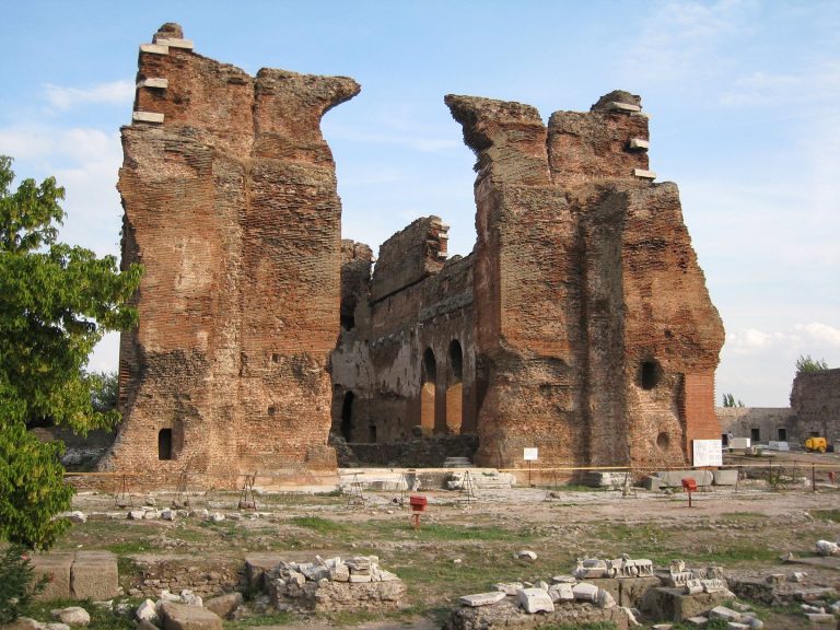
The Red Basilica, also called the Temple of Isis and Serapis, lies about 1 kilometre south of the acropolis. Built under Hadrian, it occupied an enclosed sacred precinct, or temenos, measuring approximately 100 by 265 metres. Porticoes bordered three sides of the precinct, much of which is now covered by modern buildings.
The main building was a brick structure about 60 by 26 metres, originally faced with marble and fitted internally with two-storey colonnades. Water basins stood at its centre beside a monumental walk-in statue, probably of Serapis. Two domed circular buildings, each more than 16 metres high, flanked the main temple and probably served cultic purposes. Forecourts with water basins and covered colonnades stood beside the main building and circular structures. The columns took the form of paired male and female Caryatid figures. In the Byzantine period, a three-aisled basilica was inserted into the temple.
Inscriptions
Greek inscriptions from Pergamon include the Astynomoi inscription, which sets out rules for municipal officials. Its provisions illuminate Greek regulation of road maintenance, public and private water supply, and lavatories, adding evidence for the civic systems that supported the city’s built environment.