Castle of Gallifa: A Medieval Fortress and Religious Site in Catalonia, Spain


Visitor Information
Google Rating: 4.4
Popularity: Very Low
Google Maps: View on Google Maps
Country: Spain
Civilization: Unclassified
Remains: Military

History
The Castle of Gallifa is situated in the municipality of Gallifa, Spain. It originated as a medieval fortress serving as the historic and administrative hub of the surrounding lands in Catalonia.
Long before the medieval era, the site shows traces of early settlement, with archaeological findings revealing walls built by the Iberians around the 8th century BCE. This evidence points to a long-standing human presence well before the castle’s construction.
The castle itself first appears in records dating to 999 CE. Initially under the authority of the Count of Barcelona, it was entrusted to the Gallifa family, who adopted their name from the castle. The family’s lineage is documented beginning in 1060 with Ramon, son of Adaltrudis, and continues with his son Bernat Ramon de Gallifa, notable for also holding the castle of Clarà in Moià. Around 1115, following Bernat Ramon’s death, ownership passed to his children: Ramon Bernat, associated with Maçanet, and Rodlendis, who married into the Rocafort family. This arrangement created a shared lordship, or condominium, between the Gallifa-Maçanet and Rocafort clans.
Throughout the following centuries, the castle changed ownership several times. In 1160, it was transferred either by sale or as a feudal grant to the Rocafort family. By 1348, Bernardo de Guasius de Petra is recorded as the lord of the castle. From 1357 until 1564, the Centelles family occupied the fortress, overseeing the surrounding territory.
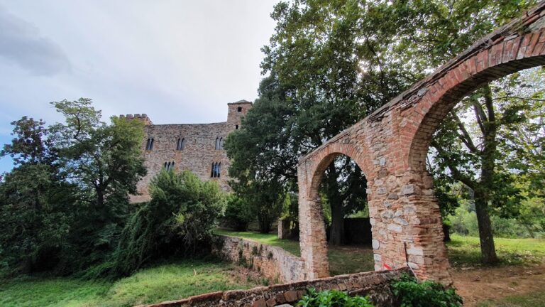
In 1564, a significant change occurred when the residents of Gallifa purchased exemption from royal taxation for 10,000 sous from King Philip II, reflecting local efforts toward greater autonomy. Around this period, the castle ceased to operate as a military stronghold and shifted its role to serve as the seat of the parish of Santa Maria del Castell. It fulfilled this religious function until 1860, when parish responsibilities were moved to Sant Sebastià de Montmajor.
The original religious image associated with Santa Maria del Castell was lost during the Spanish Civil War between 1936 and 1939. In 1985, restoration efforts led by priest Josep Dalmau revived the ruined Romanesque chapel, dedicating it as the Sanctuary of the Mother of God of Ecology. This new spiritual focus incorporated a newly named 11th-century Virgin statue discovered near Olot, the Mare de Déu de l’Ecologia. Since this restoration, the site has served as a place emphasizing ecological values linked to Christian teachings, highlighted by symbolic installations including a sapling descended from the famous Pi de les Tres Branques tree.
Remains
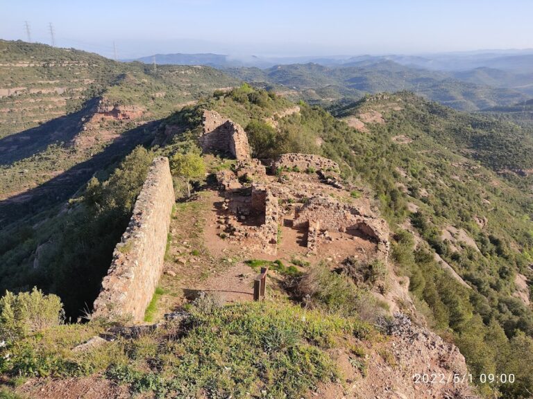
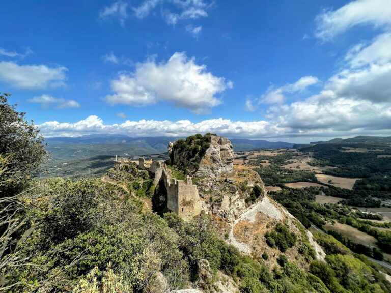
The Castle of Gallifa sits atop a fortified hilltop measuring approximately 600 meters in height. Its original layout consisted of a walled plateau encircled by defensive walls, featuring two main gateways complete with adjoining lookout towers on the west and east sides. Presently, only fragments of these enclosing walls survive, marking the summit area where the chapel and ruins of other structures remain visible.
At the western extremity stands a quadrangular tower, whose two vaulted floors have been preserved, though a third once existing floor has been lost. This tower likely played a critical role in the castle’s defensive system.
Next to the castle ruins lies the fortified Romanesque church of Santa Maria del Castell, constructed during the 11th century on the site’s highest point at 642 meters above sea level. The church is characterized by its straightforward rectangular plan with a single nave covered by a barrel vault—a continuous semicircular ceiling shape. The most distinctive feature is its semicircular apse, covered by a quarter-sphere vault and standing almost like a tower, its exterior ornamented solely by Lombard arcades and blind arches—small decorative arches built into the walls without openings.
Of particular note is the church’s heightened walls, approximately twice as tall as typical for similar rural churches from the period. These thick walls contain embrasures (or espitlleres), narrow slits designed for defense, indicating the church’s secondary use as a refuge for castle inhabitants during attacks.
The building includes three windows, each with a semicircular arch and double splayed openings, found respectively on the west and south walls and within the apse. Access is granted through a door in the south wall, which also supports a two-eyed wall bell tower.
Archaeological study reveals multiple construction phases: the apse is a fully developed example of 11th-century Lombard Romanesque style, while the nave likely dates from the late 11th to early 12th century. The unusually tall walls probably result from enlargements made during the 12th century.
Due to its deteriorated condition by the late 20th century, a rectangular building situated between the chapel and a semicircular tower was demolished in 1985 to facilitate restoration.
Today, the area within the remnants of the castle’s perimeter has been transformed into a park containing various symbolic elements connected to ecology, climbing, and mountaineering, reflecting the site’s renewed spiritual and cultural purpose.
Nearby sites