Hierapolis-Pamukkale: An Ancient Healing City and UNESCO World Heritage Site in Türkiye
Table of Contents


Visitor Information
Google Rating: 4.8
Popularity: High
Google Maps: View on Google Maps
Official Website: www.turkishmuseums.com
Country: Turkey
Civilization: Byzantine, Greek, Roman
Remains: City
Context
Hierapolis is situated at Pamukkale in Denizli province, western Türkiye, positioned atop a limestone plateau overlooking extensive travertine terraces formed by mineral-rich thermal springs. The site occupies a strategic location at the head of the Büyük Menderes (Meander) valley, where the natural outflow of hot carbonate waters shaped both the landscape and the settlement’s development. The thermal springs, with their distinctive white travertine deposits, have influenced the city’s spatial organization and attracted human activity since prehistoric times.
Archaeological evidence attests to continuous use of the springs and associated cult practices from the Phrygian period onward. The city was reestablished as a Hellenistic polis under the Attalid dynasty in the 2nd century BCE, later incorporated into the Roman province of Asia. Roman imperial patronage fostered urban expansion and the construction of monumental civic and religious buildings. Subsequent Late Antique and Byzantine occupation layers reveal ongoing habitation, punctuated by seismic events that repeatedly damaged the city and prompted phases of reconstruction. Over the medieval centuries, archaeological strata indicate a gradual contraction of the inhabited area.
European travelers documented the ruins from the 18th century, while systematic archaeological investigations commenced in the late 19th century under German direction. Subsequent Turkish and international projects have recovered inscriptions, architectural remains, and material culture that clarify the site’s long occupation sequence. The travertine terraces and archaeological ensemble are subject to conservation and controlled public access. In 1988, UNESCO designated Hierapolis-Pamukkale as a World Heritage Site, recognizing its combined natural and cultural significance.
History
Hierapolis, located in the Lycus valley of western Anatolia, represents a site of enduring religious, cultural, and urban significance shaped by its unique geothermal environment and shifting political dominions. Originating as a Phrygian cult center, it evolved into a Hellenistic city under the Attalid dynasty and later became an integral part of the Roman province of Asia. The city gained renown as a center for healing and religious activity, enduring repeated seismic destruction and political transitions through Byzantine and Seljuk periods before its eventual abandonment in the late medieval era. Modern archaeological research has elucidated a complex stratigraphy reflecting these regional historical dynamics.
Iron Age and Phrygian Period (ca. 7th century BCE and earlier)
Prior to Greek colonization, the site functioned as a prominent Phrygian religious sanctuary dedicated to the Anatolian mother goddess Cybele. Excavations conducted in 2016 uncovered Iron Age round huts on the slopes of Çökelez Mountain overlooking the Lycus River plain, confirming substantial pre-Hellenic habitation. The cult temple, likely constructed in the first half of the 7th century BCE, was situated above a cave emitting lethal carbon dioxide gas, regarded as an entrance to the underworld. Eunuch priests of Cybele were uniquely believed to withstand the toxic fumes, performing rituals within the cave. With the arrival of Greek settlers, the indigenous cult was syncretized with Hellenic religious concepts, associating the sanctuary with Hades (Pluton) and Persephone and renaming it the Ploutonion, thereby integrating local and Greek mythologies.
Hellenistic Period (3rd–2nd century BCE)
Following the decline of Phrygian dominance, Hierapolis was refounded as a Hellenistic city under the Seleucid dynasty during the reign of Antiochus I (281–261 BCE) and later attained polis status under Eumenes II of Pergamon (197–160 BCE). The city’s urban fabric was organized on a grid plan centered on a principal colonnaded street approximately 1,500 meters long and 13.5 meters wide, flanked by monumental gates and arcades. Hierapolis developed a diversified economy, notably producing high-quality wool textiles and dyes. Antiochus the Great resettled approximately 2,000 Jewish families from Babylon and Mesopotamia into Lydia and Phrygia, including Hierapolis, where the Jewish population may have reached up to 50,000 by 62 BCE. The city expanded following the 190 BCE Battle of Magnesia, after which Eumenes II, allied with Rome, annexed much of Asia Minor, including Hierapolis, under the Treaty of Apamea. The thermal springs gained prominence as therapeutic centers, attracting physicians who utilized the waters for healing. Coinage minted in the 2nd century BCE bears the name Hieropolis, reflecting civic identity linked either to the original temple (hieron) or to Hiera, wife of Telephus, a figure in Attalid foundation myths.
Roman Period (133 BCE – 4th century CE)
In 133 BCE, following the death of Attalus III, the kingdom of Pergamon, including Hierapolis, was bequeathed to Rome and incorporated into the Roman province of Asia. Although Hierapolis was not established as a Roman colony, it underwent significant Romanization and urban redevelopment, particularly after catastrophic earthquakes in AD 17 and AD 60, the latter leaving the city in ruins. Imperial patronage facilitated reconstruction, resulting in the city’s present urban form. The theatre, constructed in 129 CE to commemorate Emperor Hadrian’s visit and later renovated under Septimius Severus (193–211 CE), accommodated approximately 15,000 spectators. In 215 CE, Emperor Caracalla conferred the prestigious title of neocoros upon Hierapolis, granting sanctuary privileges and enhancing its religious status.
During this period, Hierapolis flourished as a cultural, religious, and economic center. Public amenities included two Roman baths, a gymnasium, multiple temples, a monumental fountain at the hot spring, and a 2nd-century CE nymphaeum distributing water through an advanced pipe system. The city’s hot springs, with temperatures ranging from 36 to 57 °C and containing bicarbonate, sulfate, carbon dioxide, iron, and radioactive elements, attracted visitors seeking therapeutic bathing and drinking cures. The Ploutonion cave remained a significant religious site where priests demonstrated immunity to lethal carbon dioxide emissions, serving as an oracle and economic resource. The extensive necropolis, extending over two kilometers along the main road outside the city walls, contains approximately 1,200 tombs of diverse types, including elaborately decorated marble sarcophagi and monumental family tombs. Notably, the sarcophagus of Marcus Aurelius Ammianos depicts the earliest known crank and connecting rod mechanism, illustrating advanced local technology. The city was also the birthplace of the Stoic philosopher Epictetus.
Christianity emerged early in Hierapolis, with Apostle Paul founding a church during his time in Ephesus and Apostle Philip spending his final years in the city. The martyrium commemorating Philip’s crucifixion was established around AD 80. The Temple of Apollo Lairbenos, the city’s principal deity in the late Hellenistic period, was rebuilt in Roman style in the 3rd century CE and situated deliberately over a seismic fault associated with the Ploutonion. The city’s fortifications were enhanced in the late 4th century, incorporating reused materials from earlier structures. Emperor Valens made the last recorded imperial visit in 370 CE during his campaign against the Sassanid king Shapur II.
Late Antiquity and Christianization (4th–6th centuries CE)
By the 4th century CE, Christianity had become the dominant religion in Hierapolis, leading to the suppression of pagan cults. The Ploutonion was deliberately filled with stones to prevent continued ritual use. The Roman baths were converted into a Christian basilica, reflecting the transformation of urban religious spaces. The bishopric of Hierapolis, originally part of the province of Phrygia Pacatiana, was elevated to metropolitan status by Emperor Justinian in 531 CE, underscoring the city’s ecclesiastical importance. The 5th-century martyrium of St. Philip features an octagonal plan with a wooden dome covered in lead tiles, surrounded by eight rectangular rooms and heptagonal chapels, richly adorned with marble panels and mosaics. In 2011, the tomb of Philip was reportedly rediscovered approximately 40 meters from the martyrium.
Repairs to the Nymphaeum in the 5th century included the construction of a retaining wall using stones from the Apollo temple enclosure, effectively obscuring the pagan sanctuary. Byzantine gates were erected in the 6th century, and statues of priestesses from this period have been excavated and are displayed in the local museum. These developments reflect continued, albeit diminished, urban occupation and the city’s religious transformation during Late Antiquity.
Medieval Period (7th–14th centuries CE)
The early medieval period was marked by significant challenges for Hierapolis. Persian invasions in the early 7th century, followed by a major earthquake, caused extensive destruction and hindered recovery. Archaeological evidence indicates a contraction of the urban area and abandonment of many public buildings. By the 12th century, the region fell under the control of the Seljuk Sultanate of Konya. In 1190, Crusader forces led by Frederick Barbarossa, allied with Byzantines, briefly occupied the area. The city was abandoned around the early 13th century, with the Seljuks constructing a castle on the site, reflecting a shift toward military rather than civic functions. The settlement was deserted by the late 14th century, and the 1354 Thracian earthquake further devastated remaining structures. Over subsequent centuries, the ruins were gradually buried beneath thick travertine deposits.
Modern Rediscovery and Excavation (19th century to present)
European travelers documented the ruins of Hierapolis from the 18th century onward. Systematic archaeological excavations began in 1887 under German archaeologist Carl Humann, who conducted initial surveys and drilling operations. Humann’s work laid the groundwork for later investigations, although it was limited in scope. From 1957, Italian-led excavations under Paolo Verzone and successors expanded knowledge of the site, uncovering major public buildings, residential quarters, and Byzantine structures. Restoration projects initiated in 2008 have re-erected columns along the main street and conserved key monuments.
The travertine terraces, known as Pamukkale, became a prominent natural attraction in the 20th century, though early hotel construction caused damage to some archaeological remains. Modern conservation measures have since mitigated such impacts. Since 1984, the great Roman baths have housed the Hierapolis Archaeology Museum, which exhibits artifacts spanning over 4,000 years from Hierapolis and surrounding ancient cities. Many statues and reliefs excavated at Hierapolis are displayed in museums across Europe, reflecting the site’s rich cultural heritage and its significance for understanding Anatolian history.
Daily Life and Importance by Period
Iron Age and Phrygian Period (ca. 7th century BCE and earlier)
During the Iron Age, Hierapolis functioned primarily as a religious sanctuary dedicated to Cybele, the Anatolian mother goddess. The local population consisted mainly of indigenous Phrygian communities, as evidenced by round huts excavated on the slopes of Çökelez Mountain. Social organization centered on religious elites, particularly eunuch priests who uniquely accessed the toxic gas-emitting cave beneath the temple, regarded as a gateway to the underworld. Daily activities focused on cult rituals, with limited evidence for extensive economic or administrative functions. Subsistence likely involved pastoralism and small-scale agriculture typical of the Lycus valley. Material culture remains suggest simple domestic interiors without elaborate decoration. Trade and market activity appear minimal, with the site’s significance rooted in its religious role rather than economic or civic functions. The gradual assimilation of the Phrygian cult into Greek religious frameworks foreshadowed the city’s evolving identity.
Hellenistic Period (3rd–2nd century BCE)
The Hellenistic refoundation transformed Hierapolis into a planned polis featuring a grid street layout and monumental gates, reflecting increased urbanization and civic organization. The population diversified, incorporating Greek settlers, Attalid administrators, and a substantial Jewish community resettled by Antiochus the Great, estimated at tens of thousands by the mid-1st century BCE. Social hierarchy included civic magistrates, artisans, textile producers, and religious officials overseeing both traditional Anatolian and Hellenistic cults. Economic life expanded with textile manufacture and dyeing as prominent industries, conducted at household and workshop levels. The thermal springs attracted physicians who practiced therapeutic bathing, integrating health services into the urban economy. Domestic interiors likely featured mosaic floors and painted walls, paralleling contemporary Hellenistic cities in Asia Minor. Markets provided venues for trade in local agricultural products, textiles, and imported goods accessed via regional trade routes along the Meander valley. Religious life blended Phrygian and Greek deities, with the Ploutonion cave maintaining ritual significance. Civic institutions included councils and magistrates under Attalid patronage, with inscriptions attesting to named officials. Hierapolis served as a regional center for textile production, religious pilgrimage, and healing, marking a shift from a cult site to a multifaceted urban community.
Roman Period (133 BCE – 4th century CE)
Following incorporation into the Roman province of Asia, Hierapolis experienced urban renewal and Romanization, especially after destructive earthquakes in AD 17 and 60. The population grew to an estimated 100,000, comprising Roman citizens, local Anatolians, Greek-speaking inhabitants, Jewish communities, and slaves. Social stratification included wealthy landowners, imperial officials, artisans, religious leaders, and a significant slave population. Inscriptions mention duumviri and other municipal magistrates managing civic affairs. Economic activities diversified: large-scale textile production continued alongside agriculture, while the city’s renowned thermal springs underpinned a thriving health and spa industry. Workshops and public baths indicate industrial and service sectors operating at both household and institutional scales. Archaeological finds reveal diets rich in bread, olives, fish, and local produce, with domestic spaces adorned by mosaic floors and frescoes. The extensive necropolis reflects varied burial customs and social status.
Markets thrived along the main colonnaded street, offering local and imported goods transported by animal caravans and regional road networks. The theatre and gymnasium hosted cultural and social events, while religious life was vibrant, encompassing pagan temples (Apollo Lairbenos, Ploutonion), early Christian communities, and imperial cult worship. Christianity’s emergence introduced new ecclesiastical roles, with Apostle Paul founding a church and Apostle Philip’s martyrium becoming a pilgrimage site. Hierapolis held the prestigious neocoros title, granting sanctuary privileges and elevating its civic status. The city functioned as a major religious, cultural, and economic hub in the province, integrating traditional Anatolian practices with Roman imperial institutions.
Late Antiquity and Christianization (4th–6th centuries CE)
The transition to Late Antiquity saw Christianity become dominant, reshaping religious practices and urban life. The pagan Ploutonion was deliberately closed and filled, while the Roman baths were repurposed as a Christian basilica. The population remained urban but diminished, with social organization increasingly centered on the bishopric, elevated to metropolitan status by Justinian in 531 CE. Clerical elites gained prominence alongside remaining civic officials. Economic activity contracted but sustained essential functions, with repairs to infrastructure such as the Nymphaeum indicating ongoing municipal maintenance. Domestic architecture included richly decorated Christian buildings, mosaics, and marble paneling, reflecting continuity in interior decoration adapted to new religious uses. Diet and trade likely focused on local agricultural products, with reduced long-distance commerce.
Religious life revolved around Christian worship, with the martyrium of St. Philip serving as a focal point for pilgrimage and liturgical ceremonies. Byzantine gates and fortifications were constructed, signaling continued strategic importance. Social customs adapted to Christian norms, and inscriptions attest to ecclesiastical leaders and priestesses. Hierapolis’s role shifted from a pagan healing center to a Christian metropolitan see, maintaining regional religious significance despite demographic decline.
Medieval Period (7th–14th centuries CE)
The early medieval period brought demographic contraction and disruption due to Persian invasions and earthquakes. The population shrank, and urban functions diminished, with archaeological layers showing reduced occupation and abandonment of many public structures. By the 12th century, the site came under Seljuk control, with a castle constructed reflecting military priorities rather than civic administration. Economic life was limited, likely focused on subsistence agriculture and small-scale crafts supporting the remaining inhabitants and garrison. Domestic architecture was modest, with Byzantine houses uncovered from the 11th century indicating continued, though reduced, settlement. Trade and market activity were minimal compared to earlier periods. Religious practices shifted under Islamic Seljuk rule, though Christian communities may have persisted in diminished form. The city lost its metropolitan status and civic institutions dissolved. The final abandonment in the late 14th century followed further seismic destruction and political instability. Hierapolis’s role transitioned from a metropolitan religious center to a strategic military outpost before complete desertion.
Modern Rediscovery and Excavation (19th century to present)
Although not a period of occupation, archaeological excavations since the late 19th century have illuminated daily life across Hierapolis’s history. Systematic digs revealed urban layouts, domestic architecture, and artifacts illustrating diet, clothing, and crafts. Finds such as sarcophagi with technological depictions and inscriptions naming magistrates enrich understanding of social organization. Restoration of monumental streets, baths, and religious buildings has clarified the city’s civic structure and economic roles over time. Museum collections display household items, statues, and reliefs that reflect cultural and religious diversity. These investigations confirm Hierapolis’s evolution from a Phrygian cult site to a Roman healing metropolis and later Christian center, providing a comprehensive picture of daily life and regional importance through successive periods.
Remains
Architectural Features
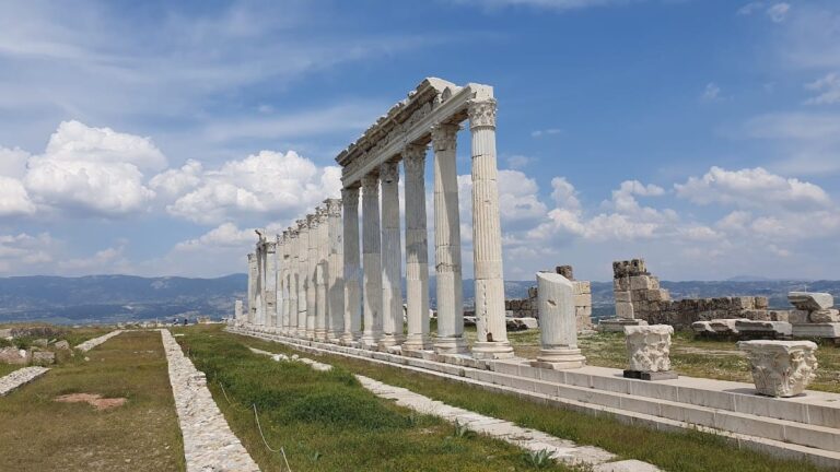
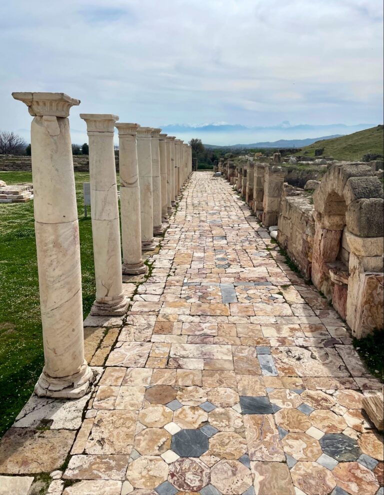
Hierapolis was constructed on a grid plan with streets aligned parallel and perpendicular to a principal north-south colonnaded street. This main thoroughfare extended approximately 1,500 meters in length and 13.5 meters in width, bordered by arcades on both sides. Side streets branching from it measured about 3 meters wide. The city’s architecture predominantly employed large ashlar stone blocks and marble elements, reflecting a complex urban fabric comprising civic, religious, and residential structures. Over time, particularly during the medieval period, the urban area contracted, as evidenced by reduced building density and archaeological layers indicating abandonment phases. The adjacent travertine terraces and thermal springs significantly influenced the city’s location and architectural development.
City fortifications were reinforced in the late 4th century CE with walls and gates incorporating reused materials from earlier structures, including the Agora. The northern gate, part of this Theodosian fortification system, was flanked by square towers and featured apotropaic marble brackets carved with animal heads such as lions, panthers, and Gorgons. The city’s layout and surviving remains indicate a primarily civic and religious character, with residential quarters identified through excavated Byzantine houses.
Key Buildings and Structures
Main Street and City Gates
The main street, developed during the Hellenistic and early Roman periods, ran adjacent to a cliff with travertine terraces. It was lined with arcades and shops, forming the city’s commercial axis. Monumental gates stood at both ends. The Domitian Gate, constructed between 84 and 86 CE by proconsul Julius Frontinus, is a triumphal arch flanked by circular towers with three arches. The northern city gate, part of the late 4th-century Theodosian fortifications, was built using stone blocks recycled from the demolished Agora and flanked by two square towers. Four large marble brackets with lion, panther, and Gorgon heads were found collapsed before this gate, serving as protective symbols.
Theatre
The theatre was likely constructed under Emperor Hadrian following the earthquake of 60 CE. Its facade, measuring 91 meters in length, remains fully standing. The seating area (cavea) originally comprised 50 rows divided into seven sections by eight stairways, with a horizontal walkway (diazoma) separating lower and upper tiers. Two vaulted passageways (vomitoria) provided access. An imperial box was centrally located, and a 1.83-meter-high wall enclosed the orchestra. During the early 3rd century CE under Septimius Severus, the stage building (scaenae frons) was replaced by a monumental three-storey facade with side entry buildings, decorated with mythological reliefs and inscriptions. Marble seats replaced limestone, and a high podium was added to the orchestra to accommodate animal hunts and gladiatorial events. The stage was 3.7 meters high, featuring five doors and six niches, with ten marble columns in front. The wall behind the stage had three rows of columns, the front row unfluted. The theatre could seat approximately 15,000 spectators, though only 30 rows survive. It was segmented into nine aisles by eight vertical passageways with steps. The proscenium had two stories with decorated niches. Several statues and reliefs of Apollo, Dionysus, and Diana were excavated and are displayed locally. The theatre underwent restorations between 2004 and 2014. In 352 CE, the orchestra was likely converted into an arena for aquatic shows. The theatre collapsed after a 7th-century earthquake, contributing to the city’s abandonment.
Temple of Apollo
The Temple of Apollo Lairbenos, the city’s principal deity during the late Hellenistic period, was situated within a Doric-style enclosure (peribolos) measuring approximately 15 by 20 meters. Only the foundations of the original Hellenistic temple survive, along with architectural fragments such as two Ionic capitals and a 1st-century CE Corinthian capital, indicating an earlier structure. The temple featured a marble staircase and was located within a sacred precinct approximately 70 meters long, enclosed by a temenos wall. The back of the temple was built against a hill, and the peribolos was surrounded on three sides by a partially excavated marble portico with pilasters bearing fluted Doric semi-columns and decorated capitals. In the 3rd century CE, the temple was reconstructed in Roman style using recycled stone blocks; only the marble floor remains from this phase. Geological studies have identified the temple’s location on a seismic fault, known as the Gateway of Hades. The temple was deliberately built over this fault, associated with the Ploutonion, the oldest native religious center where Apollo was linked with Cybele. In the 4th century CE, after Christianity became dominant, parts of the temple’s enclosure were dismantled to construct a large Nymphaeum.
Ploutonion
Two structures at Hierapolis are identified as Ploutonion. One lies adjacent to the Temple of Apollo within its sacred area, and a second is located about 200 meters east, corresponding to ancient descriptions. The Ploutonion near the Apollo temple is a small cave accessible through a fenced entrance, with stairs descending inside. It emits suffocating carbon dioxide gas due to subterranean geological activity. Behind the 3-square-meter roofed chamber is a deep cleft with fast-flowing hot water releasing a sharp-smelling gas. Castrated priests of Cybele were believed immune to the toxic fumes and entered the cave to demonstrate divine protection. An enclosed area of about 2,000 square meters in front of the entrance was covered by a thick layer of lethal gas, dangerous to animals and humans. Priests sold birds and other animals to visitors to test the gas and offered oracular consultations for a fee. The Ploutonion’s entrance was walled off during Christian times and has been recently excavated.
Nymphaeum
The Nymphaeum, dating from the 2nd century CE, is located inside the sacred area in front of the Temple of Apollo. It functioned as a shrine to the nymphs and a monumental fountain distributing water to city houses through an intricate pipe network. The structure has a U-shaped plan and lies along the continuation of the main colonnaded street. In the 5th century CE, it was repaired during the Byzantine era, including the construction of a retaining wall using elements from the Apollo temple’s enclosure, which obscured the pagan sanctuary. A Byzantine gate was added in the 6th century; only the back wall and two side walls survive. Walls and niches were decorated with statues, including two priestess figures excavated by Italian archaeologists and displayed in the local museum. The surrounding area contained statues, shops, and canals passing underneath. Two large doors from the late 1st century CE remain outside the city walls near this area.
Necropolis
The necropolis extends over two kilometers beyond the city walls along the ancient road to Phrygian Tripolis and Sardis, also reaching south toward Laodicea and Colossae. It is among the best-preserved necropolises in Turkey, containing approximately 1,200 tombs primarily constructed from local limestone, with some marble elements. Tombs date mainly from the late Hellenistic period, with significant numbers from Roman and early Christian times. Types include simple graves for commoners, sarcophagi raised on substructures or hollowed from rock, many with double-pitched roofs, mostly marble and decorated with reliefs and epitaphs. Circular tumuli with narrow passageways leading to vaulted chambers are present, as well as larger family graves resembling small temples. Numerous travertine lahids (stone coffins) bear Greek inscriptions with the Soros suffix, some over 2,000 years old. The oldest graves are Hellenistic tumulus graves on the eastern foothill, featuring stone drum cylinders bonding the burial chamber tops, accessible via corridors (dromos). Northern city tombs from the 2nd and 3rd centuries CE are generally enclosed by walls and have gardens with flowers and cypress trees. Grave monuments made entirely of travertine include simple lahids and home-like graves with multiple lahids. Sarcophagi often bear inscriptions such as “bomas” (“altar”), symbolizing the deceased’s memory. The sarcophagus of Marcus Aurelius Ammianos, a local miller, depicts the earliest known machine with a crank and connecting rod mechanism, showing a waterwheel powering two frame saws; the inscription is in Greek. This sarcophagus was stored in the Hierapolis Museum as of 2014 and not displayed. Earthquake damage is visible in the necropolis, with large travertine areas destroyed. Excavations have uncovered graves with long inscriptions and early Hellenistic epigraphic marble blocks. Byzantine ramparts and graves with marble lahids on stone bases and tiled roofs decorated with colored wall paintings have been found on the hillside. The grave of Tiberius Cladius Talamos, with a facade resembling a house, is located on the road to Laodicea and Colossae.
Martyrium of St. Philip
The martyrium, dating from the 5th century CE, is situated on a hill outside the northeastern city walls. It is said to contain the tomb of St. Philip at its center, though the exact location remains unverified. A gravesite was announced about 40 meters from the martyrium in 2011. The structure burned down at the end of the 5th or early 6th century, as indicated by fire marks on columns. Tradition holds that Philip was martyred by crucifixion upside-down or hanging by his ankles. The martyrium’s architectural design likely involved a Byzantine imperial architect. It features a central octagonal structure approximately 20 meters in diameter, covered by a wooden dome with lead tiles. Surrounding the octagon are eight rectangular rooms, each accessible through three arches; four served as church entrances, four as chapels. Spaces between these rooms contain heptagonal chapels with triangular apses. The dome above the apse was decorated with mosaics. The entire building is encircled by an arcade with marble columns, and all walls were covered with marble panels. Inscriptions indicate the church was dedicated to “the holy and glorious apostle and theologian Philip,” reflecting historical debate about the identity of Philip of Hierapolis.
Great Baths
The Great Baths, among the largest buildings in Hierapolis, centered on natural thermal pools. Constructed during the Roman period, they served as a health center with more than fifteen bath complexes in the city. The current Antique Pool formed after a 7th-century earthquake caused the marble portico with Ionic columns to collapse into the spring. Thermal water temperatures range from 36 to 57 °C, with a pH of 5.8 and a radon value of 1480 pCi/L. The spa water contains bicarbonate, sulfate, carbon dioxide, iron, and radioactive elements, suitable for bathing and drinking cures. The baths’ architectural remains include vaulted halls and stuccoed ceilings.
Basilica Baths
Constructed outside the north gate at the beginning of the 3rd century CE, the Basilica Baths were later converted into a Christian church around the 5th century. The building featured vaulted ceilings with stucco decoration and halls adorned with marble slabs. The structure’s remains include portions of the vaulted ceilings and wall decorations.
Museum
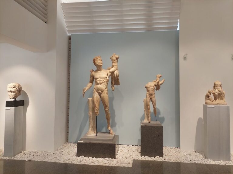
The Archaeology Museum has been housed in the Great Baths since 1984. It contains artifacts from Hierapolis and nearby ancient cities such as Laodicea, Colossae, Tripolis, and Attuda. The collection includes a large section devoted to Bronze Age artifacts from Beycesultan Hüyük and items from Caria, Pisidia, and Lydia. Exhibition spaces consist of three enclosed areas within the baths and open areas formerly used as a library and gymnasium. The open areas mainly display marble and stone artifacts. The Tombs and Statues Gallery contains sarcophagi, statues, funerary monuments, pedestals, columns, and inscriptions, including depictions of local customs on family tombs. The museum also exhibits decorative theatre reliefs with mythological scenes and imperial portraits related to the theatre.
Other Remains
Excavations in 2016 uncovered Iron Age round huts in the Northern Necropolis area, indicating a large settlement on the slopes of Çökelez Mountain overlooking the Lycus River plain. The Phrygian temple dedicated to Cybele, probably built in the first half of the 7th century BCE, was constructed on the site of a cave emitting toxic gases, later assimilated into Greek religion as the Ploutonion. Surface traces and architectural fragments suggest the presence of other temples or shrines dedicated to Cybele, Artemis, Pluto, and Poseidon near the Temple of Apollo. Byzantine houses, including an 11th-century courtyard house, have been excavated. The city walls and gates incorporate reused materials from the Agora demolition. The hot springs and travertine terraces form a significant natural feature adjacent to the city.