Château de l’Ours: A Medieval Fortress in Sainte-Thérence, France


Visitor Information
Google Rating: 4.3
Popularity: Low
Country: France
Civilization: Medieval European
Site type: Military
Remains: Castle
History
The Château de l’Ours is a medieval fortress located in the commune of Sainte-Thérence in modern-day France. This stronghold was constructed by the medieval French nobility to defend the frontier region near Montluçon during the Middle Ages.
Plans for such a defensive site date to the late 12th century when the threat of English incursions through the region was a pressing concern. However, delays meant that the castle was not completed until the early 13th century. In 1210, Guy II de Dampierre, the lord of Bourbon, undertook the building of the Château de l’Ours at the request of monks from the nearby Abbey of Menat. The fortress was constructed at the same time as Château de Ronnet, with the strategic purpose of monitoring potential invasions along the Cher River. Its position formed part of a watch system guarding this contentious border area between the historical regions of Auvergne and Berry.
The site functioned primarily as a small lordly stronghold overseeing river crossings in this frontier zone rather than a large military fortress. Its name, Château de l’Ours, or “Castle of the Bear,” is linked to a local legend involving Odile de Montluçon. According to tradition, her son was raised within the castle wearing a bear’s skin, causing shepherds in the area to mistake him for an actual bear. Over time, this folk tale gave rise to the castle’s distinctive name.
By the late 20th century, the historical and cultural importance of the site was recognized officially. The Château de l’Ours received protection under French heritage laws, earning historic monument status in 1995, preserving its legacy as part of the region’s medieval heritage.
Remains
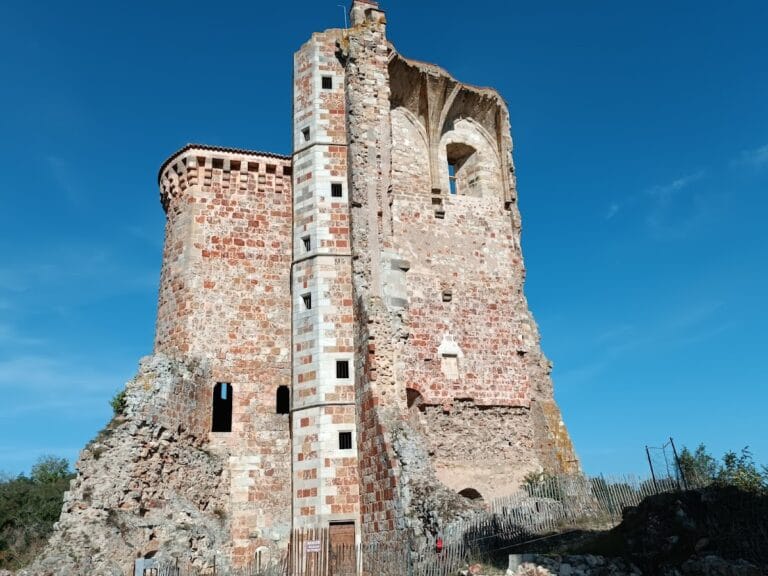
The Château de l’Ours is situated atop a rocky ridge that overlooks where the Cher River meets its smaller tributary, the Petite Rivière de l’Ours. This natural elevation provided a commanding view of the surrounding area and an ideal location to control river traffic and monitor movements across the border zone. The rocky promontory measures roughly 50 meters in length and narrows to about 12 meters in width, shaping the footprint of the fortress.
Dominating the ensemble is a cylindrical stone tower referred to as the keep, which rises to nearly 19 meters tall and spans approximately 9.5 meters in diameter. Characteristic of medieval military architecture, the keep was the core defensive and residential building within the castle. Access to this tower was originally gained on the first floor through a small adjoining tower positioned on the upstream side of the structure, a common security feature designed to protect the entrance by elevating it above ground level.
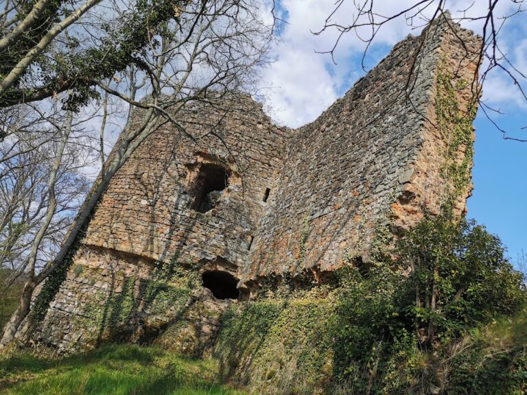
Surrounding the keep is a curtain wall—a low defensive wall—that once enclosed the main stronghold area. This wall closely followed the contours of the rocky ridge, reinforcing the natural fortifications provided by the terrain. Although the curtain wall now lies largely in ruins, its original alignment is still clearly visible, indicating the castle’s modest scale and its function as a watchtower rather than a sprawling fortress.
Today, the remains of the Château de l’Ours stand as a testament to its historical role guarding an important river crossing and border area in medieval France. The ruins, with elements like the surviving keep and the trace of the enclosing wall, illustrate the castle’s defensive design and its integration with the rocky landscape it was built to command.
Nearby sites