Roman Aqueduct of Andelos: An Ancient Hydraulic System in Navarra, Spain


Visitor Information
Google Rating: 4.6
Popularity: Very Low
Google Maps: View on Google Maps
Country: Spain
Civilization: Roman
Remains: Infrastructure

History
The Roman Aqueduct of Andelos is located in Mendigorría, Navarra, Spain. It was constructed by the Romans within the territory of the Vascones people, in the province of Tarraconensis during Roman Hispania. The aqueduct served the city of Andelo, a Roman settlement that developed on a pre-existing Iron Age Vasconic village.
Before Roman control, the site hosted a small Vasconic community during the 4th and 3rd centuries BCE. Roman occupation began in the early 2nd century BCE, leading to urban development and the establishment of Andelo as a significant city. The settlement reached its height in the 1st and 2nd centuries CE, when it was granted the status of civitas by Emperor Vespasian in 74 CE. Ancient authors such as Pliny the Elder and Ptolemy mention Andelo, noting its role as a stipendiary city within the administrative district of Caesaraugusta.
The city continued to exist into the medieval period, with records showing an 11th-century church linked to Santa Maria of Pamplona. However, Andelo was abandoned around the mid-14th century, likely due to the devastating plague of 1348. The aqueduct and other Roman structures fell out of use as the city declined.
Archaeological interest in Andelo began in the 1940s, with early excavations uncovering parts of the urban fabric. Systematic campaigns from 1980 to 2000 revealed extensive remains of the city’s infrastructure, including the aqueduct. These efforts led to the creation of the Museo Arqueológico de Andelo, preserving and interpreting the site’s heritage.
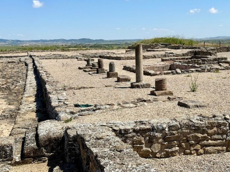
Remains
The archaeological site of Andelo covers about 18 hectares on a plateau with steep slopes to the northeast. The city was enclosed by defensive walls with two towers at the northwest and southeast corners. Its urban plan follows a Roman grid with two main east-west streets (decumani) and three north-south streets (cardines), forming rectangular blocks called insulae. The upper terrace contains residential buildings, public baths, and taverns, while the southwest area includes workshops, warehouses, and a fullonica, a laundry facility.
The aqueduct complex is a prominent feature dating from the Roman period. It includes two dams at Iturránduz, discovered in the 1980s, which controlled water flow. Water was channeled through a canal and an aqueduct system composed of a stone channel and lead pipes. The pipes used a siphon mechanism to cross uneven terrain, an advanced technique for the time.
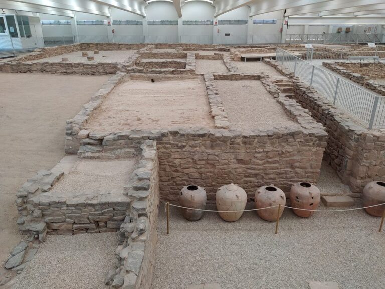
A key element is the castellum aquae, a water distribution reservoir built as a rectangular stone podium with thick walls coated internally with three layers of waterproof plaster. Originally vaulted, it has multiple spouts on its eastern side, likely supplying a public fountain. The water source was at Puente del Diablo, where containment structures were found. From there, water flowed into a large underground cistern measuring 85 by 37 meters, capable of holding about 7,000 cubic meters.
Residential buildings from the 1st century CE show floors made with opus signinum, a waterproof mortar, some decorated. One floor preserves an inscription in the Iberian alphabet, a rare find linking local culture with Roman urban life. Other notable discoveries include a bronze plaque dedicated to Apollo and a mosaic illustrating the Triumph of Bacchus.
Today, many remains of the hydraulic system and urban structures are visible in situ. The archaeological museum on site displays artifacts and explains the city’s water management. The preservation of the aqueduct and related features offers insight into Roman engineering and urban planning in this part of Hispania.
Nearby sites