Odiavum Fort: A Roman Military Site on the Danube Frontier in Hungary


Visitor Information
Google Rating: 4.6
Popularity: Low
Google Maps: View on Google Maps
Official Website: azaum.hu
Country: Hungary
Civilization: Roman
Remains: Military

History
Odiavum Fort was established by the Romans near present-day Almásfüzitő in Hungary, along the Danube River frontier in the province of Pannonia. It guarded the border between the Roman Empire and the Germanic Quadi tribe. The site was originally inhabited by the Illyrian Azal tribe before Roman control.
The fort likely dates to the early 2nd century AD, founded during Emperor Trajan’s reign (98–117 AD). Early evidence includes brick stamps from the Ala I Bosporanorum cavalry unit and Legio XI Claudia. Initially, the fort was built using wood and earth materials. It served as a military post between the larger legionary bases of Brigetio to the west and Crumerum to the east.
Under Emperor Antoninus Pius (138–161 AD), the fort was rebuilt in stone by the Ala III Augusta Thracum sagittaria, a cavalry unit of Thracian archers granted Roman citizenship. This reconstruction marked a significant upgrade in the fort’s defenses and permanence. The fort’s name appears as Azaum in the 3rd-century Itinerarium Antonini and as Odiavum or Odiabum in the 5th-century Notitia Dignitatum, though the reason for these different names remains unclear. Inhabitants were known as Odiavenses from inscriptions.
During the 3rd century, the fort underwent modifications, including the addition of gate towers, likely under Emperor Caracalla (211–217 AD). The fort remained active throughout this century, adapting to changing military needs. In the late 4th century, further renovations introduced fan-shaped corner towers typical of late Roman military architecture. At this time, three of the four gates were sealed, leaving only the northern Porta Praetoria open.
A smaller late Roman fort was constructed in the northwest corner during the late 4th century. This diamond-shaped fort housed units such as the Equites Dalmatae cavalry. The main fort and its vicus, a civilian settlement, were abandoned in the early 5th century, with the latest archaeological finds dating to this period.
The vicus developed alongside the fort from around 80–110 AD, inhabited by soldiers’ families, craftsmen, and merchants. It was fortified with ditches and featured stone-paved streets and painted walls. Increasing barbarian attacks in the late 3rd and early 4th centuries led to the vicus’s abandonment, with residents retreating into the fort. Some former vicus areas were converted into cemeteries during this time.
Religious life at Odiavum is attested by finds such as lead votive objects depicting the deity Silvanus. Burial practices included diverse grave types with goods like jewelry, weapons, and household items, reflecting the community’s social and military character.
In modern times, the site suffered damage from industrial development, especially the 1976 construction of a red sludge reservoir for aluminum production, which buried much of the archaeological remains under toxic waste. Excavations in the 20th and early 21st centuries have helped document the fort’s history and layout.
Remains
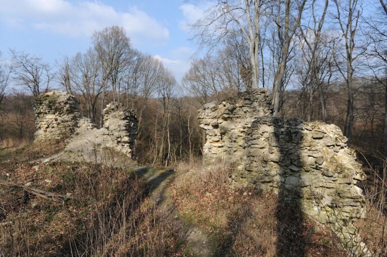
Odiavum Fort was a rectangular stone fort measuring approximately 166 by 203 meters, enclosing about 3.37 hectares. It featured rounded corners typical of Roman forts from the Principate period. The fort’s main street, the via principalis, ran northwest to southeast and was about 9 meters wide, connecting the west and east gates.
The fort’s walls were 2.2 meters thick and protected by two V-shaped double ditches, each 3.5 meters wide. Behind the walls, an earthen rampart served as a fighting platform. This rampart was made from earth dug from the ditches and surfaced with yellow and black turf bricks. Four corner towers originally square were later replaced in the 4th century by large fan-shaped towers projecting beyond the walls.
Each of the four gates faced a cardinal direction and originally had a single passageway. In the early 3rd century, likely under Caracalla, gate towers were added flanking each gate. These towers measured about 6 by 6.5 meters externally and projected slightly from the walls. Later, the northern tower of the west gate was enlarged inward, and the gate itself was walled up, a change seen in other frontier forts.
A smaller late Roman fort, or kleinkastell, was built in the northwest corner after partial abandonment of the main fort. It measured roughly 33 by 32.5 meters with thick mortar-rich walls. This fort was constructed independently but reused stone and materials from the main fort and vicus.
Surrounding the fort, the vicus featured a planned street grid aligned with the fort’s roads. Early dwellings were pit-houses, later replaced by stone buildings with painted walls. The vicus was enclosed by a ditch system serving both defense and drainage. Excavations revealed stone-paved roads and frescoed rooms, including one measuring 3 by 3.5 meters.
Archaeological finds include military equipment such as iron scale armor fragments, stone catapult projectiles, and various weapons. Personal items found include jewelry like gold earrings, silver rings, and bronze fibulae (brooches) decorated with mythological motifs such as winged birds and the three-headed dog Cerberus. Pottery was mainly produced in nearby Brigetio workshops.
The vicus cemeteries contained 36 inhumation and 4 cremation graves with diverse burial types, including stone chamber graves, brick graves, sarcophagi, and simple earth graves. Grave goods included vessels, knives, coins, jewelry, and military items. Animal bones, including decapitated domestic fowl, were found in a joint grave, interpreted as food offerings.
A Roman stone sluice associated with the limes road was located south of the fort. It appeared on 17th and 18th-century maps but was demolished in 1747 during drainage works. The fort and vicus were protected from flooding by a stone embankment and drainage system with parallel stone-lined ditches. This embankment supported the limes road and was maintained into the early medieval period before partial demolition in the 18th century.
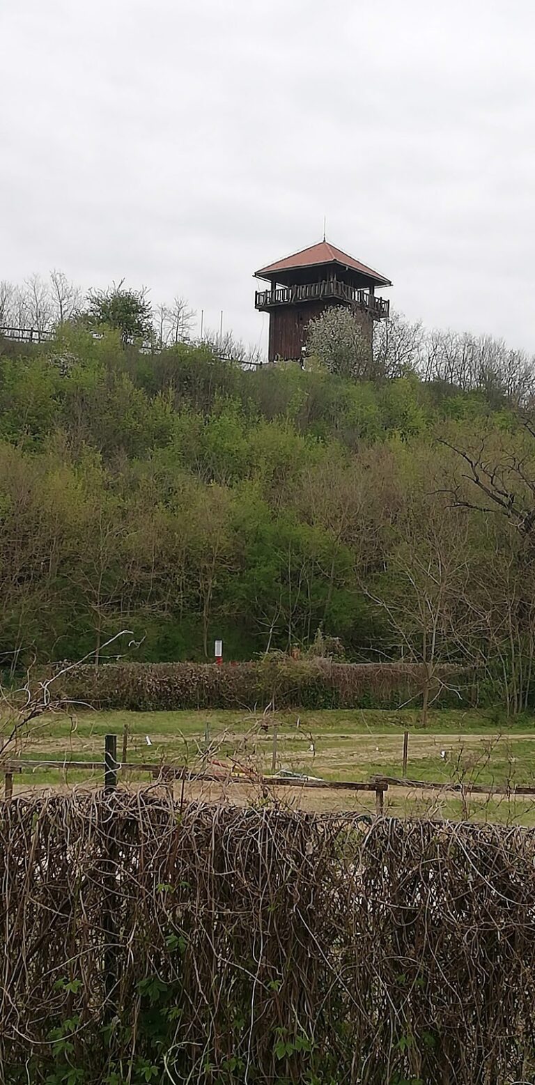
Today, many finds from Odiavum are preserved in regional museums, including inscriptions, military gear, and personal artifacts. A reconstructed watchtower and a historical park near the site help illustrate the fort’s military and civilian past.
Nearby sites