Ludlow Castle: A Historic Norman Fortress in England


Visitor Information
Google Rating: 4.6
Popularity: Medium
Google Maps: View on Google Maps
Official Website: www.ludlowcastle.com
Country: United Kingdom
Civilization: Medieval European
Remains: Military

History
Ludlow Castle, situated in the town of Ludlow in England, was established by Norman builders after the Norman Conquest of 1066. Founded around 1075 by Walter de Lacy, the castle originally bore the name Dinham Castle. Its strategic position on a rocky promontory overlooking the River Teme allowed it to serve as the central fortification for Walter de Lacy’s estates, making it among the earliest stone castles constructed in England.
During the 12th century, Ludlow Castle was a focal point in the civil conflict known as The Anarchy, which involved rival factions vying for control during a period of weakened royal authority. The de Lacy family and challengers such as Roger FitzMiles and Josce de Dinan contested possession of the castle. During this turbulent time, the fortress was strengthened with a Great Tower, also called a donjon, and a large outer courtyard, known as an outer bailey, was added to enhance its defenses.
In the 13th century, ownership transferred to Geoffrey de Geneville, who rebuilt sections of the inner courtyard or bailey and took part in the Second Barons’ War, a conflict between rebellious nobles and the crown. Between 1250 and 1290, Geoffrey constructed significant buildings including the Great Hall, where large assemblies met, and the Solar block, which was the private living quarters.
At the start of the 14th century, Roger Mortimer acquired Ludlow Castle and around 1320 added the Great Chamber block, a grand residential space. Mortimer also built a chapel in the outer bailey dedicated to Saint Peter. His renovations emphasized Norman architectural traditions and featured chivalric symbols, illustrating the castle’s role not only as a fortress but as a statement of noble prestige.
In 1425, the castle became linked to the Yorkist faction through Richard, Duke of York, who inherited it. Ludlow Castle served as a regional administrative center during the Wars of the Roses, a series of dynastic conflicts. In 1461, the castle passed into the hands of the Crown under King Edward IV, further cementing its status in royal governance.
From the late 15th century through the 17th century, Ludlow Castle functioned as the seat of the Council of Wales and the Marches, effectively acting as Wales’s administrative capital. This council combined judicial and governmental duties, using the castle to hold court sessions and manage regional affairs.
By the early 17th century, the castle’s interiors were richly appointed, and it became a venue for cultural events, notably the 1634 debut of John Milton’s masque Comus. During the English Civil War, Ludlow Castle was held by Royalist forces until it was besieged and taken by Parliamentarian troops in 1646. Afterward, its furnishings were sold, and it was used as a garrison base during the Interregnum period when England lacked a monarch.
Following the Restoration of the monarchy in 1660, the Council of Wales was reinstated, and repairs were made to Ludlow Castle. However, the site never fully recovered its earlier importance. When the Council was abolished in 1689, the castle fell into gradual neglect and decline.
In 1772, Henry Herbert, 1st Earl of Powis, leased Ludlow Castle from the Crown. He undertook landscaping of the grounds and basic repairs, efforts which his son George Herbert, 2nd Earl of Powis, continued by improving and stabilizing the castle’s ruins. The castle was purchased outright in 1811 by Edward Clive, who was connected by marriage to the Powis family. Clive converted the former tennis court and the adjacent Castle Inn within the outer bailey into a mansion called Castle House, which was leased to local gentry.
During the 19th century, especially after Ludlow gained a railway connection in 1852, the castle drew increasing attention from artists and visitors. It saw diverse uses such as grazing land, locations for sporting events, and storage for militia ammunition.
Archaeological research began in 1903, led by W. H. St John Hope and Harold Brakspear. Their discoveries were published in 1909. In 1915, Ludlow Castle was formally protected as an ancient monument, though it remained under the ownership of the Powis family.
During the Second World War, the castle served Allied military purposes. The Great Tower was used as a lookout point, while the gardens provided recreational space. Castle House was requisitioned for housing war workers, resulting in some damage.
From the 1970s onward, partners including English Heritage worked with the Powis Estate to fund repairs and maintenance. Efforts included stabilizing curtain walls and developing visitor facilities. Limited archaeological excavations took place in the outer bailey in the early 1990s.
Today, Ludlow Castle remains in the hands of the Earl of Powis and functions as a historic site hosting cultural events. It is recognized as one of the most complete and significant castle complexes in England.
Remains
Ludlow Castle occupies a roughly rectangular area measuring about 152 by 133 meters (500 by 435 feet), covering approximately 2 hectares (5 acres). It sits atop a rocky plateau approximately 30 meters above the nearby River Teme and River Corve. The castle comprises two main enclosures: a smaller inner bailey containing the core defensive and residential buildings, and a much larger outer bailey serving functional and service purposes. A third, innermost bailey was formed in the early 13th century through the addition of a thick stone wall enclosing part of the inner bailey’s southwest corner.
The castle walls, constructed primarily of greenish-grey siltstone rubble with carefully shaped red sandstone blocks used for corners and detailing, merge into the medieval town walls of Ludlow along the south and east. Later structures primarily employ local red sandstone.
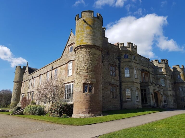
Entry into the outer bailey is through a gatehouse that leads into two distinct sections. The northern side of the outer bailey houses Castle House, a two-storey mansion built between 1820 and 1828 on the site of an earlier tennis court and inn. Castle House adjoins Beacon Tower, an elevated structure overlooking the town below.
On the eastern side of the outer bailey stand two prominent 16th-century stone buildings: the porter’s lodge and the prison. Each is a two-story structure of finely cut ashlar stone measuring approximately 12 by 7 meters and 18 by 7 meters respectively. The prison’s exterior was once decorated with painted coats of arms belonging to Henry, Earl of Pembroke, and Queen Elizabeth I, though these have since been lost. Beyond these buildings lies a rubble stone stable block about 20 by 6.4 meters in size. Along the southern edge of the outer bailey are the remains of St Peter’s Chapel, dating to the 14th century. This chapel, roughly 6.4 by 15.8 meters, was later converted into a courthouse with an upper-level courtroom and storage beneath. A modern wall separates the chapel area from the southwestern corner of the outer bailey.
Mortimer’s Tower, a 13th-century D-shaped tower on the western curtain wall of the outer bailey, measures around 5.5 meters wide externally. Originally serving as a three-story gatehouse, its entrance was blocked in the 15th century to convert it into a tower built into the curtain wall, with an additional floor added in the 16th century. Although the tower is now roofless, its vaulted ground-floor chamber—about 3.7 meters square—remains intact.
The inner bailey is surrounded by thick curtain walls measuring between 1.5 and 1.8 meters wide. To the south and west, a rock-cut ditch up to 24 meters deep offers substantial defense, crossed by a bridge that still retains some original 16th-century sandstone blocks. The gatehouse leading into the inner bailey, constructed in 1581, displays coats of arms belonging to Sir Henry Sidney and Queen Elizabeth I. This three-story building originally featured transomed windows and open fireplaces, and functioned likely as lodgings for judges attending the court. A now-lost spiral staircase in a projecting tower with triple chimneys once provided controlled access.
Adjacent to the inner bailey’s gatehouse was a half-timbered building thought to have served as a laundry facility. Measuring approximately 14.6 by 4.6 meters, this structure has not survived.
On the east side of the inner bailey stands the circular Romanesque chapel of Saint Mary Magdalene, dating from the 12th century. Modeled after the Church of the Holy Sepulchre in Jerusalem, this sandstone chapel measures about 8 meters in diameter and originally included a square presbytery section. The building was heavily altered during the 16th century, leaving only the roofless nave, which survives to its full height and features 14 arcaded bays with some original plasterwork on the lower walls.
The north side of the inner bailey contains several prominent buildings. The Solar block, Great Hall, and Great Chamber block stand together, forming much of the residential complex. The Tudor Lodgings occupy the northeast corner and consist of two rhomboid-shaped buildings separated by a dividing wall and accessed via a shared spiral staircase. These lodgings initially provided offices and private rooms for court officials and were later adapted into two separate apartments.
Constructed around 1320, the Great Chamber block is a rhombus-shaped building approximately 16 by 10 meters, originally featuring a grand chamber on the first floor. Carved corbel heads within the structure may represent King Edward II and Queen Isabella. Behind this block is the four-story Guardrobe Tower serving combined functions as chambers and garderobes, or medieval toilets.
The 13th-century Great Hall, measuring about 18.3 by 9.1 meters, was originally located on the first floor and displayed a classical medieval hall layout with a long rectangular form. It featured a wooden floor supported by stone pillars, a massive roof, and three large south-facing windows designed with trefoil shapes, each including window seats. The hall’s central open hearth was later replaced around 1580 by a fireplace built into the middle window.
West of the Great Hall lies the Solar block, a three-story irregular oblong about 7.9 by 11.9 meters. This block contained the solar, or family dining room, on the first floor and servant quarters below. Both the Great Hall and Solar were constructed simultaneously in the 13th century, involving the removal of a previous Norman tower behind the hall.
Two Norman towers, dating from the late 11th and early 12th centuries, stand to the north behind the main range. These towers, known as the North-West and North-East (or Pendover) towers, originally featured timber floors and rear walls which were later replaced with stone. The North-East Tower was expanded to three stories in the 14th century and remodeled in the 16th century. Both towers display chamfered external corners designed to resist attacks, although this architectural detail reduced overall structural strength.
The Closet Tower, added in the 13th century near the North-West Tower, changed its external appearance. Also located in the innermost bailey are two other Norman towers: the West Tower, sometimes called the Postern Tower for its small secondary gate, and the South-West Tower, known as the Oven Tower from its kitchen ovens. These towers face toward Wales, likely indicating a symbolic defensive posture.
A former range once extended from the innermost bailey toward the Great Hall, including several important buildings. Among these were a large stone house along the curtain wall measuring approximately 16.5 by 6.1 meters, the Great Kitchen at about 9.4 by 7 meters, and a separate oven building roughly 6.4 by 8.2 meters in size.
The Great Tower, or donjon, is a roughly square, four-story keep located on the south side of the innermost bailey. Its walls are thick, measuring around 2.6 meters in most parts, with a slightly thinner northern wall built later. Originally serving as a large gatehouse with accommodation above the gateway, it was converted into a keep in the mid-12th century but continued to function as a gatehouse for some time. When the innermost bailey was enclosed in the early 13th century, the original gateway was filled in, and a new entrance was cut to the east. The tower’s northern side was rebuilt in the mid-15th century into its present form.
Inside the Great Tower, the vaulted basement rises about 6.1 meters and contains Norman-style wall arcading dating from around 1080, echoing decorative motifs found in the chapel. Originally, the first floor housed a tall hall measuring approximately 8.8 by 5.2 meters, which was later divided into two separate floors.
The castle’s architecture reveals a complex history of construction and alteration from the 11th through the 17th centuries. Norman masonry and Romanesque elements coexist with medieval defensive walls and later Tudor and Perpendicular Gothic adaptations visible in the surviving ruins.
Castle House, situated in the outer bailey, is a two-story mansion built in the early 19th century. It contains a drawing room, dining room, study, servants’ quarters, and a conservatory with grapevines. Recently renovated in the early 21st century, Castle House now serves as office space and rented apartments.
Nearby sites