Dunstanburgh Castle: A Fourteenth-Century Coastal Fortress in England


Site at a Glance
- Rating
- 4.6
- Popularity
- Medium
- Country
- United Kingdom
- Primary era
- Medieval
- External website
- Open
- Eras represented
- Iron Age, Medieval, Modern
- Civilizations
- British, English
- Site type
- Military
- Remains
- Castle
On this page22 sections
History
Dunstanburgh Castle is a fourteenth-century coastal fortification in the United Kingdom, built under Thomas, 2nd Earl of Lancaster, on the Northumberland coast between Craster and Embleton. Its construction began by May 1313 and was probably complete by 1322. The castle combined the natural strength of the headland with earlier earthworks and became both a northern fortress and a powerful expression of Thomas’s authority.
Earlier occupation and Lancastrian construction
The headland was probably occupied in prehistoric times. An Iron Age promontory fort, protected by earthwork defences, was established here possibly from the third century BC and continued into the Roman period. By the fourteenth century these defences had been abandoned, and the land formed part of the cultivated barony of Embleton, traditionally held by the earls of Lancaster.
Thomas began building Dunstanburgh during a period of growing conflict with his cousin, King Edward II. A royal licence to crenellate, permitting the construction of fortified battlements, was issued in 1316, and a constable, the official responsible for a castle’s command and upkeep, was appointed in 1319. Thomas may have intended the castle as a secure retreat from royal forces based in southern England. He also appears to have considered creating a planned settlement beside it and moving the people of Embleton to the new site.
The work was supervised by a mason known as Master Elias, possibly Elias de Burton, who had previously worked at Conwy Castle. Iron, coal from Newcastle, and timber from Scandinavia were brought to the headland. By the end of 1313, £184 had been spent, and building continued for several years. Some of the outer wall may have been constructed by labourers from Embleton fulfilling their feudal obligations.
Thomas made little use of the completed fortress and may have visited it only once, probably in 1319. During the civil conflict of 1321–22, he tried to reach Dunstanburgh while fleeing royal forces, but Sir Andrew Harclay intercepted him before he arrived. Thomas was captured at the Battle of Boroughbridge and later executed. The castle then passed to the Crown and was used as a northern stronghold against Scottish attacks.
Royal fortress and Lancastrian inheritance
Dunstanburgh was initially administered by Robert de Emeldon, a merchant from Newcastle. Its garrison consisted of 40 men-at-arms and 40 light horsemen. Roger Maduit, a former member of Thomas’s army who had regained political favour, became constable, followed in 1323 by Sir John de Lilburn and later by Roger Heron. Maduit and the garrison fought at the Battle of Old Byland in 1322. The garrison was subsequently increased to 130 men, mainly light horsemen, as the castle became part of the northern defence against Scotland.
In 1326 the Crown returned Dunstanburgh to Thomas’s brother, Henry, 3rd Earl of Lancaster, with John de Lilburn again serving as constable. The fortress continued to support military operations against Scottish incursions in the following decades. John of Gaunt, 1st Duke of Lancaster, acquired it through his marriage to Blanche, granddaughter of Henry of Lancaster, in 1362. As Lieutenant of the Scottish Marches, the border regions administered for defence against Scotland, Gaunt visited the castle in 1380 and ordered further defensive work because of Scottish raids and the poor condition of the fortifications.
During the Peasants’ Revolt of 1381, Gaunt considered Dunstanburgh too insecure to provide him with refuge. This led to further improvements between 1382 and 1384 under the constable Thomas of Ilderton and the mason Henry of Holme. The entrance to the Great Gatehouse was blocked so that the building could function as a keep. A Scottish army attacked in 1384, but lacked the equipment needed to besiege or capture the fortress. When Gaunt’s son Henry IV became king in 1399, the Duchy of Lancaster was incorporated into the Crown.
The castle remained involved in the defence of the eastern route towards Scotland. Its constable, and probably its garrison, took part in the Battle of Homildon Hill in 1402. During the reign of Henry VI, repairs were ordered after the buildings and outer defences had fallen into disrepair.
Wars of the Roses and decline
During the Wars of the Roses, the fifteenth-century dynastic conflicts between the houses of Lancaster and York, Dunstanburgh formed part of a chain of fortifications protecting the eastern route into Scotland. The castle changed hands several times. Sir Ralph Percy surrendered it to supporters of Edward IV in September 1461, and it surrendered again after a Yorkist siege at Christmas 1462. Percy returned it to the Lancastrians the following year, but the Earl of Warwick reoccupied it after a short siege in June 1464. The campaigns probably damaged the castle, which never fully recovered.
From the late fifteenth century, little money was devoted to maintenance apart from minor repairs in 1470. The castle served as a base for piracy that year, and its lead roof and timber were later removed for use at Wark-upon-Tweed Castle and the moot hall at Embleton. By 1538, the gatehouse was considered habitable. Repairs ordered by Sir William Ellerker did not prevent a survey in 1543 from finding the castle in poor condition. In 1550, Sir Robert Bowes described it as being in “wonderfull great decaye.”
A 1584 assessment judged restoration too expensive and considered the castle too far from the Scottish border to justify the cost. Alice Craster occupied it from 1594 to 1597, probably living in the gatehouse, repairing parts of the building, and farming the estate. During much of the sixteenth century, local farmers paid sixpence a year for the right to shelter cattle in the outer bailey, the castle’s outer enclosed court, during Scottish attacks.
Private ownership, study, and guardianship
The union of the English and Scottish crowns in 1603 ended Dunstanburgh’s remaining military purpose. King James I sold the castle in 1604 to Sir Thomas Windebank, Thomas Billott, and William Blake. They sold it to the local landowner Sir Ralph Grey the following year. Ownership stayed with the Grey family and passed to the branch descended from Lady Mary Grey after a legal case in 1704. The surrounding land was cultivated, stone was removed from the castle for other buildings, and a small settlement called Nova Scotia or Novia Scotia may have developed at the harbour.
The descendants of Lady Mary Grey, the Earls of Tankerville, retained the property until Charles Bennet, 6th Earl of Tankerville, sold it in 1869 for £155,000 to trustees of the estate of Samuel Eyres. Restoration attempts had already been made in the early nineteenth century. The gatehouse passage was altered and reopened in 1885. Cadwallader John Bates carried out fieldwork during the 1880s and published a major study in 1891, followed by a professional plan of the ruins in 1893. Concern about deteriorating masonry was recorded in 1898.
From the late eighteenth century, the ruins attracted artists. Thomas Girtin painted the castle, and J. M. W. Turner, influenced by Girtin, first painted it in 1797 before returning to the subject in oils, watercolours, etchings, and sketches through the 1830s. Matthew Gregory Lewis helped popularise the legend of Sir Guy the Seeker in a poem published in 1808.
A golf course was established beside the castle in 1900, and Sir Arthur Sutherland, who bought the estate in 1919, opened another course in 1922 designed by James Braid. After clearance work during the 1920s, Sutherland could no longer afford to maintain the property and placed the castle under state guardianship in 1930. The Commissioners of Works then assumed control. Archaeological investigation accompanied the clearance: H. Honeyman exposed more of the main gatehouse in 1929, Robert Bosanquet undertook further work in the 1930s, and Walter Aitchison produced aerial photographs for the Ordnance Survey.
War, conservation, and interpretation
During the Second World War, the castle and coastline were incorporated in 1940 into a wider defensive line organised by Sir Edmund Ironside. The castle served as an observation post for a Royal Armoured Corps unit. The beaches were protected by barbed wire, trenches, weapons pits, and concrete pillboxes, together with a tank ditch and a large anti-personnel minefield. After the war, Italian prisoners of war removed the barbed wire. The pillboxes, parts of the anti-tank ditch, and some trenches and weapons pits survive.
Durham University carried out archaeological surveys in 1985, 1986, and 1989. English Heritage undertook a major investigation of the 35 hectares around the castle between 2003 and 2006. Sir Ivan Sutherland transferred the estate to the National Trust in 1961. Dunstanburgh remains National Trust property and is managed by English Heritage. The ruins are protected as a Scheduled Monument and a Grade I listed building, while the wider site lies within protected coastal and wildlife areas. The National Trust has encouraged waterlogged ground around the castle for amphibian and bird conservation and has prevented grazing inside the castle to encourage nesting birds.
The castle’s design has been interpreted as both military architecture and a political statement. Its towers and reflected waters made it conspicuous across the coastal landscape, which was at odds with the idea of a secret refuge. The arrangement may have evoked Camelot and the Arthurian ideals associated with aristocratic authority. Thomas used the pseudonym “King Arthur” in correspondence with the Scots.
Local traditions include the story of Sir Guy the Seeker, a knight who chooses a hunting horn instead of a sword while trying to free a woman imprisoned in a crystal tomb. His action awakens a sleeping army, and he is expelled from the castle. Other stories tell of a child escaping imprisonment, a man called Gallon recovering six Venetian glasses from the castle, and tunnels linking Dunstanburgh with nearby places. The Gallon story may echo fourteenth-century references to castle officials called Galoun, while the tunnel traditions may relate to the site’s drainage system.
Remains
Dunstanburgh occupies a headland within the Great Whin Sill, a geological formation of intrusive igneous rock extending across Northumberland. Gull Crag forms a natural barrier on the north, with cliffs rising to about 30 metres, while the south side slopes more gently towards low, wet ground. The castle’s curtain wall, the enclosing defensive wall of a castle, surrounds approximately 4.03 hectares. The interior retains traces of strip cultivation, and its buildings were arranged in three principal groups for the earl’s household, the constable and his household, and the administration of the Embleton estates.
Meres and outer landscape
Three shallow artificial lakes, or meres, formed part of the castle’s deliberately designed fourteenth-century landscape. They may have belonged to a deer park or planned borough. A freshwater spring about 610 metres inland supplied them through an underground stone channel. Sod-built banks and ditches originally bounded the landscape, and the meres were approached through gates on the north, west, and south sides.
North Mere
The North Mere covers about 2.25 hectares. Its southern half forms a 101-metre medieval moat, recorded as 5.5 metres deep, and usually retains some standing water. The northern part periodically floods to form a temporary lake. The West Mere covers about 0.91 hectares and ends at a small stone dam. Three rectangular fishponds stand beside it, including one probably used to raise young fish and supplied with water from the mere. An earthen bank extended for about 150 metres on either side of the West Gate and may once have been reinforced with a timber palisade.
South Mere and harbour
The South Mere also covers about 0.91 hectares, with the South Gate at its eastern corner. Southeast of the castle, a harbour was probably first used for construction materials and later for senior members of the household and important guests. Its surviving feature is a 75-metre quay built from basalt boulders. The harbour may have seen limited medieval use because it was safe only in good weather.
Walls and principal towers
The southern and western curtain walls were faced with local ashlar sandstone, regularly cut masonry quarried mainly at Howick, around a core of basalt rubble. Much of the sandstone facing has been removed from the western walls. At the eastern end, small limestone blocks originally rose to about 3.4 metres and supported a 1.5-metre parapet. Additional basalt blocks later raised the wall, probably during the Wars of the Roses. The northern continuation of the curtain wall along the cliffs remains uncertain.
Lilburn Tower
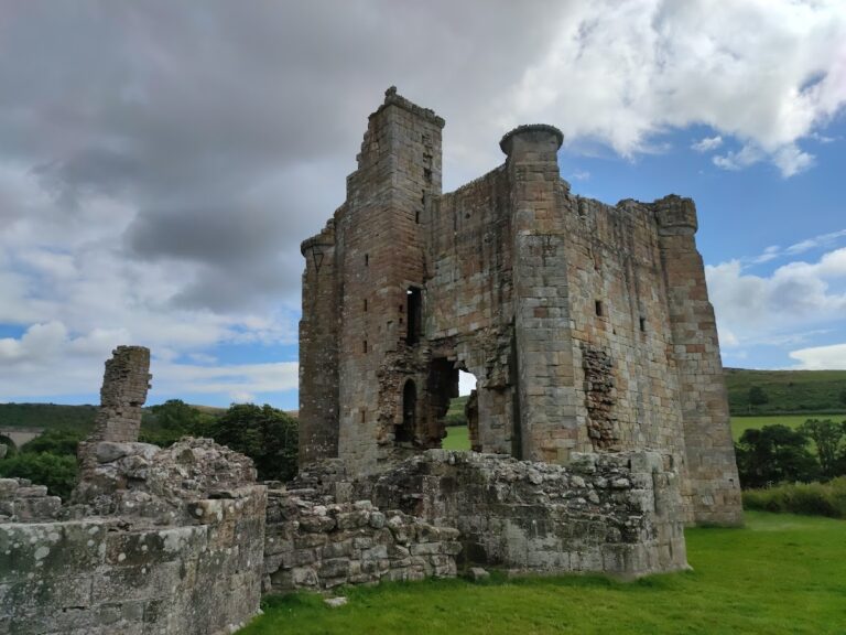
Lilburn Tower overlooks Embleton Beach and takes its name from the early constable John de Lilburn. It may have been built under Thomas of Lancaster as a high-status residence. The rectangular tower stood about 18 metres high, measured 9.1 metres square, and had walls 1.8 metres thick. Its ground floor contained a guardroom. The structure follows the rectangular-tower tradition of Northumberland and resembles towers at nearby Alnwick Castle. It stood on natural basalt pillars that strengthened its visibility from the surrounding landscape.
Huggam’s House and associated buildings
Farther along the curtain wall are the remains of a small tower traditionally called Huggam’s House. Earthworks inside the wall suggest that a building complex may once have extended between it and Lilburn Tower. Along the eastern and northern sections, a gateway gave access to Castle Point and the Gull Crag cliffs, while a postern, a smaller secondary entrance, was inserted into the eastern wall during the 1450s.
Gatehouses and inner bailey
Great Gatehouse
The Great Gatehouse stands at the southwest corner. This massive three-storey fortification is about 24 metres high and consists of two ashlar-faced, drum-shaped towers. Its design was strongly influenced by Edwardian gatehouses in North Wales, including Harlech Castle, while its projecting front towers give it a distinctive form. A 9.4-metre barbican, an outer defensive structure protecting an entrance, was added in the 1380s. Its rubble foundations survive to about 0.71 metres high.
The passage was protected by a portcullis, a vertically dropping gate, and possibly wooden gates. Two guardrooms, each about 6.4 metres wide, occupied the ground floor along with latrines. Spiral staircases in the corners led to upper chambers. The first floor held well-lit rooms with fireplaces, probably for garrison officers. The second floor contained a great hall, antechamber, and bedchamber intended for Thomas of Lancaster and his family. Four turrets rose two further storeys above the lead-covered roof and provided broad views over the surrounding landscape. The arrangement may have influenced the gatehouse later built by Henry IV at Lancaster Castle.
John of Gaunt’s Gatehouse
John of Gaunt’s Gatehouse stood immediately west of the Great Gatehouse and originally rose two or three storeys. Its surviving remains are at foundation level. It replaced the Great Gatehouse as the principal entrance and probably contained a porter’s lodge protected by a portcullis and a 25-metre barbican.
Inner bailey
An inner bailey was added behind the two gatehouses in the 1380s. Measuring approximately 15 by 23 metres, it was protected by a 6.1-metre mantlet wall. Within it stood a vaulted inner gatehouse about 9.1 metres square, together with an antechamber, kitchen, bakehouse, and three other buildings.
Constable’s and estate buildings
Constable’s Tower
The square Constable’s Tower provided relatively comfortable accommodation for the castle constable, including stone window seats. Nearby foundations belong to a hall and chamber built before 1351 as part of an approximately 18-by-18-metre complex for the constable and his household. This section of the wall also contains a projecting turret, a mural garderobe, meaning a medieval latrine built into a projecting wall, and a small oblong turret with a single chamber measuring about 3.28 by 2.29 metres.
Egyncleugh Tower
Egyncleugh Tower stands at the southeast corner above Queen Margaret’s Cove. The three-storey square tower measures about 7.6 metres across. Its name means “eagle’s ravine” in the Northumbrian dialect. It was intended as accommodation for a castle official and contained a small gateway and drawbridge, used either by the constable or by local inhabitants.
Estate centre and later earthworks
Along the inner curtain wall are the foundations of a yard measuring about 61 by 30 metres and a large rectangular building usually interpreted as a grange, an agricultural building or estate centre. It probably contained an auditor’s chamber and other facilities for managing the Embleton estates. West of the castle, a later shieling, or seasonal pastoral dwelling, survives as the earthworks of a longhouse. South of it is a rectangular earthwork with walls more than 0.99 metres high, possibly a siege fortification from the Yorkist siege of 1462. If that interpretation is correct, it is a rare surviving English example from the period.
Defensive setting and visual design
Archaeological evidence has been interpreted as suggesting an additional defensive enclosure extending from the northern area near Lilburn Tower eastwards along the coast towards the medieval harbour. Its identification and exact form remain uncertain. The Great Gatehouse faces southeast rather than the main road, possibly allowing it to be viewed from the harbour or from a planned settlement. Lilburn Tower was deliberately visible from Bamburgh Castle, about 14 kilometres away along the coast, and its position on basalt pillars enhanced its appearance and reflection in the surrounding meres.