Château de Schœneck: A Medieval Rock Castle in France


Visitor Information
Google Rating: 4.7
Popularity: Low
Google Maps: View on Google Maps
Official Website: chateau.schoeneck.free.fr
Country: France
Civilization: Medieval European
Remains: Military

History
Château de Schœneck is a ruined rock castle located near Dambach in modern-day France. It was likely built by the medieval Germanic Hohenstaufen dynasty around the late 12th or early 13th century. The castle’s initial purpose was to eliminate bandits who sheltered in the area, providing a military presence to secure local routes.
Around 1280, Château de Schœneck was destroyed but was soon rebuilt in 1286. In 1287, the castle was first recorded officially as belonging to the Bishop of Strasbourg, who was aligned with the Habsburg family. The bishop entrusted management to the noble Lichtenberg family and granted it as a fief to the Schœneck family. Serving as a fortress on the southern approach toward the town of Haguenau, the castle was part of the Lichtenberg domain known as the Amt Wörth, functioning administratively as a distinct unit called a Büttelei.
Between 1335 and 1390, under Bishop Friedrich I. von Lichtenberg, the castle underwent restoration efforts, reinforcing its defenses. Later, from 1545 to 1547, the Eckbrecht von Dürkheim family modernized the structure, adapting it to withstand the increasing use of artillery. Ownership passed through several noble families over the centuries: in 1480 to the Counts of Zweibrücken-Bitsch, in 1570 to the Counts of Hanau-Lichtenberg, and finally in 1736 to the Landgraves of Hesse-Darmstadt.
During the turbulent Thirty Years’ War (1618–1648), the castle served as a refuge but lost its military significance after the conflict. A severe forest fire in 1663 caused substantial damage, prompting partial reconstruction. The castle played a defensive role until the Dutch War when French forces repeatedly attacked it. In 1680, French generals Montclar and Mélac led a siege culminating in the castle’s destruction through explosion and systematic demolition of its fortifications.
After the French Revolution, the ruins became state property and were sold to the Dietrich family in 1820. In the late 19th century and again from 1981 to 1984, archaeological excavations uncovered significant parts of the site. Since 1984, Château de Schœneck has been protected as a Monument historique, with further preservation and partial restoration efforts continuing into the 21st century.
Remains
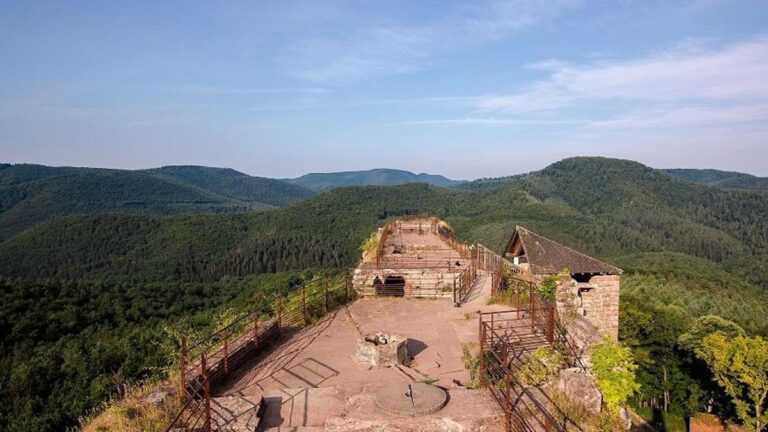
Château de Schœneck occupies a sandstone ridge about 380 meters above sea level and follows the natural contours of a 100-meter-long crest. The castle’s remains are divided into two upper sections, or Oberburgen, situated along the ridge, and two lower castles, or Unterburgen, at the base around 365 meters altitude. The site is naturally defended by steep cliffs on three sides and separated from a neighboring hill, Fischerberg, by a deep neck ditch nearly 20 meters wide.
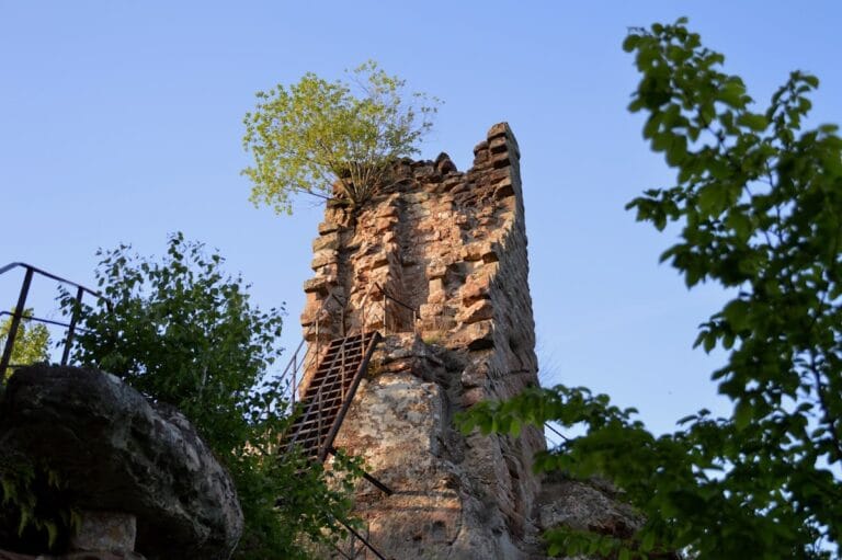
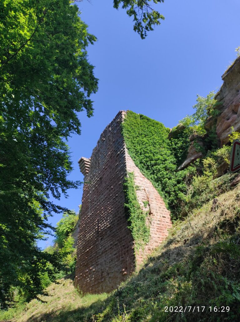
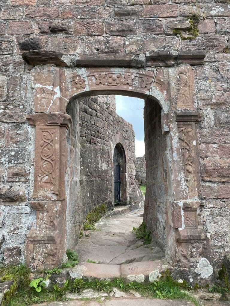
The castle’s masonry dates mostly from the mid-13th century, built from locally quarried Buntsandstein sandstone. The construction combines rubble stone with finely shaped ashlar blocks typical of the 16th century in Alsace. Notable among the defensive features is the southern entrance, secured by a 16th-century outer ditch and two square bastion towers. The eastern tower contains two artillery openings, known as Maulscharten, designed for firing small arms or light guns, while walls of the western tower rise up to two meters today.
Just beyond the main gate, foundations remain from a gatehouse with two rooms that provided access to a multi-section outer ward, or zwinger. This enclosed courtyard gave entry to the two lower castles. The western zwinger is roughly ten meters square, reached through a deep rock-cut passage. The western lower castle measures approximately 40 by 10 meters and includes a 10-meter-deep well shaft, partial curtain walls on its northern and western edges, and a round tower with a vaulted basement. Attached to its northern wall is a large U-shaped artillery tower constructed around 1500. This tower, with walls up to three meters thick, features a ground floor diameter of about 4.3 meters, including four rectangular gunports. An upper level likely served as a guardroom, projecting out beyond the main walls.
The eastern lower castle is accessed through four successive gates, ending with a 2.5-meter-wide pointed arch set into a semicircular bastion topped with a conical roof. This enclosure measures around 84 by 11 meters and contains remnants of a 20-meter-long curtain wall nearly three meters high. At its corner stands a five-sided tower from the 16th century, pierced by narrow arrow slits. Within this space are remains of a cistern, a vaulted cellar, and a semicircular tower nestled along the eastern outer wall.
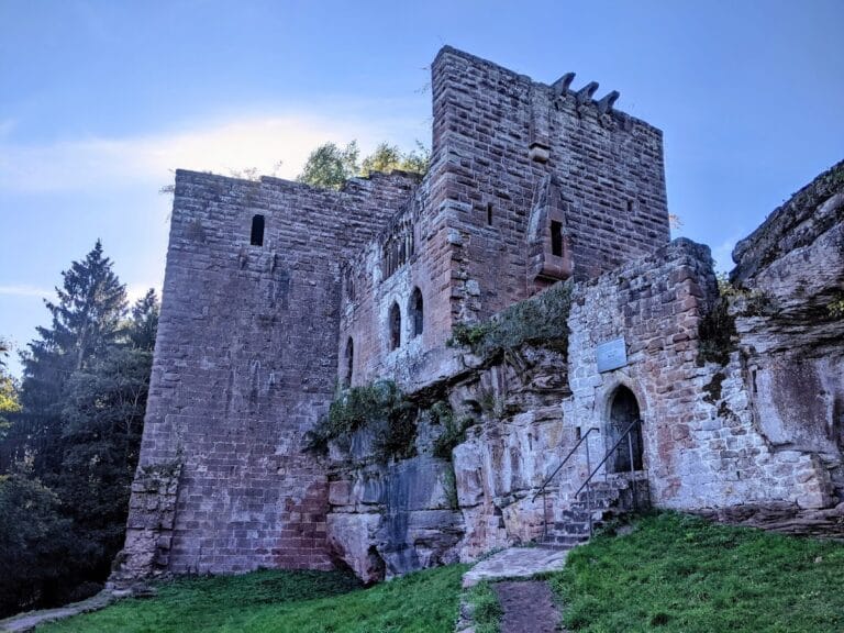
On the higher ridge, the southern upper castle consists of a single elongated building measuring 28 by 5.7 meters, with walls up to 1.7 meters thick. The northern wall preserves part of an entrance doorway. Originally, this building rose three stories high, but only the lowest levels survive.
The northern upper castle sits on a plateau about 40 meters long and 4 to 8 meters wide. It is occupied by a narrow residential building the highest walls of which remain largely in the center. An east-facing niche within this structure is interpreted as a small chapel. Access to this upper northern section was originally via stairs carved into the rock from the eastern lower castle, though these are no longer passable.
Adjacent to the northern residence is a pentagonal keep, or bergfried, with walls up to 1.9 meters thick. Built of rusticated ashlar blocks, the tower remains standing to a height of seven courses of stone. Decorative details remain visible on the lordly residences, such as Lombard friezes—ornamental bands of rounded arches—seen on two narrow semicircular-arched windows outside the western curtain wall.
Throughout the site, the use of both rough and finely dressed sandstone blocks is evident, indicating local quarrying supplemented by stone brought from about 15 kilometers away. A hoist platform survives on site, which was likely used to raise materials during construction. The castle’s relatively good state of preservation compared to others in the region owes much to its isolated location and the lack of subsequent stone removal after its ruin.
Archaeological work has revealed a forge with a basin near the main gate, confirming domestic as well as military activity. Stratified soil layers record the devastating forest fire of 1663, while a lintel from 1676 bearing an artillery embrasure provides direct evidence of the castle’s adaptation to early modern gunpowder weaponry. These features give a vivid picture of Château de Schœneck’s long and complex history as a fortified residence and military stronghold.
Nearby sites