Château de Montferrand: A Medieval Fortress in Saint-Mathieu-de-Tréviers, France


Visitor Information
Google Rating: 4.6
Popularity: Low
Google Maps: View on Google Maps
Official Website: www.chateaudemontferrand.fr
Country: France
Civilization: Unclassified
Remains: Military
History
The Château de Montferrand is a medieval fortress situated in Saint-Mathieu-de-Tréviers, France, originally constructed by the European medieval civilization on a site used since Roman times. The location, perched on a limestone ridge of the Pic Saint-Loup, built upon an earlier Roman stronghold, formed part of a defensive network rather than serving as a residential palace.
The first documented reference to the castle dates to the early 12th century when it belonged to the counts of Melgueil. This county was divided into two parts: Melgueil, now known as Mauguio, and Montferrand, which gave its name to the fortress. In 1132, the castle was officially confirmed as the property of the counts, emphasizing its importance within the regional territorial administration.
During the Albigensian Crusade, a military campaign aimed at suppressing the Cathar heresy, the castle changed hands. In 1215, it was seized from Raymond VI, count of Toulouse, one of the key leaders opposed by the crusaders. Following its confiscation, the castle was granted by papal authority to the bishop of Maguelone, who thereby acquired both spiritual jurisdiction and civil power in the area. The bishopric minted its own currency known as the denier melgorien, reflecting its dual temporal and religious authority. From 1245 onward, a castellan captain was appointed to lead and manage the fortress, signifying its ongoing military role.
In the 16th century, significant shifts affected the castle’s function and ownership. The bishopric moved its seat to Montpellier in 1536, reducing Montferrand’s ecclesiastical importance. That century also saw the castle embroiled in the French Wars of Religion: in 1574, Protestant forces captured it, but ten years later, in 1584, Antoine de Cambous reclaimed the fortress and implemented renovations that introduced Renaissance architectural influences. It was at this time that his daughter married Jean de Ratte within the castle walls, linking prominent local families.
The 17th century brought further military adaptations. Bishop Pierre de Fenouillet, in 1611, reinforced the castle’s defenses to endure artillery attacks. He added a trench carved directly into the rock and constructed the first surrounding defensive wall, known as an enceinte. The fortress endured multiple sieges during the turbulent Huguenot rebellions: Protestant troops led by the Duke of Rohan attacked it, followed later by Catholic forces commanded by Duke Henry of Montmorency. In 1623, Jacques Valat became its lifelong castellan and oversaw its defense until his death in 1659. After this period, the castle began to decline.
During the reign of Louis XIV in the early 18th century, the castle’s strategic relevance diminished to the point that demolition was authorized starting in 1709. Builders and locals were compensated with stones from the dismantled structure, though the difficulties in transporting the heavy limestone limited the extent of destruction. In recent times, ownership passed to the Grand Pic Saint-Loup community in 2009, which launched a program focused on preservation and restoration beginning in 2017. The site was closed to the public in 2018 for safety reasons, and in 2022 it earned official recognition as a historic monument, with updated classifications affirmed in 2024.
Remains
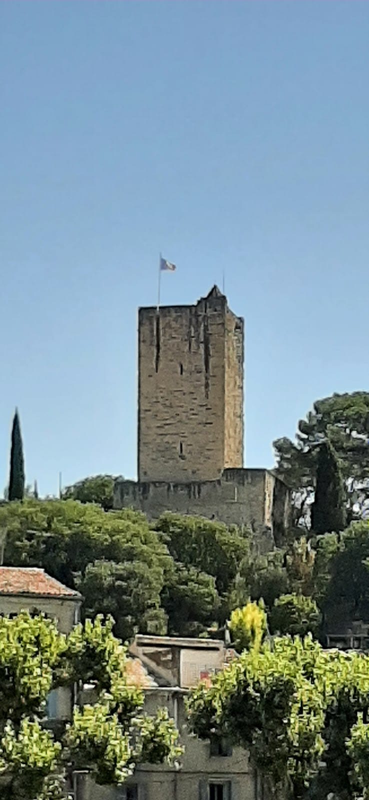
The Château de Montferrand occupies a rocky ridge set 400 meters above sea level on a limestone spur of the Pic Saint-Loup massif. This elevated position, overlooking the village of Saint-Mathieu-de-Tréviers, provided a commanding vantage point suitable for defense. The surrounding landscape is characterized by oak trees and typical Mediterranean scrub, forming a dense natural barrier. Access to the castle is possible only on foot via the GR 60 trail.
The fortress’s layout is adapted to the irregular forms of the rocky promontory, with construction primarily using local limestone extracted from the Pic Saint-Loup itself. These stones were shaped and assembled to withstand both natural erosion and military attack. Notably, the defenses enhanced in 1611 exhibit a ditch cut directly into the rock beneath the castle and a first enclosing wall, or enceinte, designed to resist the impacts of artillery becoming common in that period.
Today, the ruins preserve portions of the original walls and vaults, particularly visible on the castle’s north and west faces. Vaulted sections testify to the structural techniques used to provide stability on the uneven rock foundation. These remnants reflect centuries of construction and adaptation, from the medieval origins through Renaissance modifications.
Plans accompanying ongoing preservation efforts include reconstructing the castle chapel, a feature once integral to its spiritual functions under the bishop’s authority. Stabilizing the most fragile walls forms a key part of the conservation strategy, alongside efforts to improve site access and introduce spaces where exhibitions and cultural activities can take place. Since 2018, the entire site has been fenced off to protect visitors from falling stones and to secure areas of cliff danger, rendering it temporarily inaccessible for public entry.
The castle’s surviving elements combine natural geology and human craftsmanship and stand as a testament to its long military and administrative history, shaped by strategic necessity and religious power.
Nearby sites