Castillo de Caudete: A Historic Fortress in Caudete, Spain


Visitor Information
Google Rating: 4.2
Popularity: Low
Google Maps: View on Google Maps
Country: Spain
Civilization: Unclassified
Remains: Military

History
The Castillo de Caudete is situated in the town of Caudete, Spain. It originated as an Islamic fortress constructed during the 12th century, attributed to the Almohad dynasty, although some sources suggest the Almoravids, built atop an earlier foundation possibly dating to the period of the second Taifa kingdoms. This strategic hilltop site commanded the town center, serving as a prominent defensive position through the medieval era.
During the Middle Ages, the fortress was known as “El castell de Cabdet” and functioned as both a military stronghold and administrative center. Following the Christian reconquest of the region, the castle transitioned into a noble residence. In 1244, King Alfonso X established the lordship of Caudete and granted it to Sancho Sánchez de Mazuelo and his descendants. From that point, the fortress acted as the seat of power for the Lords of Caudete, overseeing local governance and defense.
The castle’s strategic importance intensified during the War of the Two Peters (1356–1369), a conflict between the Kingdoms of Aragon and Castile. Caudete, positioned along the contested border, witnessed military actions that damaged the original Andalusian features of the fortress. After triumphing in 1369, King Henry II of Castile financed major rebuilding efforts, shaping the surviving 14th-century Christian-era remains that endure today.
In 1422, the lordship came to an end when Garcia Jofré de Lisón sold Caudete to King Alfonso V of Aragon. Although the castle no longer served as a noble residence, it maintained a military function until the dynastic union of Aragon and Castile in 1469 removed the frontier threat. This political change reduced the fortress’s military significance and precipitated its gradual decline.
Over the 16th century, the castle was increasingly abandoned and was recorded as a ruin by 1569. Between 1740 and 1870, the site was adapted as the parish cemetery for the nearby Santa Catalina church. Following this period of burial use, it fell into neglect until the early 20th century, when it was converted into a parish garden. To enrich the soil, earth was brought in from a close Iberian-Roman archaeological site.
In the 20th century, the castle continued to suffer deterioration and intrusive development from neighboring housing. Since 1960, ownership has belonged to the Diocese of Albacete, with stewardship ceded to the Caudete City Council through 2097. Archaeological excavations and restorative work began around the year 2000 and have proceeded intermittently, uncovering several structural elements and improving preservation. In 2004, the castle surroundings were enhanced with the creation of an Andalusian-style garden named the Parque de los Reyes Católicos.
Remains
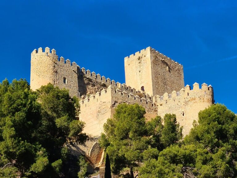
The Castillo de Caudete occupies a hilltop in the town center, featuring a polygonal layout that encloses roughly 1,800 square meters. It was constructed primarily of masonry and stone, reflecting medieval military architecture with influences from its Islamic origins later modified during Christian reconstruction.
One of the most prominent architectural features is a large alambor—a sloping base designed to strengthen the walls—that extends along the southern parapet. This element remains well preserved, illustrating medieval defensive engineering intended to deflect attacks at the base of the wall.
The battlements are crowned by thirty-four square-shaped merlons, or solid upright sections of the parapet wall, each topped with four-sided tiled roofs. These merlons are in good condition and represent a distinctive detail of the castle’s fortifications.
Within the enclosure, four masonry towers stand at the corners, their foundations revealed through archaeological excavation. The eastern tower, often called the Levante tower or tower of homage, served as the main entrance defense. Its walls exceed one meter in thickness, underscoring its importance in protecting access to the castle. Excavations also uncovered the staircase accessing the main gate, which this tower oversaw.
Archaeological work has brought to light additional key elements such as the pas de ronda, a colonial term for the walkway behind the battlements used by defenders to move along the walls, and the aljibe, a cistern used historically for water storage within the fortress. These features remain visible in situ, providing evidence of the castle’s defensive functions.
Restorations undertaken since 2000 have focused on conserving the southern and western retaining walls, alongside part of the northern tower, stabilizing and repairing these sections to maintain structural integrity. The excavations have also documented burial niches from the period when the castle served as a cemetery in the 18th and 19th centuries, as well as garden beds laid out during its later transformation into a parish garden.
The fortress is mostly free of adjacent buildings except for four houses constructed alongside the northern wall, marking the boundary between the historic structure and the modern urban environment. The 2004–2005 landscaping project established a public garden called El Albacar, also known as Parque de los Reyes Católicos, connecting the castle to the nearby Plaza de la Iglesia via a pedestrian alley. This setting complements the castle ruins without disturbing the site’s archaeological integrity.
Nearby sites