Carsulae: A Roman Municipium Along the Via Flaminia in Umbria, Italy
Table of Contents


Visitor Information
Google Rating: 4.5
Popularity: Medium
Google Maps: View on Google Maps
Official Website: www.carsulae.site
Country: Italy
Civilization: Roman
Remains: Burial, City, Civic, Domestic, Economic, Entertainment, Infrastructure, Military, Religious, Sanitation
Context
Carsulae is situated near the contemporary town of Terni in the Umbria region of central Italy. The archaeological site occupies a plateau overlooking the Nera River valley, strategically positioned along the ancient route that connected Rome to the Adriatic coast. This location placed Carsulae within a critical corridor facilitating movement and communication between the Tyrrhenian and Adriatic seas, thereby influencing its accessibility and interaction with neighboring settlements.
Established during the Roman Republic, Carsulae’s principal period of occupation extends from the late 3rd century BCE through the early Imperial era. The town developed directly along the Via Flaminia, a major Roman road completed in 220 BCE, which served as the city’s main thoroughfare. The site’s decline and eventual abandonment by the 6th century CE correspond with the broader regional disruptions of late antiquity, including the Gothic Wars and subsequent demographic and economic decline.
Due to its abandonment and limited subsequent reuse, Carsulae preserves substantial urban ruins, including segments of its road network and public buildings. Archaeological investigations began in the 19th century and have continued systematically into the modern era. Conservation efforts have focused on stabilizing extant structures and facilitating scholarly study, contributing valuable insights into Roman urbanism in central Italy.
History
Carsulae’s historical trajectory is closely linked to its position along the Via Flaminia, a principal Roman road connecting Rome with the Adriatic coast. Founded during the Roman Republic in the early 3rd century BCE, the town flourished through the early Imperial period. Its development was integrally connected to the construction and use of the Via Flaminia, completed in 220 BCE, which enhanced regional connectivity and trade. The town’s decline began in late antiquity, culminating in abandonment by the 6th century CE amid the political and military upheavals of the Gothic Wars and the broader destabilization of central Italy.
Although Carsulae never attained the status of a major urban center, its location rendered it strategically significant during periods of conflict and administrative reorganization. The town’s fortunes reflect the shifting political landscape of Umbria and the Italian peninsula, with its decline paralleling the weakening of Roman authority and the transition to the early medieval period.
Roman Republic and Early Empire (3rd century BCE – 1st century CE)
The foundation of Carsulae coincides with the Roman Republic’s expansion into central Italy. The construction of the Via Flaminia in 220–219 BCE established a direct road linking Rome to the Adriatic coast, passing through the Nera River valley near Carsulae. Archaeological evidence confirms that the town developed along this route, benefiting from increased connectivity and facilitating trade and military movement.
During this period, Carsulae was incorporated into the Roman administrative framework, likely attaining municipium status as indicated by inscriptions discovered on site. The urban layout and surviving architectural remains predominantly date to this era, reflecting Roman town planning principles. Situated within the province of Umbria, Carsulae was subject to Roman civil and military governance, contributing to regional stability and integration.
High Empire and Late Antiquity (1st – 4th centuries CE)
Throughout the Imperial period, Carsulae maintained its status as a municipium and functioned as a modest but stable settlement. The town remained part of the province of Umbria, which was incorporated into the Diocese of Italy following Diocletian’s administrative reforms in the late 3rd century CE. These reforms aimed to enhance provincial governance and defense across the Italian peninsula.
Although no fortifications have been identified at Carsulae, its location along the Via Flaminia ensured strategic importance for military and administrative transit. The town likely served as a waypoint for imperial officials and troops traveling between Rome and the Adriatic. Archaeological remains from this period include maintained road segments and public buildings, indicating continued occupation and civic activity.
Late Antiquity and the Gothic Wars (5th – 6th centuries CE)
The 5th and 6th centuries CE were marked by significant turmoil in central Italy, including the collapse of Western Roman authority and the Gothic Wars (535–554 CE). Literary sources and archaeological evidence attest to widespread destruction in Umbria, with Carsulae exhibiting layers of damage consistent with conflict and abandonment. The town’s decline accelerated as military campaigns disrupted local administration and settlement patterns.
By the mid-6th century, Carsulae was largely deserted, with no substantial evidence of post-Gothic occupation. The absence of defensive walls likely contributed to its vulnerability during this period of instability. The blocking of the western branch of the Via Flaminia during the 6th to 8th centuries, due to the so-called Longobard Corridor conflict, diverted traffic to alternative routes, further diminishing the town’s importance. This abandonment reflects broader demographic and economic decline in Umbria during late antiquity.
Post-Roman Period and Early Medieval Era
Following its abandonment as an urban center, Carsulae did not experience significant reoccupation. The site’s ruins remained largely intact, preserving the Roman urban fabric. While the surrounding region saw the emergence of new medieval settlements, Carsulae faded from historical records and was not reestablished as a populated town. No inscriptions or architectural modifications from the Byzantine or Lombard periods have been identified.
Evidence indicates a small rural settlement persisted intermittently from the 4th through the 12th centuries CE. The paleo-Christian church of San Damiano was constructed atop the remains of an earlier Roman building of uncertain function. In the 11th century, the church was expanded with a portico and interior colonnades, incorporating reused architectural elements likely sourced from the basilica or forum. During this era, Carsulae reverted primarily to agricultural use, and its ruins served as a quarry for nearby towns, preserving the site by limiting new construction.
Daily Life and Importance by Period
Roman Republic and Early Empire (3rd century BCE – 1st century CE)
Following its foundation concurrent with the Via Flaminia’s construction, Carsulae developed as a Roman municipium within the Umbrian landscape. The population comprised Roman settlers and local Umbrians, integrated into a social hierarchy that included municipal magistrates, likely duumviri, as attested by inscriptions. Family units were organized along Roman patriarchal lines, managing both urban residences and agricultural estates in the surrounding countryside.
The local economy centered on agriculture, with cultivation of grain, olives, and vines supporting the population. Small-scale craft production and workshops likely operated near the forum and tabernae, which functioned as market stalls along the via Flaminia, the city’s main street featuring sidewalks and drainage systems. The presence of a Collegium Iuvenum indicates organized educational activities for youth, reflecting civic investment in cultural formation and socialization.
Dietary evidence and regional comparisons suggest a staple diet of bread, olives, wine, and seasonal fruits, supplemented by fish from nearby rivers. Clothing adhered to Roman styles, including tunics for men and women, cloaks for outdoor wear, and leather sandals. Although domestic interiors have not been extensively excavated, the use of marble and opus sectile in public buildings suggests that some residences may have featured decorated walls and floors. Religious life centered on traditional Roman cults, with twin temples dedicated to unknown divinities near the forum indicating localized worship practices.
Carsulae functioned as a modest municipium facilitating trade and military movement along the western branch of the Via Flaminia. Its urban planning and public amenities demonstrate integration into Roman administrative and infrastructural networks, supporting regional stability and connectivity between Rome and the Adriatic coast.
High Empire and Late Antiquity (1st – 4th centuries CE)
During the Imperial period, Carsulae retained its municipium status and continued as a small but stable settlement. The population was predominantly Romanized, with civic officials administering local governance under imperial oversight. Social stratification included an elite class, evidenced by elaborately decorated public rooms featuring marble and opus sectile, which may have served as aristocratic residences or administrative offices.
Economic activities persisted in agriculture and commerce, supported by the forum’s tabernae and the via Flaminia’s role as a commercial artery. Public baths and cisterns attest to communal investment in hygiene and water management. The amphitheatre and theatre, constructed in the late 1st century BCE and Flavian period respectively, indicate a cultural life that included public entertainment and social gatherings. The Collegium Iuvenum likely continued its educational functions, fostering civic identity and youth training.
Diet and clothing remained consistent with earlier periods, with local agricultural products supplemented by imported goods accessible via the road network. Domestic interiors probably retained Roman stylistic elements, although direct evidence is limited. Religious practices included continued worship at the twin temples, with emerging Christian influences by late antiquity, as demonstrated by the paleo-Christian church of San Damiano built atop earlier Roman structures.
Carsulae’s regional importance lay in its role as a waypoint for imperial officials and military movements, particularly following Diocletian’s administrative reforms that incorporated Umbria into the Diocese of Italy. The town’s infrastructure supported both civic administration and cultural life, maintaining its function within the broader imperial system despite its modest size.
Late Antiquity and the Gothic Wars (5th – 6th centuries CE)
The collapse of Western Roman authority and the Gothic Wars profoundly disrupted daily life in Carsulae. Archaeological evidence of destruction and abandonment reflects demographic decline and the breakdown of civic structures. The population diminished sharply, with remaining inhabitants likely retreating to rural subsistence or relocating to more defensible centers.
Economic activities contracted significantly; agricultural production persisted at a minimal level, but organized commerce and public amenities fell into disuse. Public buildings, including baths and the forum, suffered damage and neglect. The absence of fortifications rendered the town vulnerable during military conflicts, contributing to its decline.
Diet and clothing would have become simpler, reflecting scarcity and reduced trade. Religious life shifted as Christianity became dominant; the paleo-Christian church of San Damiano attests to continued, albeit diminished, religious practice. Social customs and educational institutions likely ceased or transformed under the pressures of instability.
By the mid-6th century, Carsulae was largely deserted, marking the end of its role as a municipium or regional hub. Its abandonment corresponds with broader patterns of depopulation and economic contraction in Umbria during late antiquity.
Post-Roman Period and Early Medieval Era
Following abandonment as an urban center, Carsulae did not experience significant reoccupation. A small rural population may have persisted intermittently, focusing on agriculture and utilizing the ruins as a source of building materials. The construction of the church of San Damiano in paleo-Christian times, later expanded in the 11th century with reused Roman architectural elements, indicates continuity of religious presence but not urban revival.
Households during this era were likely dispersed and modest, lacking the complex urban infrastructure of earlier periods. Clothing and diet would have reflected subsistence farming and limited trade. Social organization shifted away from Roman civic institutions toward ecclesiastical authority, with the church serving as a focal point for community life.
Carsulae’s civic role ceased, supplanted by emerging medieval settlements in the region. The site’s ruins served as a quarry for nearby towns, preserving its Roman fabric by limiting new construction. Educational and cultural activities typical of the Roman municipium disappeared, replaced by localized medieval religious practices. This period marks the final stage in Carsulae’s historical trajectory, transitioning from a municipium integrated into imperial networks to a depopulated archaeological site with residual religious significance.
Remains
Architectural Features
Carsulae’s urban fabric is organized along the Via Flaminia, which traverses the site from south to north. The town occupies a plateau with an approximately rectangular plan measuring about 400 by 200 meters. The Via Flaminia is paved with large polygonal basalt slabs, preserving visible wheel ruts indicative of sustained traffic. Secondary streets intersect the main road at right angles, forming a grid pattern characteristic of Roman urban planning. The surviving road network primarily dates to the 3rd and 2nd centuries BCE, with evidence of maintenance and repairs extending into the 2nd century CE.
Construction techniques at Carsulae include the use of local limestone and tuff blocks, often laid in ashlar masonry for public edifices. Domestic structures frequently employ opus incertum, a Roman concrete-faced technique using irregular stones. Vaulted rooms and barrel vaults constructed with brick and mortar are present in several buildings. The site’s architecture is predominantly civic and residential, with no evidence of defensive walls or city fortifications. Archaeological data indicate the town’s footprint remained stable from the late Republic through the early Imperial period, with no significant expansion or contraction documented.
Key Buildings and Structures
The Forum
The forum, constructed in the late 2nd century BCE, functioned as the civic center of Carsulae. Located adjacent to the Via Flaminia, it measures approximately 50 by 35 meters. The forum is paved with large stone slabs and bordered by porticoes supported by stone columns, some of which survive in situ or as fallen fragments. The eastern side features a basilica building with a rectangular hall and side aisles, constructed using opus quadratum masonry. Dating to the 1st century BCE, the basilica served administrative and judicial functions. Archaeological evidence suggests the presence of a curia or council chamber within the forum complex.
Theatre
The theatre, built circa 80 BCE, is situated on the western edge of the town. It is a modest-sized structure integrated into the natural slope of the plateau. The cavea (seating area) is partially preserved, with stone benches arranged in a semicircular pattern. The orchestra and stage building survive in fragmentary form, with foundations of the scaenae frons (stage backdrop) partially visible. Construction employed local limestone blocks and Roman concrete. No decorative elements such as statues or reliefs have been recovered from the theatre remains.
Public Baths
The public baths date to the 1st century CE and are located near the forum. The complex includes a caldarium (hot bath), tepidarium (warm room), and frigidarium (cold bath), arranged around a central courtyard. Hypocaust heating systems are preserved beneath the caldarium floor, consisting of brick pilae stacks supporting the suspended floor. Walls are constructed in opus mixtum, combining brick and stone. The baths feature a water supply system connected to a nearby cistern, also extant on site. Mosaic flooring and wall plaster fragments have been documented within the bath complex. Excavations resumed in 2004 under Prof. Jane Whitehead and continued by Prof. Elizabeth Colantoni from 2020, focusing on the baths’ structural and functional aspects.
Cistern (Antiquarium)
One of the town’s cisterns, originally constructed to store water for public use, has been converted into an antiquarium, serving as a museum space for artifacts recovered from the site. The cistern’s masonry and water management features remain visible, illustrating Roman hydraulic engineering adapted to local conditions.
Twin Temples
Two adjacent temples, collectively known as the “twin temples,” are located near the forum. These structures, dating to the 1st century BCE, were dedicated to two unknown Roman divinities, as no inscriptions have been found to identify the deities. Only the pink rock-sheathed bases (daises) of the temples survive, providing evidence of their original footprint and orientation.
Public Buildings (Four Rectangular Rooms)
A complex of four sumptuously decorated rectangular rooms with apses has been identified, featuring walls and floors adorned with marble and opus sectile decoration. The precise function of these rooms remains uncertain; they may have served as administrative offices or aristocratic residences. The quality of decoration indicates the presence of an elite class within Carsulae’s social structure.
Amphitheatre
The amphitheatre is situated in a natural depression east of the Via Flaminia. Likely constructed during the Flavian dynasty in the late 1st century CE, it was built primarily of limestone blocks and bricks. The structure’s remains include portions of the arena and seating areas, although preservation is partial. The amphitheatre’s location and construction materials reflect typical Roman engineering adapted to local topography.
Collegium Iuvenum
The Collegium Iuvenum, identified as a college or school for young people, is attested by inscriptions and architectural remains near the forum. This institution likely provided education and social training for the town’s youth, reflecting civic investment in cultural and social continuity.
Second Cistern
Another cistern, constructed to supply water to the town’s inhabitants, is preserved near the baths and forum. Its masonry and hydraulic features illustrate the importance of water management in sustaining urban life at Carsulae.
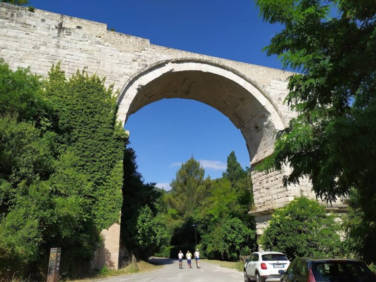
Arco di Traiano (Arch of San Damiano)
The Arco di Traiano, also known as the Arch of San Damiano, originally consisted of three marble-clad arches forming a monumental northern entrance to the city. Constructed during the reign of Augustus, only the central arch remains today. The arch’s marble facing and architectural design signify its symbolic role in marking the city’s boundary along the Via Flaminia.
Funerary Monument (Tumulus)
A large funerary monument, extensively restored, is attributed to an aristocratic family, possibly the Furia family. A plaque from this tumulus is preserved in the museum at Palazzo Cesi in Acquasparta. The monument’s scale and decoration indicate the prominence of the family within Carsulae’s social hierarchy.
Funerary Monument (Necropolis)
A less elaborate funerary monument is located within the necropolis surrounding Carsulae. The necropolis contains tombs dating from the late Republic through the early Imperial period, including both inhumation and cremation burials marked by stone cippi and sarcophagi fragments. Some tombs bear inscriptions providing personal names and family information.
Excavation and Research
Initial excavations at Carsulae were sporadic and unstructured, beginning in the 16th century under Duke Federico Cesi, who sought decorative architectural elements for his palace in Acquasparta. Systematic archaeological investigations commenced in 1783 under Count Sebastiano Graziani of Terni during the papacy of Pius VI. A catalog of early finds was compiled by A. J. Milli in 1800.
Modern, methodical archaeological exploration began in 1951 under Umberto Ciotti, then superintendent for Umbria, with significant additional work conducted in 1972. Key publications include Ciotti’s “Carsuale” (1976) and the edited volume “Carsulae I. Gli scavi di Umberto Ciotti” by Paolo Bruschetti, Luca Donnini, and Massimiliano Gasperini. Excavations resumed in 2004 at the Roman baths under inspector Paolo Bruschetti and Prof. Jane Whitehead (Valdosta State University), in collaboration with the Associazione per la Valorizzazione del Patrimonio Storico San Gemini. From 2020, Prof. Elizabeth Colantoni (University of Rochester) was expected to continue work at the baths. Current Italian-led excavations are directed by Massimiliano Gasperini and Luca Donnini.
Preservation and Current Status
The ruins of Carsulae are generally well-preserved due to the site’s abandonment in the 6th century CE and limited subsequent disturbance. The Via Flaminia’s basalt pavement and several public buildings retain substantial structural elements, although many walls are partially collapsed. The theatre’s seating area and the forum’s porticoes survive in fragmentary condition, with some columns fallen but remaining on site.
Restoration efforts during the 20th and 21st centuries have focused on stabilizing key structures, including the forum basilica and the hypocaust system of the baths. These interventions employ modern materials to support original masonry without extensive reconstruction. Some areas, such as the necropolises, remain largely unexcavated and are preserved in situ. Vegetation growth and erosion present ongoing challenges, addressed through regular maintenance by heritage authorities.
Public access pathways and informational signage have been installed to facilitate scholarly study and controlled visitation. Excavations continue intermittently under the supervision of the Italian Ministry of Culture, emphasizing conservation and targeted exploration rather than large-scale excavation.
Unexcavated Areas
Significant portions of Carsulae remain unexcavated, particularly in the northern and eastern sectors beyond the main urban core. Surface surveys and geophysical investigations have identified subsurface anomalies consistent with buried structures, including possible residential blocks and additional workshops. The necropolises along the main roads are only partially explored, with many tombs documented through surface finds but not fully excavated.
Modern agricultural use and vegetation cover limit excavation in some areas. Current conservation policies prioritize preservation over intrusive investigation, with future archaeological work planned to focus on targeted areas identified through non-invasive methods. This approach aims to balance research objectives with the protection of the site’s integrity.
Nearby sites