Cáparra: A Roman Municipium in Spain
Table of Contents


Visitor Information
Google Rating: 4.5
Popularity: Medium
Google Maps: View on Google Maps
Country: Spain
Civilization: Roman
Remains: City

Context
Cáparra is situated near the modern Autovía A-66, close to exit 455 and the town of Oliva de Plasencia in the province of Cáceres, Spain. The archaeological site occupies a gently elevated plateau overlooking the surrounding plains, providing strategic views over adjacent agricultural landscapes. It lies along the historic route known as the Vía de la Plata, a major Roman communication corridor traversing western Iberia from north to south. This ancient road alignment is reflected in the modern highway that follows much of the same trajectory.
Archaeological investigations have revealed evidence of earlier indigenous occupation during the Iron Age, preceding Roman control. While the most substantial material culture and urban remains date to the Roman Republican and Imperial periods, stratigraphic sequences indicate continued habitation into Late Antiquity. Over time, the site experienced a gradual decline, with archaeological layers documenting diminishing activity and eventual abandonment. Today, the visible remains consist primarily of foundation outlines, street patterns, and scattered architectural fragments exposed on the surface.
Systematic field surveys and excavations conducted since the twentieth century by Spanish archaeological teams have identified and partially uncovered the city’s layout and principal monuments. Artifacts such as ceramics, coins, and inscriptions recovered from the site contribute to understanding its role within the broader regional and imperial contexts of Roman Lusitania.
History
Cáparra’s historical trajectory exemplifies the transformation of western Iberia from indigenous settlement through Roman integration and urban development, followed by decline in Late Antiquity. Located along the vital Vía de la Plata, the city functioned as a key node in regional communication and administration within the Roman province of Lusitania. Its evolution from a local indigenous community into a municipium reflects the processes of Romanization and urbanization characteristic of the Iberian Peninsula. The city’s importance diminished after the third century CE, culminating in abandonment during the early medieval period following the collapse of Roman authority and the Muslim conquest.
Pre-Roman and Indigenous Period
Prior to Roman domination, the area encompassing Cáparra was inhabited by indigenous groups, most likely the Vettones or Lusitanians, as indicated by the city’s pre-Roman toponym and its position near their territorial boundary. The ancient geographer Ptolemy references a settlement named Kapasa in this region, which modern scholarship associates with Cáparra, situating it within Vetton lands, though some debate its Lusitanian affiliation. Although no definitive architectural remains from this period have been identified, ceramic fragments recovered from beneath Roman layers suggest the presence of an indigenous nucleus during the Iron Age. This early occupation laid the cultural groundwork for the subsequent Roman city.
Roman Conquest and Republican Period (1st century BCE)
Following the Roman conquest of the Iberian Peninsula, Cáparra was incorporated into the province of Lusitania, administered from Augusta Emerita (modern Mérida). Initially classified as a civitas stipendiaria, or stipendiary city, it was obligated to pay tribute and provide military levies to Rome while maintaining a degree of local autonomy. The city exercised self-governance through its own magistracies, minted coinage, and retained land rights. Its strategic location along the Vía de la Plata, a principal north-south artery, enhanced its role as a communication and commercial center within western Iberia during this period.
Roman Imperial Period and Municipium Status (1st–3rd centuries CE)
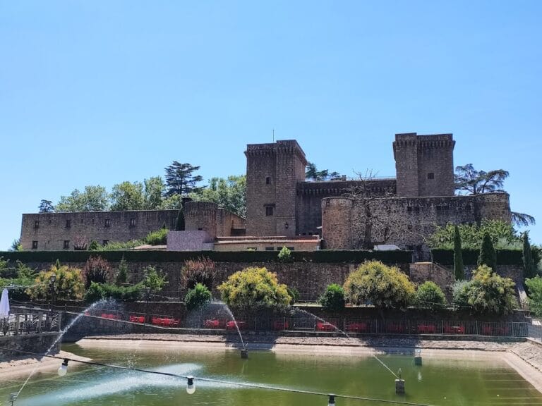
During the Flavian dynasty, likely following Emperor Vespasian’s Edict of Latin Rights in 74 CE, Cáparra was elevated to municipium status, granting its magistrates Roman citizenship and integrating the city more fully into the imperial administrative framework. This status is attested epigraphically and reflected in the adoption of a Roman orthogonal street grid centered on the Vía de la Plata, which functioned as the city’s decumanus maximus (main east-west street). The urban area was enclosed by stone fortifications covering approximately 15 to 16 hectares, although evidence of extramural housing to the northwest indicates a larger inhabited zone prior to the construction of the walls.
The city’s most distinctive surviving monument, the tetrapylon, was erected in the late first century CE. This unique four-sided arch marked the intersection of the cardo maximus and decumanus maximus near the forum and public baths. Commissioned by Marcus Fidius Macer, a prominent local magistrate, the arch originally stood over 13 meters tall and featured pedestals that likely supported statues. The public baths, also dating to the Flavian era, occupied a substantial complex northwest of the city center and were supplied by a reservoir located outside the urban perimeter.
Additional urban features included a paved decumanus maximus with an integrated drainage system, lined by commercial tabernae and affluent residences. An amphitheater was situated outside the southeastern city walls. An inscription dated to 198 CE honors Julia Domna, wife of Emperor Septimius Severus, demonstrating the city’s political allegiance and participation in the imperial cult. Cáparra was recognized as a significant urban center within Lusitania, mentioned alongside other important cities such as Caurium (Coria), Augustóbriga (Talavera la Vieja), and Egitania (Idanha-a-Velha).
Late Roman Period and Decline (3rd–5th centuries CE)
In the late third century CE, amid increasing regional instability marked by barbarian incursions and military desertions, Cáparra fortified its urban perimeter with stone walls. These defenses enclosed a reduced area compared to earlier phases, reflecting a contraction of the inhabited space. Despite these measures, the city’s prominence waned over subsequent centuries. Inscriptions on milestones along the Vía de la Plata document road repairs under emperors including Trajan, Hadrian, and Maximian, indicating the continued importance of this route even as urban activity at Cáparra diminished.
Archaeological stratigraphy reveals a progressive decline in construction and occupation after the late Roman period. The city’s population and economic vitality decreased, and by the early medieval period, following the Muslim conquest of the Iberian Peninsula, Cáparra ceased to function as an urban center. Medieval sources, such as the 12th-century Codex Calixtinus, list Cáparra among depopulated cities, confirming its abandonment. The former urban territory was subsequently divided between noble and royal jurisdictions, fragmenting its administrative coherence.
Christian Period and Post-Roman Use
Following the Christian reconquest, a religious building dedicated to the Virgin of the Beautiful Flower (Virgen de la Bella Flor) was established near the tetrapylon, possibly reusing Roman foundations. The precise date and location of this structure within the city remain uncertain. By the eighteenth century, only a small rural population persisted, primarily innkeepers and farmers under the jurisdiction of nearby Guijo de Granadilla. The construction of modern infrastructure, including the N-630 road in the nineteenth century and a twentieth-century railway, further marginalized the site, leading to its final abandonment.
Modern Rediscovery and Archaeological Research
The site of Cáparra was identified in the twentieth century through surface remains and systematic archaeological surveys. Initial excavations conducted in 1929 uncovered key monuments such as the tetrapylon, amphitheater, and city walls. Subsequent archaeological campaigns, particularly since 1988 under the auspices of the University of Extremadura, have revealed public baths, domestic quarters, commercial tabernae, and sections of the Roman road within the urban area. The tetrapylon was declared a historic-artistic monument in 1931 and is currently protected as a Bien de Interés Cultural (Cultural Interest Asset). Ongoing research continues to refine understanding of the city’s urban layout and its role within Roman Lusitania.
Daily Life and Importance by Period
Roman Conquest and Republican Period (1st century BCE)
During the initial Roman annexation, Cáparra’s population likely comprised indigenous Vetton or Lusitanian inhabitants alongside Roman officials and settlers. Social organization included local elites and magistrates responsible for managing tribute and military obligations to Rome. Artisans, farmers, and small-scale traders formed the broader community. Archaeological evidence, including inscriptions, attests to an organized municipal structure overseeing civic duties.
Economic life centered on agriculture, with cultivation of cereals, olives, and exploitation of local fish and game resources. Artisanal production is indicated by ceramic assemblages and coinage, suggesting household-level craft and commercial exchange. Markets likely operated near the main thoroughfare, facilitating trade along the Vía de la Plata. Religious practices combined indigenous cults with Roman deities, although no temples from this period have been definitively identified. The city functioned primarily as an administrative and tributary center within the provincial system.
Roman Imperial Period and Municipium Status (1st–3rd centuries CE)
Following elevation to municipium status, Cáparra experienced demographic growth and increased Romanization. Citizens held Latin rights, and local magistrates were enrolled in Roman tribes such as the Quirina. The social hierarchy included a municipal elite exemplified by figures like Marcus Fidius Macer, whose inscriptions document multiple magistracies and civic benefactions. The urban population encompassed artisans, merchants, tavern keepers, and farmers.
Urban life revolved around the orthogonal street grid centered on the Vía de la Plata, which served as the decumanus maximus. Excavations reveal paved streets with drainage systems, lined by tabernae and affluent houses featuring mosaic floors and painted walls. The public baths complex was a focal point for hygiene and social interaction, supplied by a reservoir outside the city. Diet was varied, including bread, olives, fish, and imported goods accessed through trade networks.
Markets thrived in the forum area, with shops vending foodstuffs, pottery, and textiles. Transport involved animal-drawn carts and pedestrian traffic along paved streets and regional roads. Religious life included imperial cult worship, as evidenced by inscriptions honoring Julia Domna and public monuments such as the tetrapylon. The amphitheater hosted social and entertainment events, reinforcing communal identity. Cáparra functioned as a significant administrative center managing local governance, justice, and economic exchange within Lusitania.
Late Roman Period and Decline (3rd–5th centuries CE)
Amid growing instability, Cáparra’s population contracted and social structures shifted toward defensive priorities. The construction of stone walls reflects concerns over barbarian raids and military desertions. The municipal elite likely diminished, while remaining inhabitants focused on sustaining essential economic activities, including agriculture and limited artisanal production.
Urban maintenance declined, with fewer new constructions and reduced upkeep of public buildings. Archaeological evidence indicates simplification of domestic interiors and contraction of commercial activity. Although the Vía de la Plata remained vital for regional communication, local markets and transport diminished. Religious practices persisted but with less monumental expression; the imperial cult waned following political fragmentation. The city’s administrative role weakened, and by the early medieval period, it ceased to function as a municipium. Its territory fragmented between noble and royal jurisdictions, reflecting the loss of centralized civic authority. Daily life became rural and dispersed, centered on subsistence farming and small-scale trade.
Christian Period and Post-Roman Use
Following the Christian reconquest, the urban fabric was largely abandoned, with only a small rural population remaining. A religious building dedicated to the Virgin of the Beautiful Flower was established near the tetrapylon, possibly reusing Roman foundations, indicating continuity of sacred space but a shift in religious focus. The structure’s precise layout and date remain uncertain.
Daily life centered on agricultural labor and pastoralism, with few signs of urban occupation. The population included innkeepers and farmers, as recorded in eighteenth-century documents. The community was modest in scale and socially stratified, integrated into the jurisdiction of nearby Guijo de Granadilla. Transport and commerce were limited to local needs, and the site’s civic role was effectively nullified, transitioning from municipium to rural hinterland. Religious practices reflected Christian dominance, but no significant ecclesiastical infrastructure developed on the former urban scale.
Remains
Architectural Features
Cáparra’s urban plan is defined by a rectangular layout encompassing approximately 15 to 16 hectares, enclosed by stone fortifications dating to the late third century CE. These walls, measuring around 1,525 meters in perimeter, were constructed in response to increasing regional insecurity. The city occupies a raised plateau with elevations ranging from 380 to 408 meters above sea level, with the walls situated near 255 meters elevation. Archaeological evidence indicates that prior to the construction of the walls, residential areas extended beyond the northwest boundary, suggesting a larger inhabited zone during earlier phases.
The street network follows a Roman orthogonal grid centered on the intersection of the cardo maximus and decumanus maximus, the principal north-south and east-west axes. The decumanus maximus, aligned with the ancient Vía de la Plata, is paved with polygonal granite slabs and incorporates a drainage system. The cardo maximus intersects it at the city center near the tetrapylon. The urban fabric includes public, residential, and commercial buildings arranged along these main streets, with porticoes and tabernae lining the decumanus.
Key Buildings and Structures
City Walls
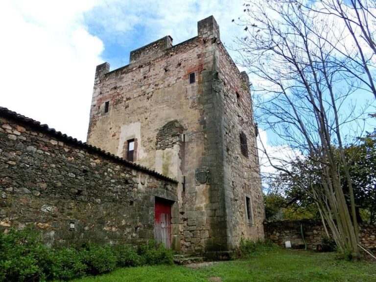
The city’s defensive walls were erected in the late third century CE using stone masonry techniques. Enclosing roughly 15 to 16 hectares, the walls form a roughly rectangular circuit around the urban core situated on a small promontory. Archaeological surveys have identified gates and towers integrated into the fortifications, although many sections survive only as foundations or low remnants. The walls represent a contraction of the inhabited area compared to earlier phases when houses extended beyond the northwest boundary.
Tetrapylon (Arco)
The tetrapylon is Cáparra’s most prominent surviving monument and the only known quadrifrons (four-sided) arch of its kind in Spain. Constructed in the late first century CE during the Flavian period, it stands at the intersection of the cardo maximus and decumanus maximus in the city center. The arch measures approximately 8.60 by 7.35 meters in plan and originally rose to about 13.30 meters in height. It consists of four pillars supporting four semicircular arches, each adorned with archivolt moldings around the intrados (inner curve of the arch).
Each pillar rests on a base topped by a prominent cornice. The north and south facades feature two attached pedestals per side, which likely held statues representing local notable couples mentioned in inscriptions. Inscriptions on the south front right pillar record that Marcus Fidius Macer, a local magistrate, commissioned the arch in fulfillment of his parents’ will. The tetrapylon is surrounded by the forum, public baths, and other main urban monuments. It was declared a historic-artistic monument in 1931 and is protected as a Cultural Interest Asset.
Public Baths (Thermae)
The public baths occupy the northwest corner of the city, adjacent to the decumanus maximus (Vía de la Plata). Constructed in the Flavian period, around the late first century CE, the baths have a roughly square plan measuring about 33 meters north-south by 36 meters east-west. The central bathing rooms are flanked by annexed chambers on both sides. To the south lies the palestra, an open exercise yard, while the north side contains several tabernae, possibly used for wood storage or administrative functions.
Access to the baths was from the west via a street parallel to the cardo maximus. Water was supplied through a ceramic pipe channel running along the decumanus sidewalk to a fountain in the palestra. No natural springs have been found within the city; water likely came from the Casa Blanca reservoir located south of the urban area. The baths include typical features such as heated rooms, though specific details of the heating system remain unclear.
Amphitheatre
The amphitheatre lies outside the southeastern city walls. Built with two concentric oval stone walls filled with earth, these supported the spectator seating area. Excavations since the 1960s have revealed its structural layout, though much of the seating and superstructure survive only in fragmentary form. The amphitheatre’s design follows typical Roman models, with an arena enclosed by the oval walls and access points for spectators. It is situated beyond the main urban enclosure, consistent with Roman urban planning conventions.
Forum Area
The forum was located near the tetrapylon and public baths at the city center. It included a curia (council chamber) and a civil basilica on the southern side. The decumanus maximus, approximately 5 meters wide, ran through the forum and was paved with polygonal granite slabs featuring a water drainage system. Principal public buildings and the most luxurious houses faced this street. The ground floors of buildings along the decumanus housed numerous tabernae with porticoes about 2 meters wide, separated from the street by a low wall supporting columns. Entrances to houses interrupted this wall to allow access.
Residential Area
Excavations have uncovered domestic quarters near the forum and along the main streets, including houses and tabernae. Many residences were also located outside the city walls in the northwest suburb area, indicating a more extensive inhabited zone before the late third-century fortifications. The houses vary in size and construction, with some showing evidence of multiple rooms and courtyards. The residential architecture primarily employs stone foundations and walls, with some use of brick and mortar.
Christian Religious Building
Following the Christian reconquest, a religious building dedicated to the Virgin of the Beautiful Flower (Virgen de la Bella Flor) was established near the tetrapylon. The exact date of construction and precise location within the city remain uncertain. Archaeological evidence suggests the building may have reused Roman foundations, but details about its architectural form and extent are limited.
Infrastructure: Roads
The decumanus maximus served as the main east-west street, aligned with the Vía de la Plata, and was paved with granite polygonal slabs. It included a drainage system to manage water runoff. The cardo maximus intersected the decumanus at the tetrapylon, forming the city’s principal crossroads. A segment of the Roman road has been excavated within the urban area, confirming the continuity of this communication axis. Secondary streets ran parallel and perpendicular to these main arteries, forming a grid pattern.
Other Remains
Three necropolises have been identified through excavations around the city perimeter. A reservoir known as Casa Blanca, located south of the urban area, likely supplied water to the baths and other facilities. Surface surveys and excavations have revealed remains of various buildings and urban features, including a second arch mentioned in historical documents but no longer extant. Approximately 500 meters north of the tetrapylon, a Roman double-arched stone bridge crosses the Ambroz river; this structure has been repeatedly rebuilt and restored over time.
Archaeological Discoveries
Excavations at Cáparra have uncovered numerous artifacts spanning from the Iron Age through Late Antiquity. Pottery fragments include locally produced ceramics and imported wares, primarily from the Republican and Imperial Roman periods. These include tableware, amphorae, and storage jars found in domestic and commercial contexts.
Inscriptions are a significant category of finds, notably those on the tetrapylon, which record local magistrates and dedicatory formulas. Additional inscriptions appear on milestones along the Vía de la Plata, documenting road repairs under emperors such as Tiberius, Nero, Trajan, Hadrian, Maximian, and the usurper Magnentius Decentius.
Coins recovered at the site span the Republican through Late Imperial periods, reflecting the city’s economic activity and political affiliations. Domestic objects such as lamps, cooking vessels, and furniture fragments have been found in residential areas, providing insight into daily life. Religious artifacts are less well documented but include altars and ritual vessels associated with the forum and temple areas.
Preservation and Current Status
The tetrapylon remains the best-preserved monument at Cáparra, with its four pillars and arches largely intact. It has undergone conservation and is protected as a Cultural Interest Asset. The city walls survive mainly as foundations and low sections, with some restored portions. The public baths and forum area are partially excavated, with structural remains visible but incomplete. The amphitheatre exists in fragmentary form, with earthworks and wall bases preserved.
Other urban features, such as streets and domestic buildings, survive as foundations and scattered architectural fragments. The Christian religious building’s remains are limited and not fully identified. Ongoing archaeological campaigns by the University of Extremadura and local authorities have stabilized many areas, though some remain unexcavated or only partially studied. No specific environmental or human threats are detailed in recent reports.
Unexcavated Areas
Several parts of Cáparra remain unexcavated or poorly studied. Surface surveys and geophysical studies suggest buried remains in peripheral zones, including additional residential quarters and possible economic or religious structures. The precise extent of these areas is not fully documented, and future excavations depend on conservation policies and land ownership. No detailed plans for large-scale excavation have been publicly announced, and some sectors are constrained by modern infrastructure developments nearby.
Nearby sites