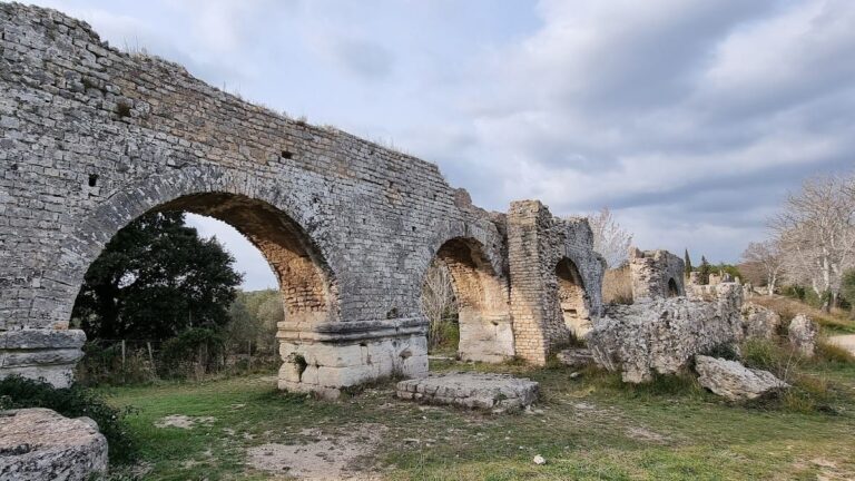
Pont-de-Crau: Roman and 16th-Century Aqueducts near Arles, France


Visitor Information
Google Rating: 4.9
Popularity: Very Low
Google Maps: View on Google Maps
Country: France
Civilization: Roman
Remains: Infrastructure

History
The Aqueduct of Pont-de-Crau is located near Arles, in the Provence region of southern France. It was originally built by the Romans in the 1st century AD to supply water to the city of Arelate, the ancient name for Arles. This aqueduct formed part of a larger water system drawing from the Alpilles mountains, with two main branches: One stretching 50 kilometers to the north and another 15 kilometers to the south, both meeting near the Roman water mills at Barbegal.
Following the decline of the Roman Empire, the aqueduct fell into disuse. Many of its stones were taken for other building projects, and the structure suffered significant damage during the First Crusade in the 11th century. By this time, only the foundations of the original aqueduct remained visible.
In the late 16th century, the foundations of the Roman aqueduct were repurposed for the Canal de Craponne, constructed between 1585 and 1587. This canal was designed to irrigate the surrounding lands and provide water to Arles. The canal extended westward from Salon-de-Provence to Arles, with its final section built directly atop the ancient Roman foundations. The name Pont-de-Crau reflects the combination of the Roman bridge (“pont”) and the nearby Crau plain.
The Canal de Craponne aqueduct was a notable engineering achievement of its time, built at a cost of 98,000 pounds. It featured a long masonry bridge with 93 arches spanning 660 meters. The structure required repairs in 1757 after flooding from the Rhône River caused damage. In the 20th century, the aqueduct ruins were officially protected as a historic monument in 1922. However, parts of the aqueduct were demolished in 1990 to make way for road construction near Arles.
Remains
The site includes remains of both the original Roman aqueduct and the later 16th-century Canal de Craponne aqueduct bridge. The Roman aqueduct was a two-level structure about 22 meters high. Its lower level served as a road crossing marshy land, while the upper level carried water. The Roman water channels measured approximately 1.15 by 0.90 meters on the northern branch and 1 by 0.80 meters on the southern branch. These channels joined near Barbegal before reaching Pont-de-Crau.
The 16th-century aqueduct bridge was constructed from stone masonry and featured 93 semicircular arches, extending 660 meters in length. Archaeological work during the canal’s construction uncovered the Roman aqueduct’s foundations, which were taller than those of the later canal bridge. Today, only three sections of the Canal de Craponne aqueduct remain visible: a central segment within a modern roundabout and two smaller sections beside the road.
The ruins have suffered partial destruction, notably in 1990 when several arches were removed to accommodate a traffic roundabout at the intersection of departmental roads near Arles. Despite this, the surviving sections still illustrate the scale and construction techniques of the 16th-century aqueduct. The site’s name, Pont-de-Crau, preserves the memory of the Roman bridge and its location on the Crau plain.
Nearby sites