Orikum Archaeological Park: An Ancient Coastal Settlement in Albania
Table of Contents


Visitor Information
Google Rating: 4
Popularity: Very Low
Google Maps: View on Google Maps
Country: Albania
Civilization: Byzantine, Greek, Ottoman, Roman
Remains: City

Context
Orikum Archaeological Park is situated near the contemporary town of Orikum in southwestern Albania, positioned along the eastern shore of the Adriatic Sea. The site occupies a strategic location at the interface between the coastal plain of the Bay of Vlorë and the rugged foothills of the Ceraunian Mountains. This topographical setting afforded access to maritime routes across the Adriatic as well as inland connections through mountainous terrain, factors that influenced settlement patterns and economic activities in the region.
Oricum was occupied from at least the Hellenistic period, with urban development continuing into the Roman imperial era. The site’s occupation appears to have diminished after the third century CE. The park preserves substantial architectural remains, including fortifications and public buildings.
History
Orikum Archaeological Park embodies a multifaceted historical trajectory shaped by its coastal position on the Adriatic, serving as a nexus between maritime and inland spheres. The site’s evolution reflects major regional processes, including Greek colonization, Hellenistic political formations, Roman imperial expansion, and Byzantine provincial administration. Over time, Oricum transitioned from a proto-urban Greek settlement to a Roman protectorate harbor, before experiencing a gradual decline as neighboring ports gained prominence. Its history is punctuated by episodes of political realignment, military engagements, and administrative transformations that link it to the shifting dynamics of the Illyrian coast and Epirus.
Pre-foundation and Archaic Period
Prior to the establishment of Oricum as a settlement, the surrounding landscape bears evidence of human presence dating back to the Late Paleolithic and Mesolithic periods, as demonstrated by finds at the nearby Rrëza e Kanalit rock shelter. During the Bronze and Iron Ages, Illyrian tumuli discovered in the Dukat hinterland exhibit architectural parallels with burial mounds in southern Italy, such as the Torre Santa Sabina tumulus in Brindisi, indicating cross-Adriatic cultural interactions. Grave goods recovered include Middle Helladic artifacts, Aegean-style knives, locally produced Minyan ware, and Naue II swords characteristic of Mycenaean culture around the 12th century BCE, underscoring extensive maritime connections with the Aegean and southern Italy. Imports from southern Italy appear in the Dukat plain by the 11th to 10th centuries BCE, suggesting sustained exchange networks. Although direct archaeological evidence is lacking, it is hypothesized that Euboean and Phoenician traders may have established early maritime routes along the eastern Adriatic coast, potentially including the future site of Oricum, continuing earlier Mycenaean seafaring traditions.
Oricum itself likely originated as a Greek colonial foundation in the 6th century BCE, possibly established as an Eretrian emporium or harbor. While literary sources propose an earlier Euboean presence in the 8th century BCE, archaeological data confirm occupation beginning in the 6th century BCE. The settlement developed as a proto-urban center facilitating trade between Greek merchants and indigenous Illyrian populations. Corcyrean commercial activity is attested by 5th and 4th century BCE coins from Korkyra (modern Corfu) found on site. By the mid-5th century BCE, Oricum expanded according to Greek urban planning principles. The earliest literary reference to Oricum as a polis appears in the mid-4th century BCE Periplus of Pseudo-Scylax, confirming its recognition within the Greek world.
Classical Period
During the Classical period, Oricum was likely incorporated within the peraia, or territorial possessions, of Corcyra, as recorded by Thucydides. A 5th century BCE oracular inscription from Dodona, written in the Corinthian alphabet, mentions a citizen of Oricum and refers to the city’s chôra (territory), indicating political and religious affiliations with the Epirote region. Linguistic evidence suggests the local dialect exhibited northwest Greek characteristics, inferred from inquiries made to the Dodona oracle. Around 450 BCE, the nearby polis of Apollonia expanded southward following its defeat of Thronium, possibly extending its influence toward Oricum. These developments situate Oricum within a contested political environment marked by shifting territorial control among neighboring poleis.
Hellenistic Period
In the early Hellenistic era, Oricum achieved autonomous polis status with its own territory, as evidenced by epigraphic records including a 4th century BCE sympoliteia (political alliance) with Corcyra. The city was incorporated into the Epirote kingdom under King Pyrrhus in the early 3rd century BCE. Unlike many contemporaneous urban centers, Oricum lacked defensive fortifications, likely due to its mountainous surroundings and amicable relations with neighboring groups such as the Chaonians, Apollonia, and Amantes. Burial customs evolved locally, with the appearance of Hellenistic brick-structured graves featuring false archways from the late 4th to 3rd centuries BCE, reflecting a distinctive funerary architectural tradition. During this period, Oricum was among the most prosperous cities in northern Epirus, contrasting with economic decline observed in southern coastal cities. The city’s ethnonym appears on 3rd century BCE decrees from Corcyra, oracle inquiries, and coinage, underscoring its political and cultural identity within the region.
Roman Period
Following Rome’s victory in the First Illyrian War in 228 BCE, Oricum became part of the Roman protectorate in Illyricum, alongside other key coastal cities such as Issa, Corcyra, Epidamnos, and Apollonia. This protectorate established Roman military and strategic control over the Adriatic littoral. In 214 BCE, Philip V of Macedon conducted raids along the Illyrian coast, briefly capturing Oricum and besieging Apollonia. The city requested Roman assistance and was promptly recovered by the Roman fleet under Marcus Valerius Laevinus. After Philip’s defeat, the region was divided between the independent kingdom of Pleuratus in the north and the Roman protectorate encompassing Oricum and other coastal settlements.
During the Roman civil war, Oricum initially supported Pompey but was the first city to surrender peacefully to Julius Caesar in 48 BCE upon his landing. Caesar’s account describes the inhabitants as Greek-speaking (“Graeci”), reflecting the city’s enduring Hellenic character. Oricum’s economy was based on natural resources from the nearby Acroceraunian Mountains, including timber for shipbuilding and limestone quarrying. These materials were transported to regional centers such as Apollonia and Dyrrhachium from the archaic period through Roman times. The city minted its own coins from approximately 230 to 168 BCE bearing the Greek legend ΩΡΙΚΙΩΝ (“of the Oricians”).
In the late Republican and early Imperial periods, Oricum transitioned toward a predominantly civilian settlement. Notably, the 2nd century CE senator Herodes Atticus constructed a theater during his exile in the city, although this structure was later destroyed by an earthquake. Over time, Oricum’s prominence declined as the nearby port of Aulon (modern Vlorë) rose in importance. This shift is reflected in the omission of Oricum from the Roman Tabula Peutingeriana, which includes Aulon instead. Roman literary sources such as Virgil and Sextus Propertius mention the “Orician terebinth,” indicating the city’s continued recognition for local natural products during the imperial period.
Late Antiquity and Byzantine Period
In the medieval period, Oricum—referred to as Jericho —formed part of a Byzantine provincial unit together with Kanina and Aulon, known as Provincia Jericho et Caninon. This administrative division is documented in a chrysobull granted to Venice by Emperor Alexios III Angelos in 1198 CE. Archaeological evidence reveals that the city’s defensive walls were repaired during Byzantine times, indicating ongoing occupation and concern for fortification maintenance. The nearby Marmiroi Church, dating to the reign of Emperor Theodore I in the early 13th century, features a small domed hall supported by four Roman arches and contains fragments of Byzantine murals, attesting to continued religious activity in the area during this period.
Ottoman Period
During Ottoman rule, the harbor of Oricum was renamed Pashaliman, meaning “the Pasha’s harbor.” This designation persists today, referring to the lagoon and the adjacent Albanian naval base. Although the ancient urban center ceased to function as a city, the harbor area retained strategic maritime significance throughout Ottoman administration. The site’s role shifted from an urban settlement to a military and naval facility within the Ottoman provincial framework.
Daily Life and Importance by Period
Archaic Period
During the Archaic period, Oricum developed as a Greek colonial emporium, transforming previously uninhabited terrain into a proto-urban settlement. The population primarily consisted of Greek settlers, likely from Eretria or Corcyra, who established a community oriented toward maritime commerce. Social organization included local elites and merchant families responsible for managing trade networks. Urban planning followed Greek models, suggesting emerging civic institutions and administrative roles.
Economic activities centered on maritime trade and the exchange of goods such as pottery, metalwork, and foodstuffs. The site’s location facilitated access to sea routes and inland resources, supporting a mixed economy of trade and resource exploitation. Archaeological evidence indicates the presence of small workshops and artisanal production catering to local and export demands.
The diet likely comprised cereals, olives, fish, and imported Greek staples, while clothing adhered to Greek styles, including wool and linen tunics and cloaks suited to the Mediterranean climate. Domestic architecture, though not extensively excavated, probably featured simple layouts with courtyards and storage areas. Religious life involved worship of Greek deities such as Apollo Nomios, with sanctuaries dedicated to nymphs and the Moirai, reflecting cultural continuity with the Greek world.
Classical Period
In the Classical era, Oricum’s population remained predominantly Greek-speaking, maintaining close political and religious ties with Corcyra and Epirus. The presence of a 5th century BCE oracular inscription from Dodona indicates active participation in regional religious networks. The local dialect likely exhibited northwest Greek features. Social hierarchy included civic officials, merchants, and religious functionaries, with evidence of territorial administration.
The economy continued to rely on maritime trade, supported by Corcyrean coinage found at the site. Local crafts and resource exploitation persisted, sustaining both domestic consumption and export. The settlement expanded along Greek urban lines, suggesting more complex civic infrastructure and public spaces. Diet and clothing reflected Greek customs, with staples such as bread, olives, fish, and wine. Religious practices centered on Greek cults, with festivals and oracular consultations reinforcing social cohesion. Civic governance probably involved magistrates bearing titles such as prytanis or strategos, blending local Epirote and Corcyrean administrative traditions.
Hellenistic Period
Oricum’s elevation to autonomous polis status in the early Hellenistic period brought increased political self-determination and economic prosperity. The population remained largely Greek-speaking, integrated into the Epirote kingdom under Pyrrhus. Social stratification included local elites, artisans, and religious leaders. The absence of fortifications suggests peaceful relations with neighboring tribes.
Economic life flourished through exploitation of natural resources such as timber and limestone, supporting shipbuilding and construction in Oricum and neighboring cities. Workshops and quarries operated at a scale sufficient to supply regional demands. The city minted its own coins, underscoring economic vitality and civic identity. Diet continued traditional Mediterranean patterns, supplemented by local produce. Domestic architecture likely featured courtyards and brick-built houses, while funerary customs evolved with the introduction of brick graves featuring false archways, indicating local innovation in burial practices. Religious life included worship of traditional Greek deities, with sanctuaries and oracular consultations maintaining cultural continuity. Civic institutions functioned with enhanced autonomy, reflected in decrees and alliances.
Roman Period
Following incorporation into the Roman protectorate after 228 BCE, Oricum’s population comprised Greek-speaking inhabitants alongside Roman administrators and military personnel. The social structure included local elites, Roman officials, artisans, and laborers engaged in resource extraction and trade. Notable individuals such as senator Herodes Atticus contributed to civic life through monumental building projects.
Economic activities centered on timber harvesting for shipbuilding and limestone quarrying, with materials transported to major centers like Apollonia and Dyrrhachium. The city operated workshops and maintained a harbor facilitating maritime commerce. Coinage bearing Greek inscriptions continued until the late 2nd century BCE, reflecting sustained local identity. Diet incorporated Mediterranean staples—bread, olives, fish, and wine—while clothing combined traditional Greek styles with Roman influences. Domestic spaces featured public buildings such as a theater, constructed by Herodes Atticus, and private homes likely included mosaic floors and painted walls, though the theater was later destroyed by an earthquake. Markets supplied a variety of goods, both local and imported, accessed via sea routes and coastal roads. Religious practices persisted with Greek cults alongside emerging Roman deities, and public festivals continued. Civic administration adapted to Roman structures, with local magistrates overseeing municipal affairs. Over time, Oricum’s prominence declined as nearby Aulon rose, reflected in its omission from Roman itineraries.
Late Antiquity and Byzantine Period
In Late Antiquity and the Byzantine era, Oricum—renamed Jericho—maintained a reduced but continuous population engaged in agriculture, trade, and religious activities. The social composition included Byzantine officials, clergy, and local inhabitants. Archaeological evidence of repaired city walls indicates ongoing defensive concerns and organized civic maintenance.
Economic life focused on sustaining local needs, with small-scale production and trade within the Provincia Jericho et Caninon. The Marmiroi Church exemplifies religious continuity, featuring Byzantine architectural elements and mural decoration, suggesting an active Christian community. Diet and clothing adapted to Byzantine norms, with local agricultural products supplemented by imported goods. Transport relied on coastal shipping and inland routes connecting to regional centers. Religious life centered on Christianity, with ecclesiastical leadership playing a key role in community organization and cultural life. Administratively, Oricum functioned within the Byzantine provincial system, governed by imperial officials and ecclesiastical authorities. The city’s role shifted from a commercial hub to a provincial center with religious significance.
Remains
Architectural Features
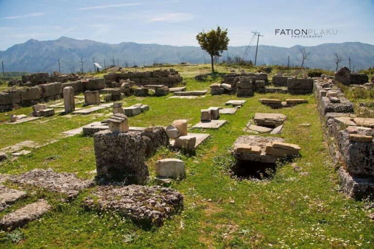
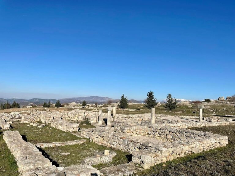
The archaeological remains at Orikum encompass structures dating from the Hellenistic through Byzantine periods, illustrating the city’s long-term occupation and evolving functions. The site’s urban layout includes defensive walls, public buildings, and religious installations constructed primarily of local stone masonry. Fortification walls, built with ashlar blocks, enclose portions of the settlement and demonstrate adaptations to the natural topography of the Ceraunian foothills. Evidence of Byzantine repairs to these walls indicates continued maintenance into the medieval period. Surface traces and architectural fragments are visible on land, while aerial surveys have identified submerged structures offshore, revealing the gradual coastal subsidence that affected the ancient harbor zone.
The architectural character of Oricum reflects a synthesis of Greek, Roman, and Byzantine influences, with construction techniques adapted to local materials and environmental conditions. The city’s expansion during the Hellenistic and Roman eras is evident in the scale and complexity of surviving remains, while later contraction and partial submersion have limited preservation in some areas.
Key Buildings and Structures
Monumental Fountain (Nymphaeum) and Cistern
The monumental fountain, initially misidentified as a theater, dates to the Roman period and functioned as a cistern for rainwater collection. It consists of a circular basin approximately 10 meters (33 feet) in diameter, constructed with masonry designed to retain water. This installation compensated for the absence of natural potable springs in the vicinity and formed a critical component of the city’s water management system. The fountain is situated near the religious precinct, indicating its integration within the urban and cultic landscape.
Unexcavated Temple
Directly beneath the monumental fountain lies an unexcavated temple whose architectural features and chronological attribution remain unknown. Its presence is inferred from the spatial association with the fountain and related finds, suggesting a religious complex in this sector of the city. Systematic excavation has yet to clarify the temple’s layout, function, or dedication.
Altar Dedicated to Dionysus
Excavations have uncovered a freestanding stone altar dedicated to the god Dionysus, located at some distance from the temple and fountain complex. Although its precise date is not firmly established, the altar’s characteristics align with Hellenistic or Roman religious practices. Its placement outside the main temple area indicates a dispersed pattern of cultic installations within Oricum.
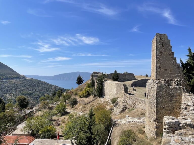
City Walls
Remnants of city walls encircle parts of Oricum, constructed primarily from local stone blocks. While the original fortifications likely date to the Hellenistic or early Roman period, archaeological evidence confirms repairs and reinforcements during Byzantine times, reflecting ongoing occupation and defensive concerns. The surviving sections are fragmentary, comprising low masonry courses and foundation remains that conform to the natural terrain, utilizing the foothills for additional protection.
Underwater Remains
A substantial portion of Oricum lies submerged offshore, as documented by helicopter surveys. These aerial observations have revealed outlines of houses and urban blocks beneath shallow waters, indicating gradual coastal submersion affecting the ancient harbor area. The underwater remains include building foundations and street patterns, which provide valuable data on the city’s original extent and maritime infrastructure despite limited excavation opportunities.
Marmiroi Church
The Marmiroi Church, situated near the ancient city, dates to the early 13th century CE during the reign of Byzantine Emperor Theodore I. The church comprises a small main hall measuring approximately 6 by 9 meters (20 by 30 feet) and features a dome about 3 meters (9.8 feet) in diameter supported by four Roman arches. The interior walls preserve fragments of Byzantine murals, indicative of liturgical decoration. The church’s masonry employs typical Byzantine construction techniques and attests to continued religious activity in the area during the medieval period.
Other Remains
Additional minor structures include scattered architectural fragments and foundation remains, but no further substantial buildings have been documented beyond those described above.
Nearby sites