Escolives-Sainte-Camille: A Gallo-Roman Villa and Merovingian Necropolis in Bourgogne-Franche-Comté, France
Table of Contents


Visitor Information
Google Rating: 4.6
Popularity: Low
Google Maps: View on Google Maps
Official Website: lavillascoliva.org
Country: France
Civilization: Celtic, Roman
Remains: Burial, City, Domestic, Economic, Infrastructure, Sanitation

Context
The Gallo-Roman site of Escolives-Sainte-Camille is situated in the Yonne department within the Bourgogne-Franche-Comté region of France. It occupies a gently inclined landscape near the Yonne River valley, approximately 10 kilometers south of Auxerre. This location provided advantageous access to fertile alluvial soils and a reliable water supply, factors that influenced the establishment and sustained occupation of the settlement during antiquity.
Positioned close to the ancient Via Agrippa—an important Roman road connecting Lyon to northern Gaul and Britain—the site was well integrated into regional communication and trade networks. Archaeological investigations have revealed a complex rural estate primarily active during the Roman period, with evidence of earlier Gallic presence and later Merovingian reuse. The site’s remains contribute valuable data on rural settlement patterns, agricultural practices, and socio-economic organization in Roman Gaul, while also illustrating continuity and transformation into the early medieval period.
Although the site experienced gradual decline by the late Roman era, no direct archaeological evidence links this to specific historical events or economic crises. Preservation of architectural elements varies, with some structures visible in situ and others known through excavation records. Local heritage authorities have implemented protective measures, and ongoing research continues to refine the understanding of the site’s role within the broader historical landscape of the Yonne region.
History
Escolives-Sainte-Camille presents a stratified record of human occupation spanning from the Middle Neolithic through the early medieval period. Its development reflects significant regional shifts in settlement, administration, and religious practice within north-central Gaul. The site’s transformation from prehistoric funerary landscapes to a prominent Gallo-Roman villa complex, and subsequently to a Merovingian burial ground, exemplifies the evolving political and cultural dynamics of the Yonne area under Roman and post-Roman influence.
Neolithic to Iron Age
Archaeological evidence attests to human activity at Escolives-Sainte-Camille beginning in the Middle Neolithic (circa 4500–2500 BCE). Excavations at the Pré de la Planche sector uncovered post holes, enclosure ditches, and burial features characteristic of this period, although these early habitation sites have been largely destroyed by later land use. A notable discovery is a Passy-type necropolis comprising approximately ten elongated funerary monuments arranged linearly, featuring tumuli and palisaded enclosures oriented east-west. This funerary architecture aligns with known ritual practices in prehistoric Burgundy.
During the Bronze Age (2300–800 BCE), the site yielded circular and quadrangular enclosures containing both cremation and inhumation burials, documented at Pré de la Planche and La Cour Barrée. The latter was identified during rescue excavations prior to gravel extraction in 1986. Iron Age presence is confirmed by Hallstatt and La Tène period burials and artifacts found beneath the later Roman villa remains. Despite these findings, no definitive indigenous farmstead predating the villa has been reconstructed, suggesting continuity of land use without clear evidence of permanent settlement structures from this era.
Gallo-Roman Period (Late 1st century BCE – Early 6th century CE)
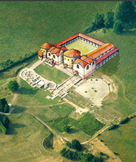
Following the Roman conquest of Gaul in the 1st century BCE, the territory encompassing Escolives-Sainte-Camille was incorporated into the province of Gallia Lugdunensis. The site developed into a substantial rural villa estate covering approximately four to five hectares, strategically located near the Via Agrippa, a principal Roman road established from 19 BCE that linked Lyon to northern Gaul and Britain. This proximity facilitated integration into imperial transport and economic networks.
The villa’s architectural plan centers on a large rectangular courtyard measuring roughly 40 by 20 meters, encircled by corridors granting access to residential and agricultural sectors. Excavations have revealed a well-defined pars urbana, including private dwellings and extensive thermal baths, alongside a pars rustica comprising a 200-meter-long paved street lined with small square buildings arranged in a U-shaped complex and enclosed by a perimeter wall. The baths, initially constructed in the early 1st century CE and significantly expanded in the late 3rd to early 4th century CE, employed a hypocaust heating system and featured two main sections: a smaller, private area for the villa owners and a larger section with a cold pool, likely rented to travelers on the Via Agrippa.
The foundations of the bath walls incorporate sculpted blocks repurposed from a nearby Gallo-Roman sanctuary. These blocks bear vegetal motifs such as acanthus leaves and grapevine foliage identified as “plant de César,” indicative of local viticulture in the 2nd century CE. Mythological iconography includes figures such as Silenus, griffins, sphinxes, sea monsters, and deities from both Greco-Roman and Gaulish pantheons, notably Apollo and Cernunnos. Wall paintings discovered in reception rooms include a prominent frieze approximately seven meters long, situated in a space overlooking the villa’s water source.
Palynological and archaeobotanical analyses demonstrate early anthropogenic landscape modification, with evidence of orchards, vineyards, and cereal cultivation surrounding the estate. Smaller religious monuments, including four-deity pillars, votive stelae, and a funerary stele ensemble, were also recovered, though the provenance of some sculpted stelae remains uncertain. The villa remained occupied from the late 1st century BCE until the early 6th century CE, serving both residential and economic functions. Its baths likely accommodated both estate inhabitants and travelers, reflecting a dual role within the rural economy. Despite indications of decline in the late Roman period, no specific historical or economic causes for abandonment have been conclusively identified.
Merovingian Period (6th–8th centuries CE)
Following the villa’s abandonment in the 5th century CE, the site was repurposed as a Merovingian necropolis. Archaeological excavations have documented approximately 354 graves at the “Grippe-Soleil” and “Champ des Tombeaux” sectors. The cemetery comprises simple earth inhumations, around thirty stone sarcophagi, and probable wooden coffins. Grave goods, including fibulae, belt buckles, and glass beads, reflect the funerary customs and social differentiation of the period.
The necropolis was active from the late 6th through the 8th century CE, with burials located both north of the villa ruins and within the ancient structures themselves. Additional sarcophagi discovered near the church of Saint-Pierre and Saint-Paul suggest the presence of at least two distinct funerary zones rather than a single continuous cemetery. The toponym “Scoliua” appears in liturgical regulations from the episcopate of Bishop Aunaire (circa 585–592 CE), linking the site to one of the oldest parishes in the Yonne region. Some scholars propose that a private oratory within the villa complex was converted into a parish church by the late 6th century, indicating early Christianization and ecclesiastical organization at the site. This transformation reflects broader religious and administrative developments in post-Roman Gaul under Merovingian rule.
Modern Rediscovery and Excavation (1955–Present)
The site was initially noted in the late 19th century through the identification of Roman tile fragments by M. Quantin. The toponym “Escolives” was interpreted by Paul Lebel around 1950 as deriving from the Celtic root “Scoliva,” possibly referencing a sacred spring. The archaeological significance of the site became evident in 1955 when the uprooting of a walnut tree revealed Merovingian graves beneath older ruins, prompting amateur archaeologist Raymond Kapps to initiate systematic excavations.
Kapps, a professor at Lycée Jacques Amyot in Auxerre, directed excavations from 1955 to 1983, involving students, colleagues, and volunteers. He received training in excavation techniques from André Leroi-Gourhan of the CNRS. After Kapps’s death in 1984, historian Daniel Prost assumed leadership until 1989, uncovering major features including the Gallo-Roman water source with exceptionally preserved organic artifacts. Prost also organized extensive documentation and published numerous scientific articles. Following Prost’s sudden death in 1990, Pascale Laurent took over archival work and site promotion, collaborating with professional archaeologists and students to produce regular publications and develop educational programs.
Excavations ceased in 1998, with subsequent efforts focusing on study, publication, and conservation. The site is owned by the commune of Escolives and promoted by the Société Archéologique d’Escolives. It is open seasonally to the public, featuring visible foundations of the baths and some private villa rooms protected from weather. A permanent exhibition displays architectural fragments, sculptures, ceramics, toiletry items, and rare organic artifacts such as leather shoes and wooden ex-votos preserved by the water source. The site was designated a supplementary historic monument in 1992, underscoring its archaeological and cultural significance within the region.
Daily Life and Importance by Period
Gallo-Roman Period (Late 1st century BCE – Early 6th century CE)
During the Roman period, Escolives-Sainte-Camille functioned as a rural villa estate inhabited by a landowning family and their dependents. The social structure likely included the villa owners, tenant farmers, laborers, and possibly slaves, reflecting the hierarchical organization typical of Gallo-Roman rural settlements. Men primarily managed agricultural production and estate affairs, while women oversaw domestic responsibilities and may have participated in local religious practices. Family units were nuclear but connected within extended kinship networks common in rural Gaul.
Economic activities centered on diversified agriculture, as evidenced by palynological data indicating cultivation of cereals, vineyards, and orchards. The pars rustica’s small buildings along a paved street suggest workshops or storage facilities supporting farming and artisanal production at a household scale. The presence of thermal baths with hypocaust heating demonstrates technological sophistication and wealth, serving both residents and travelers on the Via Agrippa. This dual function highlights the villa’s role as an agricultural hub and a waypoint within regional trade routes.
The diet likely included bread from local cereals, wine produced from estate vineyards, olives and olive oil, and fish sourced from the nearby Yonne River. Clothing conformed to Roman provincial styles, with wool and linen tunics and cloaks, and leather sandals, some of which have been archaeologically preserved. Interior decoration was refined, featuring painted walls with a notable frieze and sculpted architectural elements depicting vegetal and mythological motifs. Religious life combined Greco-Roman and indigenous Gaulish elements, as indicated by sculptural representations of Apollo and Cernunnos, votive stelae, and small shrines, reflecting syncretic practices typical of rural Gaul.
Merovingian Period (6th–8th centuries CE)
Following the villa’s abandonment, the site’s function shifted to funerary and ecclesiastical purposes. The Merovingian necropolis reflects a rural community practicing inhumation burial customs with social differentiation evident in grave types and goods. Grave goods such as fibulae, belt buckles, and glass beads indicate gender-specific attire and personal adornment. The reuse of villa structures for burials suggests continuity of land use and local memory.
Economic life during this period was predominantly subsistence-based, with small-scale farming supporting the local population. The absence of substantial architectural remains implies a dispersed settlement pattern. Although trade and transport diminished compared to the Roman era, proximity to former Roman roads may have maintained some regional connectivity. The presence of at least two funerary zones, including near the church of Saint-Pierre and Saint-Paul, indicates emerging ecclesiastical organization.
Religious life was dominated by early Christianity, with the toponym “Scoliua” appearing in late 6th-century liturgical texts, linking the site to one of the oldest parishes in the Yonne region. Scholars suggest that a private oratory within the former villa was converted into a parish church, marking the Christianization of the site and the establishment of ecclesiastical authority. This reflects broader Merovingian trends of integrating former Roman estates into the Christian parish system. The site’s civic role transitioned from a rural estate to a funerary and religious center under ecclesiastical governance, emphasizing spiritual and communal functions over economic production.
Remains
Architectural Features
Escolives-Sainte-Camille encompasses a rural villa complex extending over approximately five hectares, situated on gently sloping terrain near the Yonne River valley. The principal architectural arrangement centers on a rectangular courtyard measuring about 40 by 20 meters, surrounded by corridors providing access to residential and service areas. Construction techniques include stone foundations and walls, with evidence of ashlar masonry and the reuse of sculpted blocks from earlier Gallo-Roman religious monuments. A paved street approximately 200 meters in length, lined with small square buildings arranged in a U-shaped complex and enclosed by a perimeter wall, defines the agricultural or service sector (pars rustica).
The complex integrates residential (pars urbana) and agricultural/service (pars rustica) components. The residential area contains private dwellings and extensive thermal baths, while the service sector comprises multiple small buildings likely used for agricultural processing or storage. Funerary monuments and religious structures, including votive stelae and pillars, are also present. After the villa’s abandonment, the ruins were repurposed as a Merovingian cemetery, with graves located both within and north of the ancient buildings.
Key Buildings and Structures
Villa Residential Area (Pars Urbana)
The residential sector, occupied from the late 1st century BCE to the early 6th century CE, is organized around a large rectangular courtyard approximately 40 meters long and 20 meters wide. Corridors encircle this courtyard, providing access to various rooms and functional spaces. Excavations have revealed stone foundations and floor layers of private dwellings. Wall fragments with painted decoration were uncovered, including a mural approximately seven meters long and one meter high, located in a reception room overlooking the villa’s water source.
This area includes the villa’s thermal baths, originally constructed in the early 1st century CE and substantially enlarged at the end of the 3rd to early 4th century CE. The baths reflect significant investment and were likely used by both villa inhabitants and travelers on the nearby Via Agrippa.
Thermal Baths
The thermal baths constitute the most substantial and well-preserved remains at the site. Their initial construction dates to the early 1st century CE, with major expansions in the late 3rd to early 4th century CE. The baths comprise two main sections: a smaller part probably reserved for the villa owners and a larger section featuring a sizeable cold pool separated from heated rooms by a paved hall.
The heating system employed hypocaust technology, involving underfloor heating. Three annex rooms are arranged sequentially, progressing from cold to warm to hot pools, concluding with a sauna. These rooms have apsidal (semi-circular) shapes. The bath walls rest on foundations made from reused sculpted blocks taken from a nearby Gallo-Roman sanctuary. Decorative friezes include vegetal motifs such as acanthus scrolls and grape harvest scenes, with grapevine leaves identified as a “plant of Caesar,” indicating 2nd-century viticulture in the region.
Additional frieze decorations depict mythological figures from Roman and Gaulish traditions, including Silenus, a griffin, a sphinx, a sea monster, and the gods Apollo and Cernunnos (a Gaulish deity with a stag’s head). Cornices are richly adorned with Roman motifs such as heart patterns, egg-and-dart designs, pearls, dentils, and floral caissons interspersed with metopes showing animals, plants, croziers, and human faces. The baths’ sculptural decoration represents a significant artistic element of the site.
Water Source and Captage
The Gallo-Roman water source, known as the “captage du Creusot,” supplied water to the entire villa complex. Excavations revealed exceptionally well-preserved organic objects due to the wet environment, including wooden items such as a boxwood comb, fragments of wooden planks, seeds, and leather shoes dating from the late 3rd to 4th century CE. The water source continued to provide water after the villa’s abandonment, contributing to the preservation of these organic artifacts.
Economic and Service Buildings (Pars Rustica)
Located east of the residential area, the pars rustica is organized along a paved street approximately 200 meters long, lined with small square buildings arranged in a U-shaped complex. Some buildings are connected by partitions, and the entire sector is enclosed by a perimeter wall. This area is interpreted as the villa’s agricultural or service sector, likely used for processing, storage, and ancillary activities. Modern habitation partially overlies this sector, limiting full excavation. Surface traces include low walls and floor layers associated with these agricultural buildings.
Sculptural Monument with Arcades
Architectural fragments from a large monument featuring arcades have been recovered and are displayed in the site’s permanent exhibition. The sculpted blocks mainly derive from the frieze and cornice of this arcade monument and depict vegetal motifs and mythological figures. Some sculptures represent Greco-Roman or Gaulish deities. The original location and function of this monument remain unknown, as no in situ remains have been conclusively identified.
Funerary Monuments and Stelae
A group of funerary stelae was found against a wall on the site. Most are unadorned, but three are sculpted. Two bear busts, while a third depicts a woman wearing three tunics and carrying a towel on her shoulder. The provenance and original placement of this sculptural ensemble remain uncertain.
Merovingian Necropolis
Following the villa’s abandonment in the 5th century CE, the site was repurposed as a Merovingian cemetery from the late 6th to the 8th century CE. Excavations uncovered approximately 354 graves in the “Grippe-Soleil” and “Champ des Tombeaux” areas, including simple earth inhumations, around thirty stone sarcophagi, and possible wooden coffins. The necropolis is located north of the villa ruins and also within the ancient structures themselves. Grave goods such as fibulae, belt buckles, and glass beads were common. Additional sarcophagi near the church of Saint-Pierre and Saint-Paul suggest at least two distinct funerary zones.
Other Religious Monuments
Smaller religious monuments have been found on the site, including two four-god pillars, two votive stelae, a votive altar, and fragments of larger monuments. These remains indicate a religious presence but are less well documented than the villa and baths. Their precise original locations and functions remain unclear.
Archaeological Discoveries
Excavations have yielded a diverse assemblage of artifacts spanning from the Neolithic through the Merovingian periods. Pottery includes local and imported wares, with amphorae and tableware primarily found in domestic and service areas. Metal objects such as fibulae, belt buckles, and tools reflect daily life and burial customs. Glass beads and vessels were recovered mainly from Merovingian graves, indicating personal adornment and funerary practices. Wooden artifacts, including a boxwood comb and plank fragments, were preserved in the waterlogged environment of the Gallo-Roman water source. Sculptural fragments from religious and funerary monuments depict Greco-Roman and Gaulish deities, vegetal motifs, and human figures. Wall paintings and decorative friezes from the villa’s residential rooms and baths provide evidence of artistic decoration and iconography.
Preservation and Current Status
The site’s remains exhibit variable preservation. Foundations of the villa’s baths and some private dwellings are visible and partially sheltered to protect them from environmental damage. The thermal baths retain substantial structural elements, including hypocaust heating systems and decorated wall fragments. Other architectural features, such as pars rustica buildings, survive mainly as low walls and floor layers, often overlain by modern constructions. The Merovingian necropolis graves have been excavated and documented, with some stone sarcophagi preserved. Sculptural fragments and funerary stelae are conserved and displayed in a permanent exhibition. Conservation efforts by local heritage authorities have stabilized the site, with some areas covered to prevent erosion. Excavations ceased in 1998, and subsequent work has focused on documentation, publication, and site protection. Vegetation and modern development pose ongoing challenges to preservation.
Unexcavated Areas
Several parts of the villa’s agricultural sector (pars rustica) remain only partially excavated, particularly where modern habitation overlaps ancient structures. Surface surveys and aerial photography suggest additional buried remains within the site’s five-hectare extent. Neolithic, Bronze Age, and Iron Age features have been identified nearby but are not fully explored within the main villa complex. Future excavations are limited by conservation policies and modern land use. No recent comprehensive geophysical surveys have been published, and some areas remain inaccessible. Research continues to focus on archival study and non-invasive methods to better understand the site’s full extent and stratigraphy.
Nearby sites