Harrows Scar Milecastle: A Roman Fortification on Hadrian’s Wall


Visitor Information
Google Rating: 4.6
Popularity: Very Low
Google Maps: View on Google Maps
Official Website: www.english-heritage.org.uk
Country: United Kingdom
Civilization: Roman
Remains: Military

History
Harrows Scar Milecastle, also known as Milecastle 49, is located along Hadrian’s Wall near the River Irthing in Gilsland, United Kingdom. It was constructed by the Romans beginning around AD 122 during the reign of Emperor Hadrian. This milecastle formed part of the original turf section of Hadrian’s Wall, which stretched from Bowness on Solway in the west to Harrows Scar. The turf Wall and its associated milecastle were built on a prepared flat base using layers of turf or cobbles.
Before AD 138, the turf Wall was replaced by a stone Wall in this area. The stone Wall near Harrows Scar deviated from the original turf line to connect with the Birdoswald fort, located about 400 metres to the west. At this time, the milecastle was rebuilt in stone with larger internal dimensions and a distinctive south gate. This gate was narrowed using a hard white mortar, a feature linked to early 3rd-century construction phases. A carved stone showing the Roman gods Mars and Victory was incorporated into the south gate.
The site likely remained in use until the late 4th century, serving as a strategic river crossing over the River Irthing. After the Roman period, the area became part of a tenement known as The Harrows by 1603. A post-medieval cottage and yard were established adjacent to the Wall, with foundations of this later building uncovered during excavations in 1956. The milecastle’s long history reflects its continued importance from Roman military use through to early modern settlement.
Remains
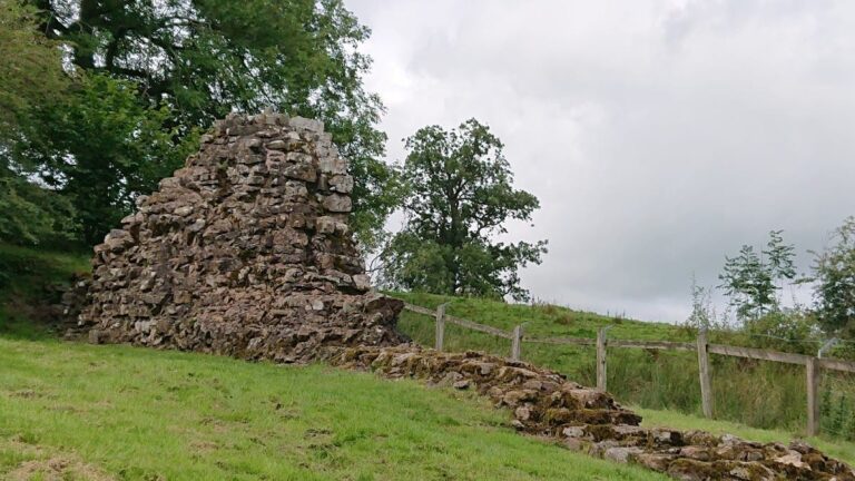
Harrows Scar Milecastle consists of two main construction phases: the original turf milecastle and the later stone milecastle. The turf milecastle was built with walls approximately 6 metres wide, enclosing an area about 14.5 by 15.2 metres. It was oriented with its short axis along the Wall and featured gates in both the north and south walls. The north gate included timber towers, typical of turf Wall milecastles.
The stone milecastle measures roughly 19.8 metres east-west by 22.9 metres north-south externally. Its narrow defensive walls are bonded to the stone curtain of Hadrian’s Wall on both sides. The stone milecastle features Type III gateways, with no visible remains of internal buildings, although timber structures are known from other turf milecastles. The south gate contains a carved stone depicting Mars and Victory, integrated into its structure.
A surviving stretch of the stone Wall between Harrows Scar and Birdoswald fort stands up to 2 metres high. This section preserves Roman inscriptions and phallic symbols carved into the stone. The milecastle lies just west of the River Irthing gorge, near the site of a Roman bridge at Willowford.
Two associated turrets were part of the milecastle’s defenses. Turret 49A was originally built with the turf Wall but was demolished during the construction of Birdoswald fort, leaving no visible remains. Turret 49B, located 340 metres west of Birdoswald’s west rampart, was excavated in 1911. Its masonry remains have been consolidated and exposed. This turret replaced an earlier turf Wall turret dismantled when the stone Wall was built. The site is protected today as a Scheduled Monument under English Heritage.
Nearby sites