Castle of Silves: A Historic Fortress in Algarve, Portugal


Visitor Information
Google Rating: 4.4
Popularity: High
Google Maps: View on Google Maps
Official Website: www.cm-silves.pt
Country: Portugal
Civilization: Medieval Islamic
Remains: Military

History
The Castle of Silves stands on a hill in Silves, Algarve, Portugal, on a site with a long history of occupation. Before the castle, the location may have hosted a Lusitanian castro, a type of fortified settlement. Archaeological evidence shows that Phoenicians, Greeks, and Carthaginians were present here before the Romans conquered the area around 201 B.C. Under Roman rule, Silves became an important commercial and military center.
Around 716 A.D., the Umayyad Caliphate took control of Silves. They strengthened the existing fortifications and expanded the castle and city walls. During the 11th century, Silves became the capital of a Muslim taifa kingdom ruled by Al-Mutamid. The castle and city defenses were further enhanced during the Almoravid and Almohad periods in the 12th and 13th centuries. The alcáçova, or citadel, was built at this time, serving both as a military fortress and a residence.
In 1189, King Sancho I of Portugal, supported by Crusaders, captured Silves after a long siege. However, Muslim forces under Amir al-Mu’minin retook the city in 1191. The castle remained under Muslim control until 1249, when Christian forces led by D. Paio Peres Correia conquered it during the reign of Afonso III. After the reconquest, Silves was granted a foral, or charter, in 1266, establishing its municipal rights.
During the 14th and 15th centuries, the city received royal privileges, including the appointment of Prince Henry the Navigator as alcalde (governor) in 1457. Despite these honors, Silves declined economically due to the silting of the Arade River and changing regional trade routes. The castle suffered damage from several earthquakes, notably the 1755 Lisbon earthquake.
The castle continued to serve military purposes into the 19th century, functioning as a garrison and powder magazine. It experienced periods of neglect and partial ruin, though some defensive walls remained in use during the Liberal Wars. Archaeological excavations began in the 19th century and intensified from the 1980s onward, uncovering important remains of the Muslim palace, baths, and cisterns. The site was declared a National Monument in 1910, with further protections added in 2012.
Remains
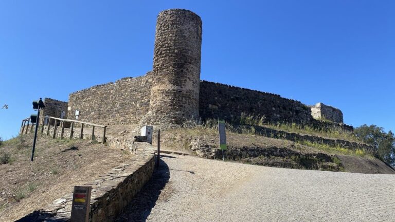
The Castle of Silves occupies a 56-meter-high hill overlooking the city and the Arade River. Its defensive complex includes three main parts: the alcáçova or citadel at the summit, the city walls enclosing the medina (old town), and a secondary wall protecting the suburban area known as the rabal. A fortified corridor called the couraça connected the walls to the river, ensuring water access.
The alcáçova is an irregular polygon with eleven square towers. Two of these towers, called albarrã towers, stand detached from the walls, while nine are attached. The towers have reinforced corners made of sandstone blocks. The walls and towers were built using military taipa, a form of rammed earth, faced with local red sandstone. The curtain walls feature battlements and a walkway about 388 meters long.
The main entrance to the alcáçova is a double door with an atrium, flanked by two towers. Nearby stands a bronze statue of King Sancho I. A secondary gate, the Porta da Traição, provided discreet access beyond the outer defenses. Inside the alcáçova lie the ruins of a two-story Almohad palace called the Palácio das Varandas, covering roughly 320 square meters. This palace included residential rooms, courtyards, two Umayyad-style bath complexes, and several gardens with porticos and upper galleries. Decorative elements such as marble, tiles, and stucco with geometric and vegetal motifs adorned the interiors.
The castle contains three cisterns for water storage. The largest, the cisterna da moura, measures 20 by 16 meters and stands 7 meters high. It is covered by four barrel vaults supported by twelve columns and could hold about 1.3 million liters of water. This cistern supplied much of the city until the late 20th century. Another cistern, the Cisterna dos Cães, is a vertical well over 40 meters deep connected to a reservoir.
The city walls are about 2.8 meters thick, built with taipa and faced with red sandstone. They are reinforced externally by a barbican wall. Seventeen towers defend the walls, including seven attached and ten albarrã towers linked by covered passages over arches. The city had three main gates, all protected by albarrã towers: Porta da Azóia to the northwest, Porta do Sol to the east (dated 1227), and Porta da Almedina, also called Porta de Loulé, which features a bent entrance formed by two albarrã towers. The Porta da Cidade near the Almedina Gate likely dates from the 14th century after the Christian reconquest.
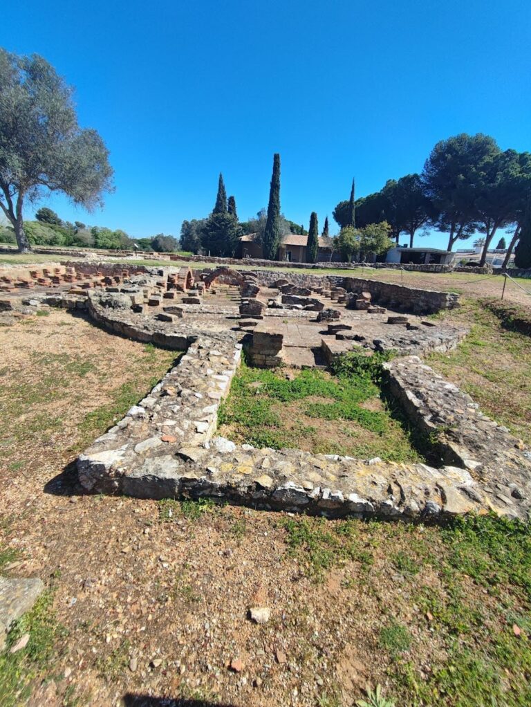
Archaeological finds include local and imported ceramics from Murcia, Tunisia, and Iran, glazed pottery, coins, and military artifacts such as arrowheads and crossbow bolts. A notable 12th–13th century ablution basin with stamped decoration is exhibited at the Louvre Museum. Near the alcáçova’s southwest side are ruins identified as the alcaidaria, the governor’s residence, and a rare 14th–15th century sugar mill, possibly linked to Prince Henry the Navigator.
The castle courtyard and surrounding areas have been adapted with visitor facilities, including a tea house built over original garden water channels. A botanical garden nearby features plants typical of Muslim gardens, such as pomegranate, fig, citrus, rosemary, mint, and sugarcane. Restoration efforts since the 1940s have stabilized and partially rebuilt walls, towers, battlements, and walkways, though some original palace ruins were lost during these works. Recent archaeological campaigns focus on preserving and interpreting the site’s rich history.
Nearby sites