Castle of Salir: An Almohad Fortress in Portugal


Site at a Glance
- Rating
- 3.9
- Popularity
- Low
- Country
- Portugal
- Primary era
- Medieval
- External website
- Open
- Eras represented
- Medieval
- Civilizations
- Almohad
- Site type
- Military
- Remains
- Castle
On this page13 sections
History
The Castle of Salir is a medieval military monument in Salir, Portugal, built as a late Islamic Almohad fortress during the twelfth century. The Almohads were a North African dynasty that ruled much of the western Islamic world, including the Algarve, during the twelfth and early thirteenth centuries. The fortress formed part of an inland defensive network and protected farmers and local inhabitants as Christian forces pressed into Muslim-held territory.
From rural settlement to Almohad fortress
Human occupation at Salir reaches back to prehistoric times, and Neolithic ceramic materials have been found at the site. During the Islamic period, the settlement began as a rural agricultural community, probably an alcaria, or village with dispersed houses beside cultivated holdings. Its inhabitants may have organized their own defense, perhaps around a structure that also served as a granary and contained several storage silos.
Archaeological evidence places occupation at Salir in the late eleventh or early twelfth century, with especially dense activity during the twelfth and thirteenth centuries. An earlier settlement and a funerary marker for Ibne Said, who died in 1016, were found south of the castle, probably within the former Muslim cemetery.
The fortress was constructed in the twelfth century as Christian pressure increased. The temporary Christian capture of Tavira by forces of the Order of Santiago, a military order involved in the Christian conquest and administration of Iberian territories, helped prompt the strengthening of inland defenses. Salir became part of an Almohad network extending from Castro Marim toward Alcoutim and functioned as a rural outpost protecting the surrounding population and routes between the coast and the interior.
Christian conquest and later medieval use
King Sancho I of Portugal conquered Salir in 1189, but Christian control was not definitive. The walls were reinforced toward the end of the twelfth century in preparation for Muslim counteroffensives. The castle was finally reconquered by the Order of Santiago at an uncertain date, probably between 1248 and 1250, shortly after the definitive capture of Tavira in 1242.
Paio Peres Correia is said to have used Salir as a camp while preparing operations against the fortresses of Loulé and Faro and waiting for the forces of Afonso III. Loulé and Faro were captured in 1249. After the Christian conquest, the castle was burned. Fire layers uncovered during excavation contained surviving weapon remains, while the former Islamic residential and military structures were later abandoned and destroyed. The castle was probably rebuilt twice before eventually falling into ruin.
From the fourteenth century, Salir lost military importance as the coastal regions became more strategically important. Objects from the thirteenth and fourteenth centuries show that activity continued at the site during part of this period. By the end of the sixteenth century, the castle was already abandoned and ruinous. The 1755 earthquake and subsequent rebuilding accelerated the destruction of the medieval complex. Several structures were demolished or reused, and surviving sections of the walls became part of later village buildings. Nineteenth-century descriptions reported that the deterioration was nearly complete.
Archaeology and interpretation
Archaeological research began in the 1980s. Initial study and clearance took place in 1986 under the coordination of António das Neves de Freitas Tavares, followed by excavation campaigns directed by Helena Maria Gomes Catarino from 1987 to 1998. Later work concentrated largely on preserving the remains and identified both military and residential structures.
The Salir Museum Interpretation Centre opened beside the ruins on 18 May 2006. Designed by Mário Varela Gomes, it was established within the excavated area. In 2024, the Algarve Regional Coordination and Development Commission and the municipality of Loulé proposed opening the process to classify the castle as a Monument of Public Interest. The formal classification procedure began on 11 October 2024, recognizing the castle as evidence of medieval Islamic and Christian defensive architecture and seeking its public acquisition and enhancement.
A local tradition connects the name Salir with the disappearance of the daughter of a Moorish governor called Aben-Fabilla. According to the legend, she remained in the castle when Christian forces threatened it and was transformed into a stone statue through her father’s intervention. The enchanted figure is said to reappear at the castle from time to time.
Remains
The Castle of Salir occupies the summit of a limestone hill at approximately 250 to 256 metres above sea level, where the Algarve Barrocal meets the Serra do Caldeirão. The southwestern slopes are relatively gentle, while the northern slopes descend more steeply. This elevated position provided broad visibility across the surrounding area and the valleys to the north and west. The castle also controlled inland corridors linking the coast with the Barrocal. The Roman archaeological site of Torrinha lies to the east, and the Castle of Paderne is approximately 16 kilometres away.
Defensive enclosure and towers
Walls and surviving circuit
The original enclosure had an irregular polygonal or oval plan and covered about 4,200 square metres. Its walls were built in taipa, or rammed earth, a construction method commonly used in Almohad fortifications. The walls were approximately 1.8 metres high and 2 metres thick and included a wall-walk. Square-plan towers stood on limestone foundations.
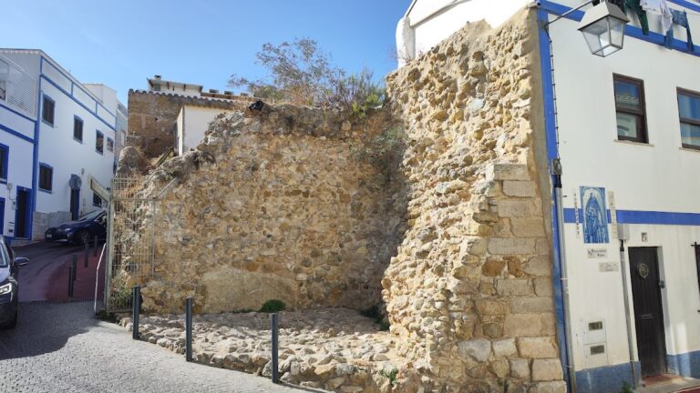
Four towers and two sections of curtain wall survive. Some parts of the defensive circuit were incorporated into later buildings. Two conserved wall sections are approximately 4.8 metres wide and survive to about 4 metres in height. One forms a northern section linking the northern towers; the smaller southeastern section is known as the Muro da Sabedoria.
Southwestern and northwestern towers
One surviving tower stands on the southwestern slope, enclosed within the walls of a later building beside a street that probably followed the southern side of the medieval enclosure. On the northwestern slope, the tower known as the Muro Maior projects beyond the principal defensive line. This type of external tower is called an albarran tower, a structure placed outside the main wall and connected to it by a wall or passage. Nearby are remains of a wall section and several buildings dating from the twelfth and thirteenth centuries.
Northern and northeastern towers
A third tower stands on the northern side, where rocky ground forms a pronounced slope toward the valley. It survives in an advanced state of destruction. The fourth tower, known as the Alfarrobeira, occupies the northeastern corner, where the terrain is also rocky and steep.
Entrance and residential quarter
Southern entrance and internal route
The principal entrance was probably on the southern side, toward the southeastern end of the enclosure. From this access, the internal route known as Travessa do Castelo ran westward and divided the castle courtyard. The route and the surviving wall sections help define the organization of the enclosure around its defensive perimeter.
Houses, courtyard, and storage facilities
Excavation inside the enclosure revealed an orthogonally planned residential nucleus. Six square houses were arranged around a central courtyard paved with stone slabs. The buildings were generally small and simply constructed in rammed earth over stone foundations. The group lay beside the northwestern side of the enclosure and probably formed a peripheral quarter.
The residential area contained kitchens with built hearths, ten silos, and former drainage or water-channel systems that emptied through small openings in the walls. A narrow street approximately 1.8 metres wide ended at one of the curtain walls. The remains preserve elements of daily domestic activity alongside the military structures, although the decay of the complex makes its original interior arrangement, lighting, and roof construction difficult to determine.
Archaeological materials and present interpretation
Excavations recovered ceramics from the twelfth and thirteenth centuries, together with glazed and unglazed pottery from the fourteenth and fifteenth centuries. Other finds include a decorated belt fitting, scissors, a knife, weapons, bone tools used in weaving, and decorative elements. Islamic-period wheat and acorn seeds were also recovered and were included in the 2017 exhibition Loulé: Territories, Memories, Identities at the National Archaeology Museum in Lisbon.
East of the Muro Maior, the excavated area forms an irregular rectangle containing kitchen and residential structures from the Muslim occupation. The Salir Museum Interpretation Centre stands within this area as a simple rectangular, single-storey building. Its main facade faces south toward the public access route and is reached by two flights of stairs. Around the ruins, paths are laid with Portuguese pavement, and garden beds were placed around the Muro Maior.