Castell de Vilarig: A Medieval Fortress in Catalonia, Spain


Visitor Information
Google Rating: 4.3
Popularity: Very Low
Google Maps: View on Google Maps
Official Website: www.poblesdecatalunya.cat
Country: Spain
Civilization: Unclassified
Remains: Military
History
Castell de Vilarig is situated in the municipality of Vilarig, Spain. This fortified site was constructed and developed during the medieval period under the influence of the local Catalan nobility.
The earliest record associated with the location dates back to the year 978, when Count-Bishop Miró documented a land grant in the settlement then called “villa Redi,” which was given to the monastery of Sant Pere de Besalú. Although the castle itself is not mentioned at this early stage, this record confirms the area’s importance during the late 10th century.
By the 13th century, the existence of the castle and its ruling family is clearly evident. Members of the Vilarig lineage appear in historical documents, including Ramon de Vilarig, who died in 1214 and held a religious office as prior of Santa Maria d’Ullà, and Joan de Vilarig, a canon in 1245. These mentions suggest that the fortress served as a noble residence linked to both secular and ecclesiastical roles.
In the early 14th century, marriage contracts highlight the continued prominence of the Vilarig family. In 1318, Ramon de Sagarriga married Elisenda, daughter of Jofre de Vilarig, establishing alliances that reinforced their social standing. A 1359 tax census records the castle and its surrounding territory, noting that 28 families lived under the jurisdiction of a knight, a mark of the castle’s local administrative importance.
Throughout the 14th and 15th centuries, the Vilarig lords maintained influential positions. Two abbots from the nearby Vilabertran community, Ermengol (1333–1347) and Gaufred (died 1403), are thought to have originated from this family, demonstrating ecclesiastical ties alongside their feudal authority. Around the early 1400s, Bernat de Vilarig is documented as playing a key role close to the king, indicating involvement at the royal court or military service.
Today, Castell de Vilarig is officially recognized as a cultural asset of national importance within Catalonia, reflecting its enduring historical relevance.
Remains
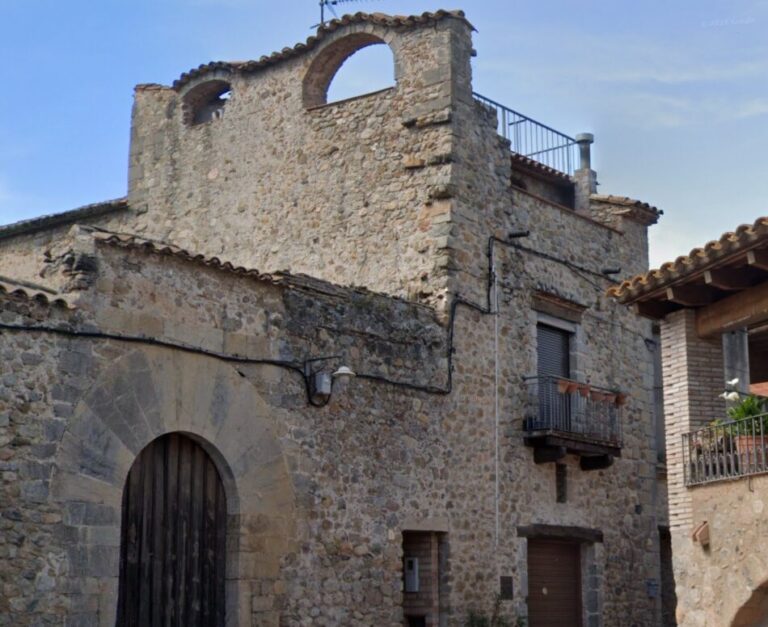
The castle of Vilarig presents a rectangular layout organized around a central open courtyard. Its primary façade faces east and is protected by ditches carved directly into the natural conglomerate rock, blending defensive engineering with the terrain. Surrounding the inner area is a protective wall strengthened by a talus, which is a sloping ledge made of small rounded stones bonded with mortar, creating a secondary barrier beneath the main fortifications.
Entry to the castle was secured by a lowered arch bridge crossing a moat, which led to the main doorway. This entrance features a semicircular arch crafted from finely hewn limestone blocks known as voussoirs, carefully arranged to form the curved opening.
The eastern wall preserves vestiges of narrow arrow slits designed for archers’ defense, alongside large rectangular windows styled in the Renaissance manner. These windows, identical in form, replaced earlier Gothic-style window openings at the top of the wall. A sculpted coat of arms framed with relief decoration surmounts the lintel above the main entrance, signifying the family’s heraldry.
Originally, the castle walls were topped with crenellations—the upright sections known as merlons and the gaps in between used for defense—but modifications have replaced the battlements with a roof. The spaces between the former merlons are now filled with masonry, while iron hooks from the original battlements remain visible, hinting at the earlier military design.
On the southern side, a later addition dating from the 17th or 18th century consists of a single-pitched roofed annex. This extension conceals the lower segment of the older wall, which rises above the annex’s roofline, showing the original stonework. The southern wall also retains battlements and traces of a machicolation, which is a projecting parapet fitted with openings allowing defenders to drop objects or pour substances onto attackers below.
The western façade exhibits older masonry crafted from roughly shaped pebbles laid in continuous horizontal layers. This section includes windows added during subsequent periods, reflecting alterations over time.
Along the northern wall, which lies adjacent to a church, the pebble masonry is combined with remnants of defensive features such as a machicolation, a stone corbel gallery (a series of projecting supports), and small arrow slits located near the top. Inside the courtyard, this same northern wall displays pronounced examples of “opus spicatum” or herringbone stonework, a technique where stones are arranged diagonally in a V-shaped pattern commonly used during the early Romanesque period.
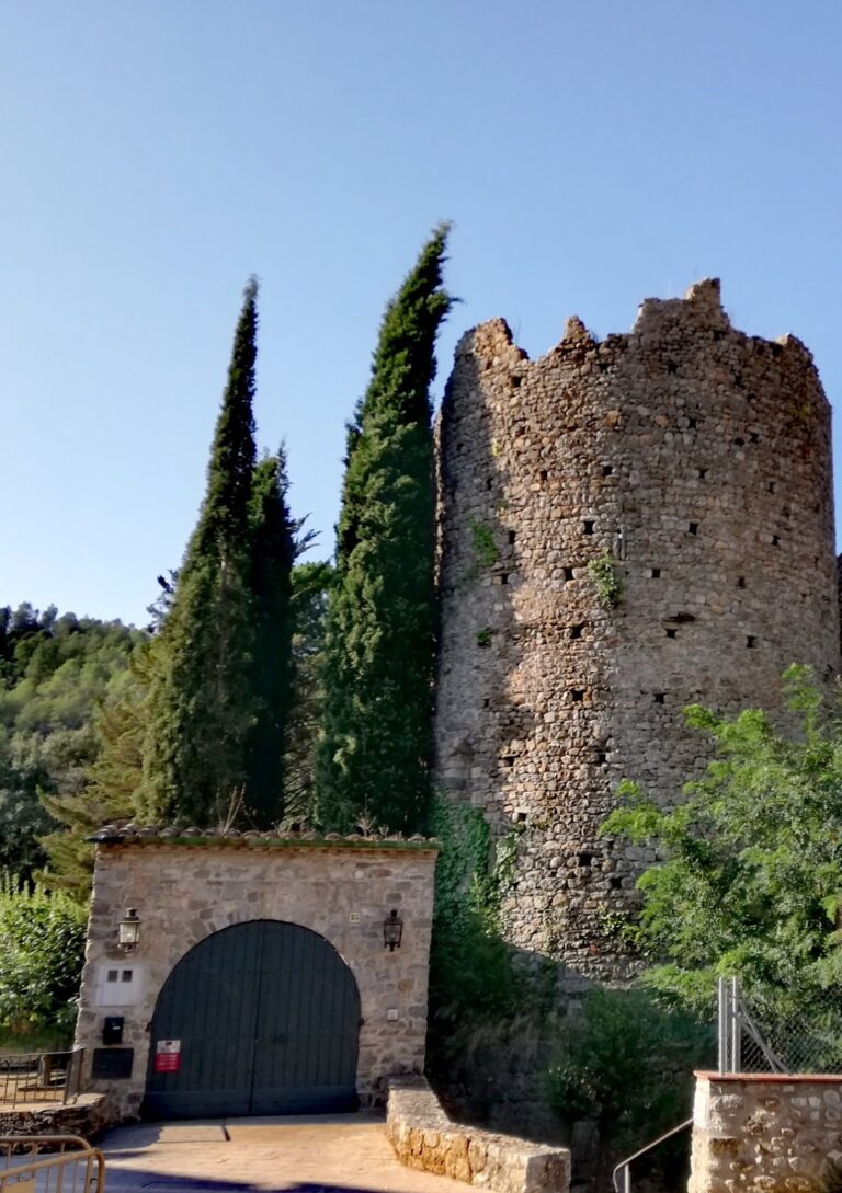
The area once serving as the outer bailey—a fortified outer enclosure—has since been repurposed into a threshing floor used for agricultural processing. Its boundaries remain clear through the surviving sections of the external curtain wall that formerly enclosed this space.
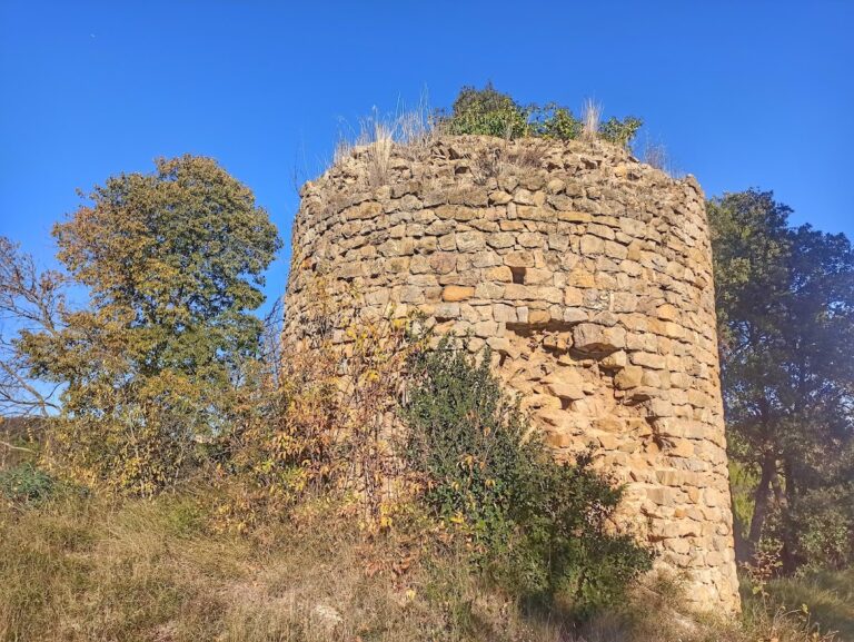
Wall heights vary throughout the castle. The northern wall segments reach approximately four to five meters, offering substantial protection. The eastern wall stands about three meters tall and contains a central gate marked by neatly dressed stone jambs framing the doorway. The southern wall is approximately two meters in height and features numerous arrow slits, indicating focused defensive use. Only a fragment of the western wall remains, near the southern corner; this piece is roughly three meters long and includes arrow slits as well.
The castle-palace incorporates elements of an earlier medieval fortress, with architectural components such as the courtyard’s herringbone stonework and the pebble masonry on the western wing dating to the early Romanesque era. These features attest to the long-standing occupation and gradual development of the site across centuries.
Nearby sites