Castello di Mariana Mantovana: A Medieval and Renaissance Fortress in Italy


Visitor Information
Google Rating: 4.2
Popularity: Very Low
Country: Italy
Civilization: Medieval European
Site type: Military
Remains: Castle
History
The Castello di Mariana Mantovana is located in the municipality of Mariana Mantovana, Italy. Its origins trace back to a medieval castrum, a type of fortified settlement built during the Middle Ages by local nobility. The earliest records of the site appear in the 11th and 12th centuries, with mentions in documents from 1033, 1054, 1104, and 1180. During this early period, the castle belonged to rural counts of Brescia and the palatine counts of Lomello, reflecting its function within the feudal landscape of northern Italy.
By the early 13th century, the castle is referenced in the Liber Potheris, a medieval document from the commune of Brescia. A 1215 record within this source describes the lands of Mariana and highlights essential defensive elements including a moat (referred to in Latin as fossatum castri), walls (murus castri), and storage facilities (caneva castri) inside the fortification. These features indicate the castle’s role as both a stronghold and a secure site for storing goods and supplies.
During the 15th century, significant developments occurred under the rule of Marquis Ludovico III Gonzaga, who in 1475 ordered the reconstruction of the castle as a Renaissance military fortress. The design work was entrusted to Giovanni da Padova, an architect responsible for adapting the medieval stronghold into a more modern defensive structure. This new phase included the construction of robust masonry elements and the introduction of a ravelin, an advanced outwork positioned before the main gate to improve the castle’s protection. An inscription dated 1466, bearing the Faroni family crest, is still visible near the castle entrance and supports dating the surviving fortifications to the mid-15th century.
Throughout the following centuries, the castle continued to be depicted in official maps from the 16th to 19th centuries, illustrating its unmistakable rectangular layout along with defensive moats and earthworks. These records show how the castle’s defenses evolved, with a second moat created to form a peninsula safeguarded by additional earth embankments. In the early 20th century, the original moat in front of the main tower was filled in, marking a shift in the site’s military relevance.
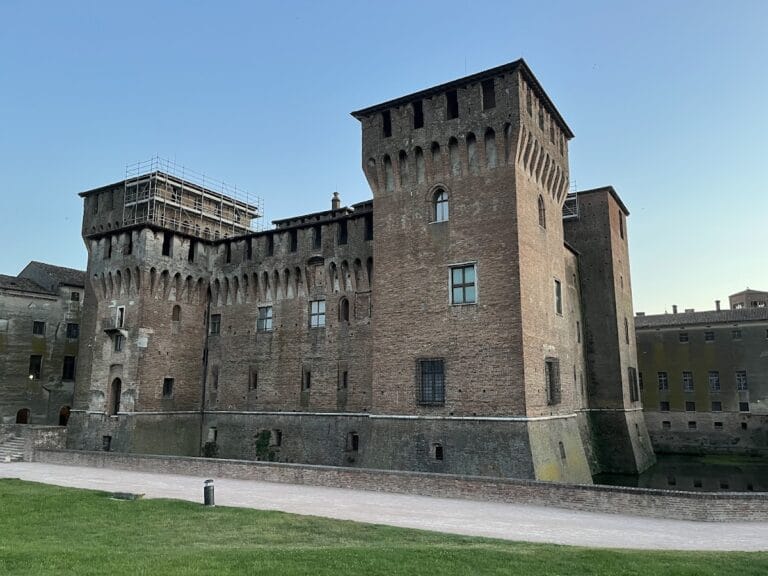
Remains
The Castello di Mariana Mantovana occupies a rectangular plot where the majority of its fortifications were constructed using earth and timber, while certain key features were built from masonry. This combination reflects common practices for fortresses on the Lombard plain, which often relied on earthen walls reinforced with wooden palisades safeguarded by water defenses.
Among the castle’s surviving structures, two prominent towers stand out. The bell tower, quadrangular in shape, remains partially intact and offers a glimpse into the castle’s past defensive and perhaps signaling functions. Close to it lies the gate tower, which retains the openings where drawbridge bolts once secured the entrance. This detail attests to the use of a movable bridge that spanned the moat, providing controlled access to the fortress.
The main gate complex occupied the southern side of the enclosure and included not only the carriage entrance but also a smaller pedestrian postern, both reinforced by the masonry tower. The presence of drawbridge bolt holes around these access points confirms the castle’s reliance on moats and drawbridges as defensive measures. Beyond the stonework, the remaining perimeter was formed by earth embankments crowned with wooden fencing, a practical arrangement typical of the period and region.
Outside the main gate stood a ravelin, an angular defensive work designed to shield the entrance from attack and equipped with its own surrounding moat. This feature, documented as early as 1461, demonstrates the castle’s adaptation to evolving military technologies of the late medieval era. Over time, the earthworks and water defenses shaped the castle’s distinctive layout, with later maps revealing a second moat that created a natural peninsula, which was further protected by strategically placed earth banks.
Today, aside from the towers and gate, the castle’s physical presence is largely defined by these remaining masonry elements and the traces of its historic earthworks. The 1466 inscription near the entrance, bearing the Faroni family emblem, remains a notable marker within the site, linking visitors to the fortification’s medieval heritage.
Nearby sites