Velia: An Ancient Greek and Roman City in Southern Italy
Table of Contents


Visitor Information
Google Rating: 4.4
Popularity: Medium
Google Maps: View on Google Maps
Official Website: museopaestum.cultura.gov.it
Country: Italy
Civilization: Greek, Roman
Remains: Burial, City, Civic, Domestic, Economic, Entertainment, Infrastructure, Military, Religious, Sanitation

Context
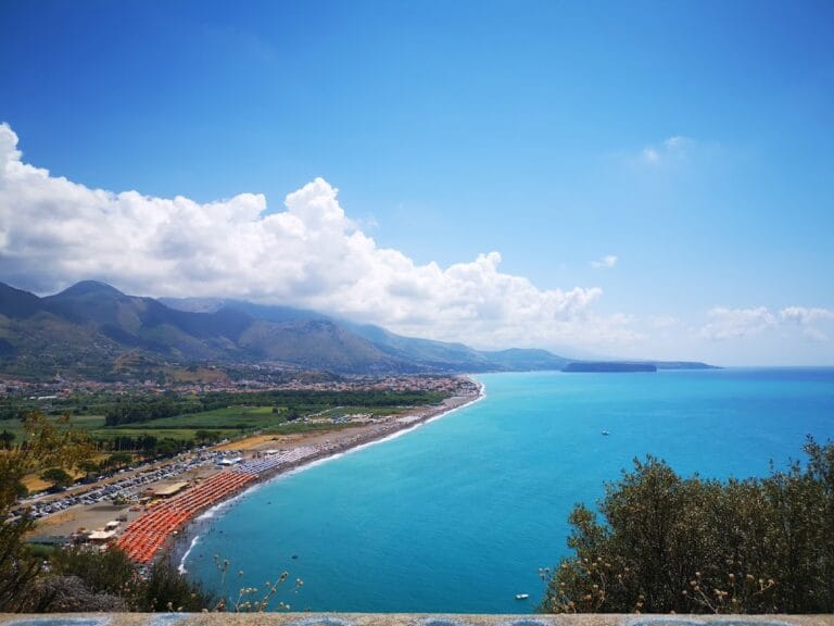
Velia is situated near the contemporary town of Ascea in the Campania region of southern Italy, positioned on a prominent coastal promontory overlooking the Tyrrhenian Sea. The site’s natural topography includes steep cliffs that provided defensive advantages and controlled access to maritime routes. Its location between the sea and fertile hinterlands allowed for a combination of agricultural exploitation and seaborne commerce, factors that shaped its settlement patterns and economic development throughout antiquity.
Founded in the late 6th century BCE by Greek colonists from Phocaea, Velia—originally named Hyele—occupied a strategic position within Magna Graecia. The settlement evolved through Classical and Hellenistic periods as a center of philosophical thought and cultural activity. Roman incorporation in the 2nd century BCE integrated Velia into imperial structures while allowing retention of certain local traditions. Archaeological investigations, initiated in the 18th century and continuing intermittently, have revealed substantial remains including fortifications, public edifices, and residential sectors. The site’s preservation benefits from its coastal cliffs and limited modern urban encroachment, with ongoing conservation efforts aimed at safeguarding its archaeological heritage and facilitating scholarly research.
History
Velia’s historical trajectory extends from its establishment in the mid-6th century BCE through its integration into the Roman Republic and Empire, culminating in decline and abandonment by the early medieval period. Founded by Greek settlers escaping Persian expansion in Ionia, the city developed into a notable polis distinguished by its philosophical school and maritime economy. Its coastal position fostered trade and political stability, while Roman rule introduced administrative changes and urban development. Environmental factors and infrastructural shifts contributed to its eventual decline, reflecting broader regional transformations in southern Italy.
Greek Colonization and Archaic Period (mid-6th century BCE)
In the mid-6th century BCE, Greek colonists from Phocaea, displaced by Persian military advances in Ionia, established the settlement initially known as Hyele on a promontory along the Tyrrhenian coast. This foundation followed the naval Battle of Alalia (circa 541–535 BCE), where Phocaean forces engaged a coalition of Etruscan and Carthaginian fleets. The colonists acquired the site from the indigenous Enotri population, naming it after a local spring. Archaeological evidence, including the recently excavated archaic temple dedicated to Athena on the acropolis, dated to approximately 540–530 BCE, attests to early religious and civic activity linked to the city’s foundation and military history. The settlers spoke a Doric dialect and employed an archaic Greek alphabet featuring the digamma (Ϝ), which influenced the evolution of the city’s name from *Welā to Hyele and subsequently Elea.
Classical Period (5th–4th century BCE)
During the Classical period, Elea emerged as a significant intellectual and cultural center within Magna Graecia, primarily due to the establishment of the Eleatic school of philosophy. Founded by Parmenides, who was born circa 510 BCE, the school emphasized metaphysical doctrines concerning the unity and immutability of Being, challenging sensory perception. Parmenides also played an active role in local governance, drafting laws and leading diplomatic missions, including one to Athens around 450 BCE to negotiate alliances. His successors, such as Zenon and Melisso of Samos, further developed Eleatic philosophy, contributing to its lasting influence. The city maintained stable political relations and commercial networks, supported by its two ports—one on the sea and another on the Alento river—and its natural defensive position. Unlike neighboring Poseidonia, Elea successfully resisted Lucanian expansion in the 4th century BCE through diplomatic skill and geographic advantages.
Roman Conquest and Administration (3rd century BCE – 1st century CE)
With the expansion of Roman power in southern Italy, Elea maintained amicable relations with Rome, providing naval support during the Punic Wars and participating in religious cults, notably by sending aristocratic priestesses to the sanctuary of Demeter. In 88 BCE, the city was formally incorporated as a Roman municipium under the name Velia, retaining privileges such as the use of the Greek language and the right to mint its own coinage. During the late Republic, Velia served as a naval base for prominent figures including Brutus in 44 BCE and Octavian in 38 BCE. The city experienced urban growth and prosperity into the 1st century CE, as evidenced by the construction of Roman baths, villas, and public buildings. However, the gradual silting of its ports, caused by sediment deposition from nearby rivers, and the construction of the Via Popilia, which bypassed Velia, contributed to its economic decline and relative isolation within the region.
Late Antiquity and Early Medieval Period
In late antiquity, Velia faced environmental challenges such as the encroachment of marshlands and the spread of malaria, prompting the population to concentrate within the fortified acropolis area. The settlement’s name evolved in medieval documents, reflecting its diminished status and changing political control. The territory came under the dominion of feudal families, including the Sanseverino in the 15th century and later the Royal House of the Annunziata of Naples. By the late 17th century, the ancient city was abandoned and largely obscured by marshes. Archaeological interest resumed in the 18th and 19th centuries, although early excavations sometimes damaged medieval layers. No substantial evidence indicates continued occupation beyond this period, marking the end of Velia’s urban history.
Daily Life and Importance by Period
Greek Colonization and Archaic Period (mid-6th century BCE)
The initial inhabitants of Hyele were Greek colonists from Phocaea who transplanted their Doric dialect and cultural practices to the site. The population likely consisted of kinship-based groups led by aristocratic families engaged in civic and religious leadership. Gender roles conformed to Greek norms, with men participating in public affairs and women managing domestic responsibilities, though women also held religious offices as priestesses, particularly in cults such as that of Demeter. The economy combined maritime trade, agriculture, and artisanal crafts. Fertile plains supported cultivation of cereals, olives, and vines, while the dual ports facilitated exchange with Greek and indigenous communities. Archaeological evidence of an archaic temple to Athena on the acropolis indicates organized religious activity. Domestic architecture probably featured courtyard houses with designated areas for storage and cooking. Dietary staples included bread, olives, fish, and locally produced wine, consistent with Mediterranean subsistence. Clothing comprised woolen tunics and cloaks, with sandals as common footwear. Literacy and administrative functions were supported by the use of an archaic Greek alphabet including the digamma.
Classical Period (5th–4th century BCE)
During the Classical era, Elea’s population remained predominantly Greek, with a well-established aristocracy that included philosophers such as Parmenides and Zenon, who also held civic offices. Family structures emphasized patriarchal authority, while religious roles allowed women public participation as priestesses. The social hierarchy encompassed landowning elites, artisans, and laborers contributing to the city’s economic and cultural vitality. Agriculture continued as the economic foundation, supplemented by maritime commerce through two ports enabling trade with Etruria and other Magna Graecia cities. Workshops producing pottery, textiles, and metal goods operated at household or small-scale levels. The agora and public buildings functioned as centers for political assembly and philosophical discourse. Dietary remains indicate continued reliance on cereals, olives, fish, and fruits. Clothing adhered to Greek styles, with wool and linen garments. Domestic interiors featured mosaic floors and painted walls, with courtyards and specialized rooms for storage and food preparation. Transportation relied on coastal navigation and overland routes. Religious life centered on temples such as the Athena sanctuary and Demeter’s cult, with festivals reinforcing communal identity. The Eleatic school’s rationalist philosophy influenced both local governance and wider Greek intellectual traditions. Elea maintained political autonomy through diplomacy and natural defenses.
Roman Conquest and Administration (3rd century BCE – 1st century CE)
Following incorporation into the Roman Republic, Velia’s population became more diverse, integrating Greek inhabitants with Roman settlers and officials. Civic administration adopted Roman municipal structures, including magistracies such as duumviri, while Greek language and cultural traditions persisted, as evidenced by bilingual inscriptions and continued coinage. Aristocratic families retained religious and political prominence. The economy aligned with the Roman market system, with agriculture focusing on olive oil and wine production for local and regional distribution. The city’s two ports supported naval operations during the Punic Wars and later military campaigns. Urban development included Roman baths, villas, and public buildings, reflecting prosperity and adoption of Roman architectural forms. Dietary practices incorporated Roman culinary influences alongside traditional Greek staples. Clothing adapted to Roman fashions, including tunics, togas, and stolas. Domestic interiors featured mosaic floors and frescoes, with spatial organization reflecting Roman domestic ideals such as atria and peristyles. Markets offered a variety of goods, including imported luxury items accessed via Mediterranean trade routes. Transportation combined coastal shipping with road networks, though the Via Popilia’s construction bypassed Velia, contributing to economic isolation. Religious practices blended Greek and Roman cults, with priestesses continuing roles in Demeter’s sanctuary. Velia functioned as a Roman municipium, retaining local autonomy within the imperial framework but facing economic challenges due to environmental and infrastructural changes.
Late Antiquity and Early Medieval Period
By late antiquity, Velia’s population contracted and concentrated within the acropolis to avoid expanding marshlands and malaria outbreaks. Urban complexity diminished, with fewer inhabitants and reduced economic activity. Social organization became localized, with feudal lords assuming control during the medieval period. Agriculture persisted on a subsistence basis, while maritime commerce declined sharply due to port silting. The city’s role shifted from municipium to a modest fishing village and feudal holding. Archaeological evidence for crafts and workshops is limited, reflecting economic contraction. Diet remained based on Mediterranean staples, though reduced trade likely limited access to imported goods. Clothing and domestic decoration during this period are poorly documented but likely simpler than in earlier eras. Religious life transformed under Christian influence, with pagan temples replaced by ecclesiastical structures. The settlement’s name changed in medieval documents, and its civic role diminished. Control passed to families such as the Sanseverino and later the Royal House of the Annunziata. By the late 17th century, Velia was abandoned, marking the end of its urban history.
Remains
Architectural Features
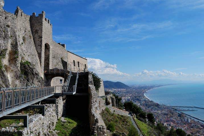
Velia occupies a coastal promontory originally surrounded by the sea, now an inland hill due to sedimentation from the Alento, Palistro, and Fiumarella di Santa Barbara rivers. This geological process caused the coastline to advance seaward and led to the silting of the ancient harbor area, leaving former ports situated hundreds of meters from the current shoreline. The city’s urban layout includes a fortified acropolis, two ports (one on the sea and one on the Alento river), residential districts, public spaces, and defensive walls. Construction techniques vary, with large ashlar masonry employed in fortifications and mixed stone and brickwork in later Roman structures. The urban fabric reflects a primarily civic and residential character, integrating religious and military elements. Over time, the city contracted, particularly in late antiquity, as marsh expansion and environmental changes reduced habitable areas.
Defensive structures combine natural cliffs with man-made fortifications. The acropolis was heavily fortified, especially during the medieval period, to protect remaining inhabitants from malaria and pirate raids. The city’s two principal gates, Porta Rosa and Porta Marina, controlled access and formed part of the defensive perimeter. Residential areas show evidence of continuous occupation from the Greek foundation through the Roman era, with expansions in the 1st century CE marked by the construction of villas and urban amenities.
Key Buildings and Structures
Acropolis and Archaic Temple of Athena
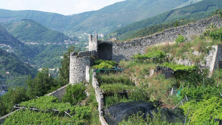
The acropolis crowns the promontory and contains archaeological evidence of a pre-Greek village, confirming earlier indigenous occupation consistent with Strabo’s account of an Enotrian settlement. Excavated in 2022, the archaic Temple of Athena dates to circa 540–530 BCE, shortly after the Battle of Alalia. Constructed with local stone, the temple’s remains include foundation walls and altar areas. The temple contained votive offerings, notably two helmets currently undergoing laboratory analysis for inscriptions that may clarify historical details about the warriors commemorated. In later periods, the acropolis served as a refuge, fortified with a substantial defensive structure known as Castellammare della Bruca. This fortification, visible today, was built to protect inhabitants from malaria and Saracen pirate raids and represents the final phase of settlement until the late 17th century.
City Walls and Gates
Velia’s defensive system capitalized on the promontory’s natural cliffs, supplemented by city walls constructed of large ashlar blocks. These fortifications enclosed the urban area and were maintained and modified from the Classical through the Roman periods. Two monumental gates survive: Porta Rosa, a well-preserved city gate featuring a vaulted passageway and large stone blocks, providing the main access to the archaeological site; and Porta Marina, located near the ancient port, which is less well preserved but still identifiable. Both gates regulated movement and formed integral components of the city’s defensive infrastructure.
Ports of Velia
Archaeological evidence confirms the existence of two ports: one opening directly onto the sea and another situated on the Alento river. Both ports were operational during the city’s peak but gradually became unusable due to sedimentation from nearby rivers. This process pushed the coastline outward, leaving the ancient harbor areas buried beneath alluvial deposits and distant from the modern shoreline. Remains include quay walls and harbor installations, though much is now obscured. The decline of these ports contributed significantly to Velia’s economic isolation in late antiquity.
Thermae (Baths)
Within the urban area are remains of public baths dating to the 1st century CE, reflecting the city’s prosperity during the Roman period. The complex includes rooms arranged for bathing functions such as heated chambers (caldarium), cold rooms (frigidarium), and changing areas (apodyterium). Construction materials comprise brick and stone, with evidence of hypocaust heating systems (underfloor heating). The baths are integrated into residential quarters, illustrating urban development and Roman architectural influence.
Agora
The Agora, serving as the city’s public square and marketplace, is partially preserved within the archaeological park. Remains include paved surfaces and foundation walls of surrounding porticoes or shops. The layout corresponds with urban planning principles typical of Magna Graecia settlements and reflects the civic and social functions of the space during Greek and Roman periods.
Residential Quarters
Excavations have identified two principal residential districts: the Southern Quarter and the Archaic Quarter. These areas contain domestic structures ranging from modest houses to larger villas. Architectural features include stone foundations, interior courtyards, and mosaic floors in some Roman-era buildings. The residential zones demonstrate continuous occupation from the city’s foundation through the 1st century CE, with evidence of urban expansion and increased wealth during the Roman period.
Via di Porta Rosa and Porta Marina
Porta Rosa is a monumental city gate constructed during the Classical period, characterized by large stone blocks and a vaulted passageway, providing controlled access to the city’s interior. Porta Marina, located near the ancient port, served as a secondary gate. Although less well preserved, it remains identifiable. Both gates were integral to the city’s defensive system and regulated traffic between the urban center and maritime facilities.
Other Remains
The archaeological park includes additional structures such as low walls, floor layers, and partially excavated buildings whose functions remain undetermined. Surface surveys have identified these remains scattered across the site, particularly near the acropolis and port areas. Medieval settlement remains were largely destroyed during 20th-century excavations, limiting knowledge of later occupation phases. Some unexcavated or poorly documented structures await further study.
Archaeological Discoveries
Excavations at Velia have yielded a diverse assemblage of artifacts spanning from the Archaic Greek through Roman and medieval periods. Pottery includes locally produced and imported amphorae and tableware, primarily recovered from domestic contexts and refuse deposits. Inscriptions, often dedicatory or funerary, have been found in public buildings and sanctuaries, written in both Greek and Latin. Coins from various Roman emperors attest to the city’s economic activity during the late Republic and Imperial periods. Tools related to agriculture and crafts have been discovered in residential and workshop areas, indicating local production. Domestic objects such as lamps and cooking vessels are common. Religious artifacts include statuettes, altars, and ritual vessels, especially from the Temple of Athena and other sanctuaries. Collectively, these finds document Velia’s long occupation and diverse economic and religious practices.
Preservation and Current Status
The preservation of Velia’s ruins varies across the site. The acropolis fortifications and the foundations of the Temple of Athena are well preserved, with some structural elements visible above ground. City walls and gates such as Porta Rosa remain largely intact, though some sections are fragmentary. The baths and residential quarters survive primarily as foundation walls and floor mosaics, with partial collapse in many areas. Restoration efforts have stabilized several structures, employing original materials where possible, alongside modern supports. Environmental threats such as erosion and vegetation growth are managed through ongoing conservation programs. The silting of the harbor area has buried many port-related remains, limiting their visibility. Italian heritage authorities continue excavation and preservation work, balancing research objectives with site protection. Some areas remain stabilized but unexcavated to preserve stratigraphic integrity.
Unexcavated Areas
Several portions of Velia remain unexcavated or only partially studied, including zones near the acropolis, the ancient port areas, and peripheral residential districts. Surface surveys and geophysical investigations suggest the presence of buried structures and street layouts beneath sediment deposits. Modern development and environmental conditions restrict excavation in some sectors. Future archaeological campaigns are planned but constrained by conservation policies and the need to protect fragile remains.
Nearby sites