Urbs Salvia Archaeological Park: A Roman Colonia in Central Italy
Table of Contents


Visitor Information
Google Rating: 4.5
Popularity: Low
Official Website: www.urbisaglia.com
Country: Italy
Civilization: Byzantine, Roman
Site type: Burial, City, Civic, Domestic, Economic, Entertainment, Infrastructure, Military, Religious, Sanitation

Context
The Archaeological Park of Urbs Salvia is situated in the Marche region of central Italy, within the municipal boundaries of Urbisaglia near Macerata. The site occupies a prominent hilltop plateau known as Contrada Anfiteatro, which overlooks the surrounding valleys and lowlands. This elevated position afforded the settlement natural defensive advantages and extensive visibility over the adjacent landscape. The surrounding terrain is characterized by gently rolling hills and lies within a short distance of the Adriatic Sea, factors that influenced the site’s accessibility and strategic importance in antiquity.
Founded as a Roman colonia in the late 2nd century BCE, Urbs Salvia was established to consolidate Roman control over the Picenum region. The settlement remained continuously occupied through the Roman Imperial period, with urban development and monumental construction extending into the 3rd century CE. Archaeological evidence indicates a gradual decline in occupation during late antiquity, culminating in abandonment by the early medieval period. While no direct historical accounts explain the causes of this decline, excavations have documented the city’s urban fabric and architectural remains, providing insight into Roman urbanism in this part of Italy. The site is now protected within an archaeological park, with ongoing conservation and public access initiatives.
History
Urbs Salvia’s historical significance lies in its role as a Roman colonial foundation that facilitated the integration of the Picenum region into the Roman state. Established in the late 2nd century BCE, the city functioned as a municipium and later developed into a municipally organized urban center with notable public architecture. Its evolution reflects broader patterns of Roman provincial administration, imperial patronage, and the transformations wrought by late antique upheavals. The site’s archaeological record preserves evidence of its foundation, growth, and eventual decline, while the nearby medieval town of Urbisaglia represents the continuity of settlement in the area.
Roman Republican Foundation and Early Imperial Period (2nd century BCE – 1st century CE)
Urbs Salvia was founded as a Roman colonia in the late 2nd century BCE under the name Pollentia, situated within the Roman province of Picenum. Its location along the Via Salaria Gallica, a key regional artery connecting Asculum (modern Ascoli Piceno) to the Via Flaminia, underscored its strategic importance in securing Roman dominance over the area following the conquest of Picenum. During the Augustan period, the city underwent a comprehensive urban reorganization and monumentalization, adopting the distinctive name Urbs Salvia. This rare honorific title, second only to Rome itself, is believed to reference the cult of Salus Augusta, the goddess associated with health and imperial protection.
Under Augustus and Tiberius, Urbs Salvia saw the erection of significant public buildings, including a theatre constructed in 23 CE on a Greek architectural model. This theatre was commissioned by Gaius Fufius Geminus, a local aristocrat who attained the consulship in 29 CE. The city’s fortifications, extending approximately 2,500 meters and enclosing an area of about 40 hectares, were built using Roman concrete (opus caementicium) with brick facing and polygonal towers. These walls appear to have served primarily as symbols of civic identity rather than as military defenses. Two principal gates, the Porta Nord (also known as Porta a Mesopirgo) and the Porta Gemina, remain extant. The temple dedicated to Salus Augusta was a six-columned (hexastyle) prostylos structure with a pronaos and a semicircular rear cella wall, accessed by symmetrical staircases. Adjacent to the temple, a frescoed underground portico (cryptoporticus) with four galleries displayed 3rd Pompeian style paintings depicting military trophies, hunting scenes, and exotic animals, reflecting Augustan political iconography. This period marked the city’s consolidation as a municipium with a monumental urban character.
Flavian Period and Later Imperial Developments (Late 1st century CE – Early 5th century CE)
During the Flavian dynasty, Urbs Salvia benefited from the patronage of prominent local elites, most notably Lucius Flavius Silva Nonius Bassus, a military commander renowned for his role in the capture of Masada in Judaea. Shortly after 81 CE, he commissioned the construction of the city’s amphitheatre, which remains one of the best-preserved Roman amphitheatres in the Marche region. The elliptical arena measured approximately 59 by 35 meters and accommodated an estimated 5,150 spectators arranged in three tiers. The external walls featured semicircular niches that supported staircases to upper seating levels. Two vaulted entrances on the major north-south axis served gladiators, with the southern entrance identified as the Porta Libitinensis, dedicated to the goddess of death and used for the removal of fallen combatants.
Urban infrastructure advanced with the development of a Roman aqueduct approximately 1.5 kilometers in length, supplying water to a large reservoir located on the highest point of the site, Colle di San Biagio. This reservoir consisted of two barrel-vaulted tunnels constructed in Roman concrete with brick walls and hydraulic mortar, capable of holding around 1,000 cubic meters of water. Lead pipes distributed water throughout the city, while ventilation shafts allowed for maintenance. The city’s layout, organized on artificial terraces, retained Hellenistic urban influences. Public spaces such as the forum were enhanced with paved streets and porticoes. Funerary monuments, including two cremation towers clad originally in white limestone and bearing commemorative inscriptions, stood outside the northern gate. Frescoes in public buildings emphasized imperial cult worship and martial themes, underscoring the city’s integration into Roman political and cultural networks.
Late Antiquity and Decline (5th – 6th centuries CE)
The early 5th century CE brought significant challenges to Urbs Salvia amid the broader instability of the Western Roman Empire. The city suffered partial destruction during the Visigothic invasions led by Alaric between 408 and 410 CE. Despite this damage, archaeological evidence indicates continued occupation for some decades thereafter. Subsequent centuries saw further decline due to seismic activity and repeated plundering, which contributed to the deterioration of urban structures and civic functions.
In the 6th century, during the Byzantine reconquest of Italy under General Belisarius, the historian Procopius described Urbs Salvia as a diminished and impoverished settlement, reflecting its reduced status within the Byzantine provincial system. The population gradually abandoned the original lowland site, relocating to the defensible hilltop of Colle di San Biagio. This relocation formed the nucleus of the medieval town of Urbisaglia, which developed from the Castro de Orbesallia. The city’s decline was noted in literary sources such as Dante Alighieri’s Divine Comedy, where Urbs Salvia symbolized the inevitable decay of once-prosperous communities. By the early Middle Ages, the ancient urban center was largely deserted, marking the end of its role as a Roman municipium.
Medieval Period and Later Developments
Following the abandonment of the ancient site, the medieval settlement of Urbisaglia emerged on Colle di San Biagio, inheriting the strategic advantages of the hilltop location and incorporating remnants of Roman fortifications. The medieval town became the focal point of regional administration and defense during the Middle Ages. Archaeological evidence does not indicate significant occupation of the original Roman site beyond this period. The ancient ruins remained visible but largely uninhabited until the resurgence of archaeological interest in the 18th century. The development of Urbisaglia reflects broader patterns of settlement shifts in post-Roman Italy, where populations favored more defensible positions amid political fragmentation and insecurity.
Daily Life and Importance by Period
Roman Republican Foundation and Early Imperial Period (2nd century BCE – 1st century CE)
Following its establishment as the colonia Pollentia, Urbs Salvia developed a population comprising Roman settlers alongside indigenous Picene inhabitants. Epigraphic evidence attests to the presence of municipal magistrates such as duumviri, indicating an organized local government. Elite families played a prominent role in civic life, exemplified by Gaius Fufius Geminus, who sponsored the construction of the theatre and attained the consulship. Economic activities centered on agriculture, including grain cultivation, olive groves, and vineyards, supported by artisanal production at a small scale. The city’s position on the Via Salaria Gallica facilitated trade and movement of goods within the region.
Domestic architecture featured decorative elements such as frescoed walls and mosaic floors, as seen in the temple’s cryptoporticus, reflecting Augustan artistic influences. Clothing likely consisted of woolen tunics and cloaks consistent with Roman provincial fashion. Public amenities such as the theatre and city walls served symbolic civic functions. Markets probably offered local produce and imported goods, accessible via the road network. Religious life focused on the imperial cult of Salus Augusta, with the temple complex serving as a center for ritual activities that reinforced loyalty to Rome. The theatre hosted dramatic performances, contributing to social cohesion and elite patronage.
Flavian Period and Later Imperial Developments (Late 1st century CE – Early 5th century CE)
Under Flavian patronage, Urbs Salvia’s population expanded and diversified. Social stratification intensified, with a wealthy elite sponsoring monumental projects such as the amphitheatre, which accommodated thousands and hosted gladiatorial games, reflecting Roman entertainment culture and social hierarchy. Agricultural production remained central, supplemented by artisanal workshops and local manufacturing, though no evidence of large-scale industrial activity has been documented.
The advanced water infrastructure, including the aqueduct and reservoir, supported urban hygiene and daily life, indicating sophisticated municipal management. Residences and public buildings featured frescoes with martial and hunting motifs, underscoring elite identity and imperial ideology. Markets in the forum area facilitated trade in foodstuffs, textiles, and luxury goods, with the Via Salaria Gallica connecting Urbs Salvia to regional and imperial networks. Transportation relied on animal-drawn carts and pedestrian traffic along paved streets. Religious observance continued to emphasize the imperial cult alongside traditional Roman deities, with public festivals and ceremonies reinforcing civic identity. Educational and cultural activities likely included public readings and theatrical performances, as suggested by the theatre’s prominence. The city functioned as a municipium with local magistrates administering justice and civic affairs, maintaining its role as a regional center of administration, culture, and social life.
Late Antiquity and Decline (5th – 6th centuries CE)
The early 5th century witnessed demographic and economic contraction following Visigothic attacks and seismic disturbances. The population diminished and urban functions contracted, with archaeological evidence showing partial destruction but continued habitation. Social structures became more fragile, with fewer monumental constructions and reduced elite patronage. Economic activities shifted toward subsistence and local provisioning, with diminished long-distance trade. Domestic life likely became simpler, with less emphasis on decorative arts. The water system and public buildings fell into disrepair, reflecting declining municipal resources.
Religious life adapted to the changing context; Christian communities presumably grew, although direct evidence at Urbs Salvia is limited. Byzantine administrative presence under Belisarius maintained some civic order. By the 6th century, inhabitants relocated to the defensible hilltop of Colle di San Biagio, founding the medieval Urbisaglia. This move marked the end of Urbs Salvia’s role as a Roman municipium. The lowland site’s abandonment reflects broader patterns of urban contraction and ruralization in post-Roman Italy.
Medieval Period and Later Developments
The medieval settlement of Urbisaglia developed on Colle di San Biagio, inheriting the strategic advantages of the Roman site’s elevated terrain. Daily life centered on fortified defense and agrarian subsistence. The reuse of Roman fortifications and building materials indicates continuity in settlement patterns, though urban complexity diminished. Economic activities focused on agriculture and local crafts, supporting a smaller, more insular community. Social organization revolved around feudal structures and ecclesiastical authority, replacing Roman municipal governance. Religious practices were Christian, with churches and monastic institutions playing central roles. Trade and transport were limited compared to the Roman period, relying on local routes and animal transport. The original Roman city remained uninhabited, serving as a visible but unused archaeological landscape until modern rediscovery. This phase represents a transformation from Roman urbanism to a fortified rural town, reflecting the shifting political and social realities of early medieval Italy.
Remains
Architectural Features
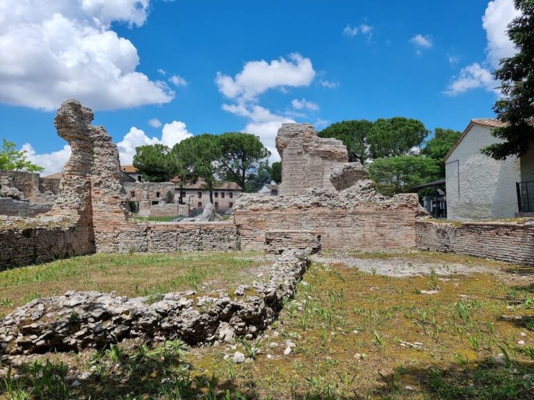
The archaeological site of Urbs Salvia encompasses approximately 40 hectares on a terraced hilltop plateau. The urban plan exhibits a grid layout with clear Hellenistic influences, adapted to the sloping terrain through a series of artificial terraces. Construction techniques include Roman concrete (opus caementicium) cores faced with brickwork (opus latericium) and panels of mixed opus reticulatum. The surviving structures predominantly reflect civic and religious functions, with monumental public buildings and fortifications well represented. Residential and economic buildings are less visible but indicated by surface remains and excavation data. The city’s expansion during the Augustan and Flavian periods is evident, followed by contraction and partial destruction in late antiquity. The fortification walls, while extensive, appear to have served primarily symbolic purposes.
Preserved remains include substantial sections of the city walls and gates, public entertainment venues, a temple complex, and water supply infrastructure. The site’s topography and construction methods demonstrate adaptation to local geography, with terraces supporting major buildings and streets. Many structures retain original Roman materials and techniques, although some have suffered damage from natural events and medieval reuse.
Key Buildings and Structures
City Walls and Gates
The city walls, constructed in the late 1st century BCE and early 1st century CE, extend approximately 2,500 meters and enclose an area of about 40 hectares. Built with Roman concrete cores and brick facing, the walls incorporate polygonal guard towers at regular intervals. The northern and large portions of the southern and eastern walls remain well preserved, while the western wall is largely lost. Two of the original four city gates survive: the Porta Nord (also known as Porta a Mesopirgo), located on the Via Salaria Gallica and characterized by a trapezoidal forecourt, and the Porta Gemina (Eastern Gate), featuring two arches (forici) and now incorporated into a 19th-century farmhouse. The walls functioned more as a civic boundary marker than as a military defense system.
Roman Theatre
Built in 23 CE during the Augustan period, the theatre follows a Hellenic architectural model and is among the largest in Italy. It is the only theatre in the Marche region preserving significant painted plaster remains. Constructed into the hillside with brick facing and a Roman concrete core, the cavea is divided into three tiers of seating arranged in six wedge-shaped sectors (cunei). Access was provided by an annular corridor that also supported hillside pressure and facilitated drainage. At the top of the cavea stood a small temple (sacellum). The stage area retains lower wall sections and foundations, including a semicircular exedra with the central porta regia (main actors’ entrance) and side Portae hospitales. Behind the stage lies an artificial terrace framed by a colonnade supported on a solid brick wall. A large portico (Porticus post scaenam) with a quadrangular plan was situated on a terrace behind the stage, supported on three sides by a massive retaining wall; recent excavations have revealed brick column bases now covered. The theatre suffered structural damage from ancient landslides. Excavations since the 18th century uncovered statues, including a head of Apollo and two headless figures, now housed in the State Archaeological Museum of Urbisaglia.
Sanctuary Complex of Salus Augusta (Temple and Cryptoporticus)
Located at the foot of the hill along the Via Salaria Gallica, the sanctuary dates to the early 1st century CE, likely under Tiberius. The main temple is a prostylos hexastyle structure with a six-columned façade and a partially preserved podium; original white limestone slabs are missing. The temple plan includes a pronaos and a cella with a semicircular rear wall, probably housing the cult statue of Salus Augusta, the goddess associated with imperial health and protection. Access was via two symmetrical lateral staircases leading to a platform, from which a central staircase ascended to the pronaos. Surrounding the temple is a porticus formed by four underground galleries (cryptoporticus), three divided into two aisles by central pillars, and a fourth serving as an access corridor. The cryptoporticus walls bear frescoes in the 3rd Pompeian style, arranged in three horizontal bands: a marble-like base with Gorgon masks, a central band depicting military trophies (helmets, shields, spears), and an upper band showing hunting scenes, exotic animals, and lunar masks. Adjacent to the main temple is a smaller temple and an area likely used for ritual water practices. Behind the sanctuary runs a via munita corresponding to the city’s first east cardo.
Amphitheatre of Urbs Salvia
Constructed shortly after 81 CE during the Flavian period, the amphitheatre lies outside the city walls in an extra-urban area. It features an elliptical arena measuring approximately 59 by 35 meters. The structure was built using Roman concrete with brick facing and alternating opus reticulatum mixtum panels. The external cavea wall includes semicircular niches that originally supported staircases to upper seating levels and possibly housed statues. The amphitheatre preserves the first tier of seats, the initial level of vomitoria (audience exit corridors), and bases of pillars for an external corridor. Two vaulted entrances on the major north-south axis served gladiators; the southern entrance is flanked by a narrow corridor identified as the Porta Libitinensis, dedicated to the goddess of death and used for removing fallen combatants. The arena floor retains water conduits for cleaning blood. Much of the brick facing was removed in the Middle Ages for construction of the medieval town and nearby abbey. The amphitheatre remains structurally substantial and is used for classical theatre performances during summer months.
Reservoir (Roman Aqueduct Cistern)
Located just outside the medieval city walls on Colle di San Biagio, the reservoir dates to the 1st century CE and formed part of the city’s water supply system. It consists of two barrel-vaulted underground tunnels connected at both ends, each approximately 51 meters long, 2.90 meters wide, and 4.10 meters high. Constructed in Roman concrete with brick lateral walls and internal hydraulic mortar coating, the reservoir had a capacity of about 1,000 cubic meters. Water was supplied by a 1.5-kilometer aqueduct with a gentle slope, bringing spring water from the opposite side of present-day Urbisaglia. Visible features include the water outlet with lead pipes, ventilation shafts for air exchange and maintenance, a water inlet with thick calcium carbonate deposits, and traces of wooden planks used in vault construction. The system operated by gravity due to the reservoir’s elevated position.
Edificio a Nicchioni (Building with Niches)
This 1st-century CE structure is situated between the theatre’s elevated terrace and the forum area. It functioned as a retaining wall with six large niches providing counterpressure to the earth behind. The building was concealed by a cryptoporticus, possibly comprising three galleries with two aisles each; two galleries remain visible, though frescoes are poorly preserved. The cryptoporticus embraced an adjacent terraced square facing east toward the forum. Roman remains from this area were later reused in nearby farmhouses, now serving as laboratories and storage for archaeological research. A 20th-century wood-fired oven typical of rural buildings is located near the niche wall.
Other Remains
Traces of Roman paved streets and porticoes have been identified in the forum area. Two building complexes south of the temple-cryptoporticus, named “Edificio delle Acque” and “Edificio del Pozzo,” were uncovered during recent excavations, though their functions remain partially unclear. Possible remains of a thermal building lie near the forum. Surface traces of brick walls and floor layers are scattered across various parts of the site, indicating additional domestic or civic structures. Outside the Porta Nord, two cremation tower tombs survive as internal cement cores; originally clad in white limestone slabs, they contained urns with ashes and bore commemorative inscriptions. These funerary monuments date to the Imperial period.
Archaeological Discoveries
Excavations have yielded numerous artifacts spanning from the city’s foundation in the late 2nd century BCE through late antiquity. Pottery includes locally produced tableware and imported amphorae, reflecting trade connections. Inscriptions found on funerary monuments, public buildings, and dedicatory altars provide information on civic status, imperial cult worship, and local elites. Coins from various emperors, especially Augustan, Tiberian, and Flavian periods, have been recovered, indicating economic activity and circulation. Tools related to agriculture and crafts have been found in domestic contexts. Domestic objects such as lamps and cooking vessels appear in residential areas. Religious artifacts include statuettes and ritual vessels associated with the sanctuary of Salus Augusta. Many finds derive from the temple complex, theatre, forum, and necropolis zones, contributing to understanding the city’s urban development and cultural practices.
Preservation and Current Status
The city walls and gates are generally well preserved, with some sections partially collapsed or lost, especially on the western side. The theatre retains substantial structural elements, though it suffered damage from ancient landslides. The amphitheatre preserves the first seating tier and key architectural features, despite medieval removal of brick facing. The sanctuary complex’s temple podium and cryptoporticus galleries survive, with frescoes in varying states of preservation. The reservoir remains largely intact underground, with visible hydraulic features. The Edificio a Nicchioni’s retaining wall and cryptoporticus galleries are fragmentary but identifiable. Other structures survive as foundations or surface traces. Conservation efforts focus on stabilizing exposed ruins, with some restoration interventions using modern materials. Vegetation and erosion pose ongoing challenges. Excavations and maintenance are conducted by the Archaeological Superintendency and the University of Macerata.
Unexcavated Areas
Several parts of the ancient city remain unexcavated or only partially studied, including residential quarters and economic districts beyond the main public buildings. Surface surveys and geophysical studies suggest buried remains beneath agricultural land and modern constructions. The area south of the temple-cryptoporticus complex and forum has been a focus of recent excavations, but other sectors await systematic investigation. Urban expansion of the medieval town and modern land use limit excavation possibilities in some zones. Future archaeological campaigns are planned but constrained by conservation policies and property ownership. No substantial evidence indicates post-Roman occupation of the original Roman site beyond the early Middle Ages.
Nearby sites