Sentinum: A Roman Municipium in Central Italy
Table of Contents


Visitor Information
Google Rating: 4.3
Popularity: Low
Google Maps: View on Google Maps
Official Website: www.sassoferratoturismo.it
Country: Italy
Civilization: Roman
Remains: Burial, City, Civic, Domestic, Economic, Entertainment, Infrastructure, Military, Religious, Sanitation

Context
Sentinum is situated near the contemporary town of Sassoferrato in the Marche region of central Italy. The archaeological site occupies a naturally defensible plateau within the Apennine mountain range, overlooking the Esino River valley. This elevated position provided strategic control over key routes linking the Adriatic coast to the interior of the Italian peninsula. The surrounding landscape is characterized by rolling hills and fertile valleys, which historically supported agricultural activities and influenced settlement patterns in the area.
Archaeological investigations have established that the region was initially inhabited by Umbrian populations during the Iron Age. However, the urban development of Sentinum itself is primarily a product of Roman colonization beginning in the 3rd century BCE. The site’s historical prominence is closely tied to the Battle of Sentinum in 295 BCE, a decisive engagement during the Third Samnite War. Roman occupation persisted through the Imperial period, after which the settlement experienced gradual decline. Excavations reveal a complex stratigraphy of urban structures, fortifications, and material culture, although the precise causes of abandonment remain incompletely documented.
Systematic archaeological work commenced in the 19th century and has continued intermittently, uncovering elements of the city’s fortifications, street network, and public and private buildings. Preservation of the remains varies, with some architectural features visible on the surface and others identified through geophysical surveys. Current conservation efforts, managed by regional heritage authorities, aim to safeguard the site and facilitate ongoing research, underscoring Sentinum’s significance for understanding Roman urbanism in central Italy.
History
Sentinum’s historical trajectory reflects its strategic location in central Italy and its integration into Roman military and administrative systems. Initially occupied by Umbrian groups during the Iron Age, the site later became a focal point in Rome’s expansionist campaigns. Its most notable historical moment is the Battle of Sentinum in 295 BCE, which decisively established Roman supremacy over a coalition of Italic peoples. Subsequently, Sentinum developed as a Roman municipium, undergoing phases of destruction and reconstruction linked to civil conflicts and imperial reforms. The city’s decline in late antiquity corresponds with regional instability and invasions, culminating in its abandonment and the emergence of medieval settlements nearby.
Iron Age and Pre-Roman Period
Archaeological evidence confirms the presence of Umbrian populations in the area surrounding Sentinum during the Iron Age. However, there is no indication of a significant pre-Roman urban settlement on the plateau itself. The early habitation likely consisted of dispersed rural communities exploiting the fertile valleys and natural defenses of the terrain. The urbanization associated with Sentinum appears to have commenced only after Roman expansion into the region, with no material remains attesting to a formal town prior to Roman foundation.
Roman Conquest and Republican Period (3rd century BCE – 1st century BCE)
During the 3rd century BCE, the Roman Republic incorporated Sentinum into its territorial domain, establishing it as a municipium within the Umbrian region. The city was founded on a previously uninhabited alluvial plateau at the confluence of the Sentino River and the Marena torrent, strategically positioned near the Via Flaminia and connected by secondary roads. Sentinum’s historical prominence is anchored by the Battle of Sentinum in 295 BCE, a pivotal conflict during the Third Samnite War. Roman forces defeated a coalition of Gauls (Senones), Etruscans, Umbrians, and Samnites, a victory recorded by ancient historians including Polybius and Livy. This battle was instrumental in consolidating Roman control over central Italy.
Archaeological data do not support the existence of a pre-Roman settlement at Sentinum, indicating that the city was a Roman foundation, possibly established following the Lex Flaminia of 232 BCE, which encouraged urban development along the Via Flaminia corridor. In the late Republic, during the civil wars around 41 BCE, Sentinum aligned with Mark Antony, hosting veteran settlers loyal to him. The city was captured and burned by Octavian’s forces under Quintus Salvidienus Rufus, an event corroborated by archaeological layers showing fire damage from this period. Subsequently, Sentinum was rebuilt and expanded under Augustus, entering a phase of urban growth and economic prosperity that endured for several centuries.
Imperial Roman Period (1st century BCE – 4th century CE)
Under the Roman Empire, Sentinum functioned as a municipium within the sixth Augustan region, Umbria. The city’s urban plan adhered to a strict orthogonal grid aligned with the cardinal points, featuring a principal north-south street (cardo maximus) and an east-west street (decumanus maximus). Defensive walls enclosed the city, with gates and paved streets constructed from white limestone basoli. Sidewalks and an advanced drainage system were integral components of the urban infrastructure.
Public amenities included urban thermal baths comprising rooms such as the calidarium (heated bath), frigidarium (cold bath), and a swimming pool. An additional thermal complex existed outside the city walls in the Santa Lucia area, serving travelers along nearby roads. This extra-urban facility featured a large courtyard with mosaic flooring and columns made from red Verona breccia stone, a material quarried in northern Italy.
Industrial activity is evidenced by remains of two bronze foundries and a probable glass furnace, indicating local artisanal production from the 1st century BCE through the 3rd century CE. Residential quarters, such as the “insula del pozzo,” reveal houses adorned with elaborate mosaics, including a notable depiction of the god Aion, now preserved in Munich. Inscriptions from the late 3rd century CE document the presence of municipal collegia and legal acts, reflecting organized civic administration. The last known epigraphic evidence from Sentinum dates to 343 CE, after which the city disappears from historical records.
Late Antiquity and Decline (4th – 6th centuries CE)
Following the mid-4th century CE, Sentinum underwent gradual abandonment. This decline coincided with broader regional challenges, including famine, plague, and increasing difficulty defending against invasions, particularly by the Lombards. The city’s population relocated to more defensible elevated sites, leading to the establishment of the medieval Castrum Saxum Ferratum around the year 1000 CE.
The decline of Sentinum may have been accelerated by the Gothic Wars and the incursions of Alaric I, which disrupted civic life and contributed to the collapse of urban structures. Archaeological evidence indicates a slow process of depopulation rather than sudden destruction, with many buildings falling into disuse and industrial activities ceasing.
Medieval Period and Rediscovery
During the early Middle Ages, the ruins of Sentinum were extensively quarried for building materials used in the construction of Sassoferrato and surrounding settlements. Interest in the site was revived during the Renaissance when humanist scholars such as Ciriaco d’Ancona and Flavio Biondo documented inscriptions and antiquities, preserving knowledge of its Roman heritage.
Archaeological investigations resumed in the late 19th century, notably following the construction of the Fabriano-Urbino railway line in 1890, which intersected the ancient city and led to significant discoveries. Excavations by Edoardo Brizio and Raniero Mengarelli mapped the city’s walls, streets, and building remains. Further finds in the 1920s included large mosaics now housed in the Civic Archaeological Museum of Sassoferrato.
Mid-20th century excavations expanded understanding of the urban layout, thermal baths, workshops, and the extra-urban Santa Lucia complex. Later research refined knowledge of the city’s plan and identified the forum area. Modern conservation efforts continue to protect the site and promote scholarly study, underscoring Sentinum’s importance for the study of Roman urbanism in the Marche region.
Daily Life and Importance by Period
Roman Conquest and Republican Period (3rd century BCE – 1st century BCE)
Following its establishment as a Roman municipium on previously undeveloped terrain, Sentinum’s population comprised Roman settlers alongside local Umbrian inhabitants integrated into Roman civic structures. The presence of veteran settlers loyal to Mark Antony around 41 BCE indicates a community with military affiliations and a social hierarchy including veterans, local elites, and common citizens. Gender roles likely conformed to Roman norms, with male citizens participating in public affairs and women managing domestic responsibilities.
The economy was primarily agrarian, supported by the fertile valleys surrounding the plateau, supplemented by artisanal crafts and small-scale trade facilitated by proximity to the Via Flaminia. The site’s location near river confluences and roads enabled the transport of goods such as grain, olives, and wine. Archaeological evidence of fire damage from the civil wars attests to disruptions in daily life and economic activity during this turbulent period.
Domestic architecture included insulae with courtyards and rooms for cooking and storage. Although direct evidence of interior decoration from this period is limited, regional parallels suggest the use of painted walls and simple mosaics. Clothing styles likely followed Roman fashions, with tunics and cloaks common among men and women. Religious practices probably combined Roman state cults with local Italic traditions, though specific temples or shrines from this early phase remain undocumented.
Sentinum’s role during the Republic was primarily strategic and military, serving as a municipium that consolidated Roman control in Umbria after the decisive Battle of Sentinum. Its position near major roads and rivers made it a local administrative center and a waypoint for military and commercial traffic, integrating the area into the expanding Roman network.
Imperial Roman Period (1st century BCE – 4th century CE)
During the Imperial period, Sentinum’s population stabilized and expanded, including Roman citizens, local Umbrians, artisans, and possibly freedmen and slaves. Epigraphic evidence attests to municipal officials such as duumviri and members of collegia, indicating organized civic governance. Family structures adhered to Roman patriarchal norms, with households centered around domus featuring both private and public spaces.
Economic activities diversified to include agriculture, artisanal production, and trade. Archaeological remains of two bronze foundries and a glass furnace demonstrate local industrial craftsmanship at a workshop scale. The city’s location along the Via Flaminia facilitated commerce in agricultural products such as grain, olives, and wine, as well as manufactured goods. Markets likely operated near the forum, recently identified through surveys, providing venues for the exchange of daily necessities and luxury items.
Dietary patterns, while indirectly evidenced, align with regional Roman norms, including staples such as bread, olives, fish, and wine. Clothing styles conformed to Roman fashions, utilizing wool and linen textiles. Domestic interiors were richly decorated, as exemplified by the “insula del pozzo,” where elaborate mosaics—including the renowned Aion mosaic—adorned floors, reflecting both aesthetic preferences and religious symbolism. Houses typically included courtyards, kitchens, storage rooms, and reception areas.
Public amenities such as urban thermal baths with calidarium and frigidarium rooms highlight the cultural importance of bathing for hygiene and social interaction. The extra-urban Santa Lucia thermal complex catered to travelers, indicating hospitality services linked to road traffic. Transportation relied on foot, animal-drawn carts, and river navigation where feasible.
Religious life incorporated Roman state cults alongside mystery religions, as evidenced by reused mithraic bas-reliefs. Civic festivals and collegia activities fostered social cohesion. Although no direct evidence of educational or cultural institutions survives, typical Roman municipal patterns would have included public readings and legal proceedings.
Sentinum functioned as a municipium within the sixth Augustan region (Umbria), with a formal urban plan featuring an orthogonal grid, defensive walls, and public infrastructure. Its role combined administrative governance, artisanal production, and services for travelers, maintaining regional significance through the early 4th century.
Late Antiquity and Decline (4th – 6th centuries CE)
After the mid-4th century CE, Sentinum’s population gradually diminished due to famine, plague, and increasing insecurity from Lombard invasions and the Gothic Wars. The social fabric fragmented as inhabitants relocated to more defensible elevated sites, culminating in the establishment of Castrum Saxum Ferratum. This demographic shift entailed a reduction in urban economic activities and a contraction of civic functions.
Archaeological evidence indicates a slow depopulation rather than abrupt destruction, with many buildings falling into disuse. Industrial workshops ceased operation, and public amenities such as baths were abandoned. Remaining residents likely engaged in subsistence agriculture and small-scale crafts, adapting to a more ruralized lifestyle.
Religious practices persisted but transformed, with Christianity becoming increasingly dominant. Although specific ecclesiastical structures at Sentinum are not documented, the broader region saw the rise of bishoprics and Christian communities. Social customs shifted toward localized, community-based organization rather than formal municipal governance.
Transportation and trade declined as security worsened, limiting access to long-distance routes. The city’s role within the empire effectively ended, replaced by emerging medieval centers. Sentinum’s decline reflects wider patterns of urban contraction and ruralization in late antique Italy.
Medieval Period and Rediscovery
In the early medieval period, Sentinum’s ruins served as a quarry for building materials, reflecting the absence of a resident urban population and the rise of nearby settlements such as Sassoferrato. The social and economic life of the area centered on feudal and agrarian structures rather than urban institutions.
Interest in the site revived during the Renaissance, when humanists documented inscriptions and artifacts, preserving knowledge of its Roman heritage. Archaeological excavations from the late 19th century onward uncovered the city’s layout, public buildings, and decorative art, illuminating daily life in earlier periods.
While no continuous medieval occupation of Sentinum itself is attested, the site’s legacy influenced regional identity and historical scholarship. The rediscovery and conservation of mosaics, inscriptions, and architectural remains have provided valuable insights into Roman urbanism and cultural practices in central Italy.
Overall, Sentinum’s transformation from a Roman municipium to a medieval ruin illustrates the profound social, economic, and political changes that reshaped the Italian landscape from antiquity through the Middle Ages.
Remains
Architectural Features
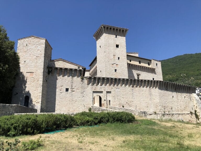
The ancient city of Sentinum was enclosed by defensive walls primarily constructed in the late Republican period, around the 1st century BCE. Surviving sections and foundations are visible, notably near the northwest corner where a probable defensive tower or bastion has been identified. The city’s layout follows a strict orthogonal grid aligned on a north-south axis, with the main thoroughfares—the cardo maximus running north-south and the decumanus maximus running east-west—paved with large white limestone basoli several decimeters thick. Sidewalks bordered these streets, and a substantial drainage system connected to the road network has been documented through excavation and geophysical survey.
Magnetometric prospections and archaeological excavations have helped define the city’s plan and locate the forum area, although the forum itself remains only partially excavated. The urban fabric includes secondary streets and insulae consistent with Roman municipal planning. Construction employed local stone and Roman building techniques, including stone masonry and brickwork. The remains indicate a primarily civic and residential urban center with integrated infrastructure.
Key Buildings and Structures
Urban Baths (Terme Urbane)
The urban thermal baths, situated in the Civita district within the city walls, date to the early 1st century CE. The complex comprises a calidarium (heated room), a frigidarium (cold bath), and a swimming pool. A large apsidal hall within the baths features a polychrome marble floor. Excavations conducted between 1954 and 1960, and again in 1974, revealed the baths’ architectural layout and associated streets and workshops. The baths were constructed using stone masonry and brick vaulting, with hypocaust heating systems evident in the calidarium.
Metalworking Workshop (Fonderia)
Located near the urban baths in the Civita area, two rooms have been identified as bronze statue foundries active from the 1st century BCE through the 3rd century CE. Archaeological remains include furnace structures, slag, and metalworking debris. The workshop is linked to the production of bronze statues and other metal objects. A fragment associated with the “Bronzi dorati da Cartoceto di Pergola” sculptural group was discovered here, indicating the workshop’s role in local artisanal production. The workshop’s walls and furnace bases survive in fragmentary condition.
Domus of the “Insula del Pozzo”
This residential complex, excavated in the Civita district, dates to the 2nd century CE. It is notable for a large mosaic depicting the god Aion, measuring approximately 5.34 by 4.94 meters, now housed in the Glyptothek in Munich. The domus includes multiple rooms and domestic features typical of Roman urban houses. Excavations uncovered mosaic floors, wall foundations, and household artifacts, indicating a well-appointed residence. The remains include stone and brick walls, with some evidence of decorative plaster.
Extra-Urban Baths (Terme Extraurbane) at Santa Lucia
Located just outside the city walls in the Santa Lucia area, this monumental thermal complex dates to the early Imperial period. The baths are arranged around a large courtyard decorated with mosaic flooring. The courtyard is surrounded by columns made of red Verona breccia, a stone quarried in northern Italy. Initially interpreted as a suburban villa, recent studies confirm its function as a thermal complex providing hospitality services to travelers. Excavations from the late 20th century onward clarified the layout of thermal rooms and reception areas. Structural remains include masonry walls, mosaic pavements, and column bases.
Roads and Infrastructure
Sentinum’s street network includes the main paved cardo maximus and decumanus maximus, constructed in the late Republican or early Imperial period. Streets are paved with thick white limestone slabs and bordered by sidewalks. The city’s drainage system, connected to the streets, includes channels and culverts designed to manage rainwater runoff. Excavations and the 1890 railway construction revealed sections of these roads and drainage features. The infrastructure reflects planned urban engineering consistent with Roman municipal standards.
Other Structures and Finds
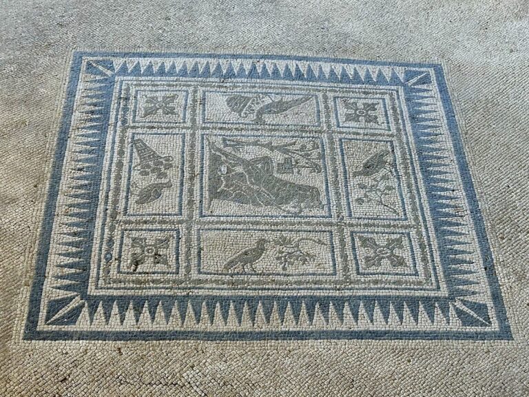
Foundations and remains of city gates and defensive structures survive in several locations, including a probable defensive building at the northwest corner of the walls. Numerous inscriptions from the late 3rd century CE have been recovered, including three tabulae patronatus documenting legal acts of municipal officials. Several mosaic pavements have been uncovered, such as a large marine monsters mosaic (14 by 9.8 meters) and a mosaic depicting the Rape of Europa, both conserved in the Civic Archaeological Museum of Sassoferrato. Mithraic bas-reliefs and inscriptions have been found reused in later contexts within the site.
Archaeological evidence also includes ceramic debris, glass fragments, slag, and ash layers associated with craft and economic activities. Surface traces and low walls of additional buildings have been identified but remain poorly documented. Possible cisterns and drainage features have been noted but not fully excavated. Traces of brick ovens and other craft-related installations have been found within the urban area, indicating diverse economic functions.
Archaeological Discoveries
Artifacts recovered at Sentinum span from the Iron Age through late antiquity, with the majority dating to the Roman Republican and Imperial periods. Pottery includes locally produced and imported amphorae and tableware, found in domestic and workshop contexts. Numerous inscriptions, including dedicatory and legal texts, provide evidence of municipal administration and religious practices. Coins from various Roman emperors have been found, reflecting economic activity and circulation.
Tools related to metalworking and domestic crafts have been uncovered, alongside domestic objects such as lamps and cooking vessels. Religious artifacts include Mithraic reliefs and altars, attesting to cultic activity. Many finds were made in the Civita district, workshops, baths, and residential quarters. The assemblage illustrates a range of economic production, trade connections, and daily life components within the city.
Preservation and Current Status
The preservation of Sentinum’s ruins varies across the site. City walls survive in fragmentary form, with some sections consolidated for protection. The urban baths retain substantial architectural elements, including mosaic floors and vaulted rooms, though some areas are partially collapsed. The metalworking workshop and residential domus remain visible primarily as foundations and floor mosaics. The extra-urban baths at Santa Lucia preserve mosaic pavements and column bases but lack complete superstructures.
Restoration efforts have stabilized several structures, particularly mosaics and wall sections, using original materials where possible. Some areas remain unexcavated or only partially cleared, with conservation focused on preventing further deterioration. Environmental factors such as vegetation growth and erosion pose ongoing challenges. Regional heritage authorities oversee excavation and conservation, with periodic research projects enhancing site documentation.
Unexcavated Areas
Several parts of Sentinum remain unexcavated or poorly studied. The forum area, while identified through magnetometric surveys, has not been fully excavated. Surface surveys indicate additional building remains and possible cisterns or drainage installations awaiting investigation. Some urban blocks and peripheral zones are covered by modern infrastructure or agricultural land, limiting excavation potential.
Future archaeological work is planned in coordination with conservation policies, though modern developments such as the Fabriano-Urbino railway line restrict access in some sectors. Geophysical prospections continue to inform research priorities, aiming to clarify the city’s full extent and urban organization without extensive intrusive excavation.
Nearby sites