Rotemberk Castle Ruins: A Medieval Fortress in Habřina, Czechia


Visitor Information
Google Rating: 3.9
Popularity: Very Low
Google Maps: View on Google Maps
Country: Czechia
Civilization: Unclassified
Remains: Military
History
Rotemberk is a medieval castle ruin located in Habřina, Czechia, originally built by local noble builders in the region during the late Middle Ages. Positioned strategically on a promontory overlooking the Hustířanka stream, the castle served as a center of local power and administration from the 14th to the 15th century.
The site likely emerged as a replacement for the nearby, older castle of Vražba following its destruction. While a solitary pottery fragment found on site hints at human activity in the 13th century, the first documented record of Rotemberk dates to around 1370–1371. At that time, the castle was held by Ješek of Neznášov. His family maintained possession for nearly a century, with the last known owner from this line noted in 1457 as Anna, the widow of Čeňko of Neznášov.
Afterward, ownership changed hands to Bavor of Hustířany in 1494, whose descendants controlled the estate. His son Jiřík and later Jiřík’s brother Jan the Elder inherited the property, but by the mid-16th century, specifically recorded in 1542, the castle had fallen into abandonment and was no longer in use.
In the 20th century, archaeological excavations carried out in 1978 uncovered evidence of the castle’s stone and brick construction along with ceramics typical of the 14th and 15th centuries. These findings confirmed the castle’s medieval heritage but did not allow for a full reconstruction of its original form. The ruins of Rotemberk, alongside the nearby remains of Vražba castle and the Habřina fortified settlement, have been officially protected as cultural monuments since 1964.
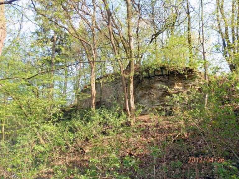
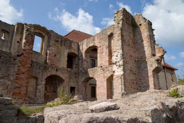
Remains
Rotemberk’s ruins sit atop a narrow promontory extending westward, naturally defended by steep slopes on most sides. The castle’s defensive system included an irregularly shaped double earthen rampart, with especially strong fortifications on the eastern side where a neighboring plateau opens, ensuring control over the most vulnerable approach.
The castle was composed of a two-part complex. The main fortified core was separated from an elongated outer bailey to the east by a neck ditch—a defensive trench cutting through the narrow land connecting the castle to the surroundings. Remains of stone and brick fortifications survive principally along the southern and eastern sections of the site.
A round tower once stood prominently in the core’s center, likely serving as a key defensive structure and lookout. On the southern edge of the castle, a discernible depression marks the former location of a vaulted cellar, indicating an underground storage or utility space. Meanwhile, a well was situated in the southeastern corner of the main enclosure, supplying water to the inhabitants.
The castle is classified as a “closed castle,” meaning the outer walls formed a continuous enclosure around the core buildings. Over time, the upper parts of these walls have collapsed inward, leaving a mound of rubble that rises above the original medieval ground level. This layering preserves a record of the castle’s former layout despite the ruinous state.
Among the archaeological finds are medieval pottery fragments dating from the 14th and 15th centuries, which help to confirm the site’s period of use. The surrounding landscape has been altered by agricultural activities in more recent centuries, which has affected the preservation of some features. At the base of the castle hill, the Podhradní mill was first documented in 1542; this building, originally connected with the castle’s estate, has since been converted into a residential house.
Nearby sites