Ocriculum Archaeological Park: A Roman Municipium and Early Christian Center in Umbria, Italy
Table of Contents


Visitor Information
Google Rating: 4.5
Popularity: Low
Official Website: www.otricoliturismo.it
Country: Italy
Civilization: Byzantine, Roman
Site type: Burial, City, Civic, Domestic, Economic, Entertainment, Infrastructure, Military, Religious, Sanitation

Context
The Ocriculum Archaeological Park is situated near the contemporary town of Otricoli in central Italy’s Umbria region. Positioned on a plateau overlooking the Tiber River valley, the site commands a strategic view of the surrounding landscape. It lies along the ancient Via Flaminia, a principal Roman road connecting Rome to the Adriatic coast, approximately 69 kilometers north of Rome. This location established Ocriculum as a critical node within regional communication and transportation networks throughout antiquity.
Archaeological evidence attests to continuous occupation from the Iron Age through the Roman Imperial period. The settlement expanded notably during the Roman Republic and early Empire, with urban development primarily dating from the 2nd century BCE to the 4th century CE. Epigraphic sources confirm its status as a municipium integrated into Roman administrative frameworks. The site’s decline is archaeologically visible through diminished construction activity and phases of abandonment in late antiquity, although direct historical accounts explaining this process are lacking.
Excavations initiated in the 18th century and continuing intermittently into the present have revealed substantial remains of public and private architecture, including mosaics and inscriptions. Conservation efforts prioritize the stabilization of exposed ruins and facilitating scholarly and public engagement. Research at Ocriculum has enhanced understanding of Roman urban planning and the site’s role within the broader network of Roman roads, while ongoing studies seek to clarify its later occupation and decline.
History
Ocriculum’s historical trajectory reflects its transformation from an indigenous Umbrian settlement into a Roman municipium and subsequently an early Christian episcopal center. Its commanding position overlooking the Tiber valley and location on the Via Flaminia established it as a significant point of control and communication in central Italy. Over time, Ocriculum experienced phases of urban growth, integration into Roman provincial structures, military conflict, and eventual contraction during the early medieval period. Archaeological and literary sources together provide a detailed picture of its evolving political, military, and religious roles within Umbria and the Roman Empire.
Umbrian Period and Roman Alliance (Pre-3rd century BCE to early 3rd century BCE)
Initially, Ocriculum was an Umbrian settlement, likely situated on the hill beneath present-day Otricoli. The toponym derives from the Umbrian root “OKRI-,” meaning “sacred,” indicating the site’s religious significance within local Italic traditions. Following the defeat of Umbrian tribes at the Battle of Mevania during the Samnite Wars, Ocriculum entered into a formal alliance with Rome in 308 BCE, becoming a foederatus, or “friend of Rome,” as recorded by Livy. This alliance marked the beginning of Ocriculum’s role as a frontier community at the intersection of Umbria, the Ager Faliscus, and Sabina.
The construction of the Via Flaminia in 220 BCE, which traversed the area, further enhanced Ocriculum’s strategic importance by linking it to major Roman communication and trade routes. This infrastructure development facilitated the settlement’s integration into broader economic and military networks, setting the stage for its urban expansion in subsequent centuries.
Roman Republican and Early Imperial Period (3rd century BCE – 1st century CE)
During the late Republic and early Empire, Ocriculum underwent significant urban reorganization. A new, unwalled settlement was established approximately two kilometers south of the original hilltop site, situated closer to the Tiber River’s bend and the Via Flaminia. This relocation optimized access to riverine and overland trade routes, fostering economic growth. Epigraphic evidence confirms that Ocriculum attained municipium status, governed by a quattuorviri magistracy and assigned to the Arnensis tribe, reflecting full incorporation into Roman civic administration.
The local economy was diverse, with olive cultivation and oil production playing prominent roles, as indicated by the river port known as the “Porto dell’Olio.” Inscriptions referencing a “pensor lignarius” attest to organized timber trade, likely including firewood. The city also developed a notable pottery industry, producing relief-decorated “Popilius Cups” and stamped bricks and tiles distributed along the Tiber to Rome. The presence of elite Roman figures, such as Titus Annius Milo—an influential mid-1st century BCE politician and associate of Cicero—and Pompea Celerina, mother-in-law to Pliny the Younger, who owned estates in Ocriculum, underscores its appeal as a rural retreat for the aristocracy.
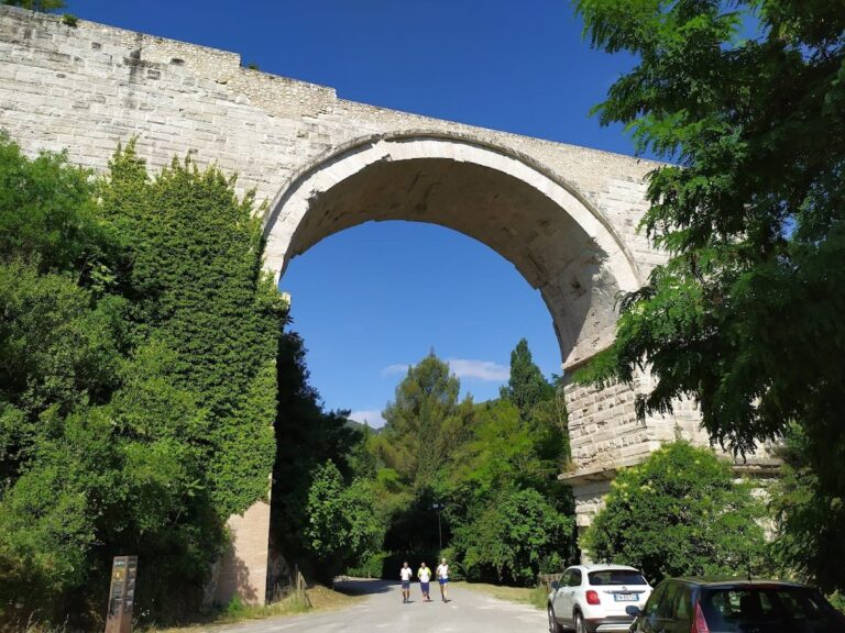
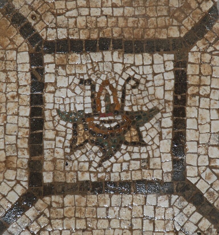
Architecturally, Ocriculum featured monumental public buildings including baths with an octagonal mosaic room, a theatre integrated into the natural hillside with vaulted substructures and an elaborately decorated stage front, and the “Great Substructures,” a large complex of twelve vaulted rooms on two levels. This latter structure likely supported a temple precinct or functioned as warehouses associated with the nearby river port. A monumental nymphaeum approximately 50 meters in length, constructed in opus reticulatum with alternating semicircular and rectangular niches housing fountains, was supplied by the San Vittore river through an advanced hydraulic system. The forum contained a basilica adorned with numerous imperial statues, suggesting its use as an Augusteum or center for the imperial cult. Several monumental tombs, including a distinctive drum-shaped tomb belonging to Lucius Cominus Tuscus of the Arnensis tribe, stood prominently near the Via Flaminia, which itself retains well-preserved basalt paving stones and visible cart wheel ruts.
Late Roman and Early Christian Period (4th–6th centuries CE)
Following the administrative reforms of Emperor Diocletian, Ocriculum was incorporated into the Tuscia et Umbria region. The city is documented as a stopping point for Emperor Constantius II during his journey to Rome in the 4th century CE. In the winter of 412–413 CE, the territory near Ocriculum was the site of a significant battle between the usurper Heraclianus, who arrived from Carthage with a large fleet, and forces loyal to Emperor Honorius under the command of the comes Marino. Contemporary historian Hydatius reports that Honorius’s forces secured a decisive victory with approximately 50,000 casualties inflicted on Heraclianus’s army.
Christianity had become firmly established in Ocriculum by this period, as evidenced by four known bishops—Erculio, Costanzo, Fulgentius, and Dominic—who participated in ecclesiastical councils from the late 5th to early 7th centuries. Bishop Fulgentius is credited with erecting an altar dedicated to Saint Vittore, reflecting the city’s religious transformation. The Christian community’s growth coincided with the adaptation of civic spaces for ecclesiastical use.
Between the late 6th and early 7th centuries, Ocriculum suffered destruction during the Lombard invasions, leading to the abandonment of the lower city near the river. The population retreated to the original hilltop settlement, marking a significant contraction of urban occupation and the decline of the riverine center.
Medieval and Later Periods
Following the Lombard destruction, Ocriculum’s prominence diminished considerably. The lower city remained largely deserted, while the hilltop site persisted as a smaller, rural settlement with limited archaeological evidence of continued occupation. The site’s strategic and administrative importance waned as regional power centers shifted during the early medieval period. No substantial Byzantine architectural remains have been identified, though minor structural modifications suggest some continued, albeit limited, use.
Archaeological Investigations and Preservation (18th century to present)
Systematic archaeological excavations commenced in the late 18th century, revealing major public structures including the baths, theatre, basilica, amphitheatre, and sections of the Via Flaminia. Noteworthy discoveries include the octagonal mosaic room from the baths, now housed in the Vatican Museums, and sculptural fragments from the theatre’s stage front. The “Great Substructures” and monumental nymphaeum exemplify the city’s architectural complexity and hydraulic engineering.
The Via Flaminia segment at Ocriculum remains well preserved, featuring large leucite paving stones and visible wheel ruts. Several monumental tombs survive, including a tower tomb with a dovecote and a drum-shaped tomb faced with travertine. The archaeological park currently encompasses approximately 36 hectares, incorporating the forum, public buildings, necropolis, and road infrastructure. Ongoing conservation and research efforts continue to elucidate Ocriculum’s urban development, its integration into Roman road networks, and the processes underlying its decline. The site’s stratified occupation offers valuable insights into the transformation from an Umbrian settlement to a Roman municipium and early Christian center.
Daily Life and Importance by Period
Umbrian Period and Roman Alliance (Pre-3rd century BCE to early 3rd century BCE)
During its Umbrian phase, Ocriculum was a community embedded in indigenous Italic cultural traditions, likely situated on the hill beneath modern Otricoli. The population spoke Umbrian and organized socially around clan-based family groups. The settlement’s name, derived from the root “OKRI-” meaning “sacred,” suggests a religious focus on local deities and territorial landmarks. Gender roles and family structures conformed to typical Italic patriarchal patterns, with communal religious observances integral to social life.
Economically, inhabitants practiced subsistence agriculture, cultivating cereals, legumes, and olives, supplemented by hunting and animal husbandry. Craft production was small-scale, and no evidence indicates large industrial activity. The settlement’s location at the crossroads of Umbria, Ager Faliscus, and Sabina positioned it as a frontier community with a mixed cultural identity. Daily life centered on farming and local religious rites, with simple dwellings likely constructed of stone foundations and thatched roofs, consistent with comparable Umbrian sites. The alliance with Rome in 308 BCE initiated integration into wider political and economic networks, foreshadowing urban development.
Roman Republican and Early Imperial Period (3rd century BCE – 1st century CE)
Following the establishment of the Via Flaminia and relocation closer to the Tiber River, Ocriculum evolved into a Roman municipium with a heterogeneous population comprising Roman settlers, indigenous Umbrians, and freedmen. Inscriptions attest to governance by quattuorviri magistrates and affiliation with the Arnensis tribe, confirming full integration into Roman civic structures. The social hierarchy included wealthy landowners, artisans, merchants, and slaves. Elite families, such as those of Titus Annius Milo and Pompea Celerina, maintained rural villas, reflecting the city’s role as a retreat for the aristocracy.
The economy was multifaceted. Olive cultivation and oil production were prominent, as evidenced by the “Porto dell’Olio” and remains of olive presses. Timber trade flourished, with inscriptions referencing officials like the “pensor lignarius.” Pottery workshops produced distinctive relief-decorated “Popilius Cups” and stamped bricks and tiles, indicating organized artisanal production. Riverine and road transport facilitated commerce, linking Ocriculum to Rome and other markets.
Diet consisted of bread, olives, wine, fish from the Tiber, and locally grown fruits and vegetables. Clothing followed Roman styles, including tunics, cloaks, and sandals. Domestic interiors featured mosaic floors, such as the octagonal mosaic in the baths, and painted walls, indicating wealth and aesthetic refinement. Houses were arranged around courtyards with kitchens and storage rooms, supporting family-centered households.
Public life centered on the forum, basilica, baths, and theatre, venues for civic, religious, and entertainment activities. The basilica’s imperial statues suggest participation in the imperial cult, while monumental tombs along the Via Flaminia reflected social status and family prestige. Religious practices combined traditional Roman deities with local cults, and public festivals marked the civic calendar. Transportation relied on carts along the paved Via Flaminia and boats on the Tiber, facilitating movement of goods and people.
Late Roman and Early Christian Period (4th–6th centuries CE)
In late antiquity, Ocriculum retained municipium status within the Tuscia et Umbria region but underwent significant social and political changes. The population included Romanized locals and Christian communities, with bishops such as Erculio, Costanzo, Fulgentius, and Dominic documented in ecclesiastical councils. Christianization introduced new religious practices centered on church worship and veneration of saints, exemplified by Bishop Fulgentius’s altar to Saint Vittore.
Economic activities persisted but likely contracted, focusing on sustaining local needs amid imperial instability. Olive oil production, timber trade, and pottery manufacture may have continued at reduced scale. The monumental nymphaeum and hydraulic infrastructure suggest ongoing maintenance of public amenities. Diet and clothing remained consistent with Roman traditions, though Christian modesty may have influenced social customs.
Civic life increasingly intertwined with ecclesiastical authority, as bishops assumed leadership roles alongside or replacing traditional magistrates. The forum and basilica likely adapted to Christian functions. The battle near Ocriculum in 412–413 CE and subsequent Lombard invasions disrupted urban continuity, leading to population decline and abandonment of the lower city.
Transportation remained centered on the Via Flaminia and the Tiber, though insecurity may have limited trade. Educational activities probably included Christian catechesis and liturgical instruction, reflecting the Church’s growing influence. Socially, the community reorganized around the hilltop settlement, emphasizing defensive concerns and religious identity.
Medieval and Later Periods
After the Lombard destruction, Ocriculum’s urban fabric contracted significantly, with the population retreating to the original hilltop site. Daily life shifted from an urbanized municipium to a smaller rural settlement with limited economic activity. Agriculture dominated subsistence, with reduced craft production and trade.
The demographic composition became more localized, with diminished social stratification and absence of large elite estates. Christian religious structures persisted, but no major Byzantine architectural developments are evident. Community organization centered on ecclesiastical leadership and small-scale agrarian households. Transportation and commerce were minimal compared to earlier periods, reflecting the site’s diminished strategic importance. Cultural life focused on religious observance and local traditions, with limited evidence of formal education or public entertainment.
Archaeological Discoveries and Site Description (18th century to present)
Although pertaining to modern investigation, archaeological research has illuminated Ocriculum’s material culture and urban organization across its history. Excavations have revealed domestic mosaics, public baths, theatres, and monumental tombs, providing insights into inhabitants’ lifestyles, social hierarchies, and economic activities. The preservation of the Via Flaminia segment with wheel ruts illustrates the importance of transportation infrastructure in daily commerce and communication. Conservation efforts continue to enhance understanding of how successive populations adapted the site’s landscape and architecture to their needs.
Remains
Architectural Features
The archaeological remains at Ocriculum predominantly date from the late Republican through early Imperial periods, approximately the 1st century BCE to the 4th century CE. The urban layout reflects a combination of civic, religious, and economic functions, with buildings primarily constructed in opus reticulatum (a net-like pattern of small tuff blocks) and opus caementicium (Roman concrete). The city expanded from its original hilltop location to a lower plateau adjacent to the Tiber River, where most monumental architecture is concentrated. The site includes public entertainment venues, religious precincts, and infrastructure associated with the Via Flaminia and a river port. Over time, especially after late antiquity, the city contracted, with abandonment of the lower city and population retreat to the hilltop. Surviving remains range from well-preserved masonry to fragmentary foundations and funerary monuments.
Key Buildings and Structures
Baths Complex
The baths complex dates to the 2nd century CE and occupies an artificially leveled valley area near the Tiber. It includes a large octagonal room renowned for its polychrome mosaic pavement, fragments of which are preserved in the Museo Pio-Clementino of the Vatican Museums. To the north, evidence of winter baths is attested by inscriptions documenting 4th-century restorations and surviving statue bases. The complex was supplied by hydraulic works channeling water from the Rio San Vittore through an underground canal. Structural remains of bathing rooms and service areas are visible on site, with the octagonal mosaic floor partially intact.
Theatre
Constructed in the 1st century CE, the Roman theatre is primarily built in opus reticulatum and exploits the natural slope for its cavea (seating area). The cavea is supported at its lateral ends by three vaulted substructures on each side. Behind the seating rows lie two partially visible ambulatories (walkways). Only a sector of the upper gallery survives, covered by a barrel vault. The external perimeter consists of a retaining wall reinforced with pillars. The scaenae frons (stage front) was richly decorated with colored marbles and statues, including large figures of the Muses, now housed in the Vatican Museums. The theatre’s remains include seating tiers and stage foundations.
Great Substructures (Grande Sostruzione)
This monumental complex dates from the late 1st century BCE to early 1st century CE and comprises twelve vaulted rooms arranged on two levels, extending approximately 80 meters in length. The upper rooms feature opus reticulatum walls, some retaining original plaster. The structure likely served as a monumental terrace supporting a large podium, possibly for a temple precinct or as warehouses related to the nearby river port known as Porto dell’Olio. A smaller adjacent substructure expanded the central city area with an additional terrace. The vaulted rooms and robust construction indicate significant architectural investment.
Nymphaeum
The monumental nymphaeum, dating from the late 1st century BCE to early 1st century CE, measures about 50 meters in length. Built in opus reticulatum, its façade features alternating semicircular and rectangular niches housing three fountains. The nymphaeum is connected by tunnels to a cistern within the Antiquarium Casale San Fulgenz and was supplied by the San Vittore river’s waters. It formed part of a series of buildings creating a monumental façade on the valley slope, demonstrating advanced hydraulic engineering.
Forum and Basilica
The forum lies north of the San Vittore river and was excavated in the late 18th century. It includes a large basilica building constructed in the 1st century CE, which contained numerous imperial statues. The basilica’s layout comprises a central nave and side aisles, consistent with public buildings used for administrative or cultic functions. The presence of imperial statuary suggests its use as an Augusteum or center for the imperial cult. Structural remains include foundations, wall fragments, and paved surfaces.
Amphitheatre
Dating to the 1st century CE, the amphitheatre’s external structure has mostly disappeared. However, sections of the cavea’s intermediate gallery remain, along with the two main entrances. The ancient arena floor and part of the podium have been uncovered. The amphitheatre is partially cut into a rock bank, which forms half of the seating area. The surviving masonry includes vaults and seating supports, indicating a modest-sized venue for public spectacles.
Via Flaminia
The Via Flaminia passes through the site and is preserved in several sections. The road is paved with large basalt stones and displays clear wheel ruts from ancient carts. It runs parallel to the modern state road and enters the ancient city through a monumental gate marked by a tall rectangular pilone (pillar) built in opus reticulatum. The road is flanked by several monumental tombs, including a large drum-shaped tomb belonging to Lucius Cominus Tuscus of the Arnensis tribe. The Via Flaminia’s remains include paving, curbstones, and associated funerary monuments.
Monumental Tombs
Several monumental tombs stand unusually within the city valley near the Via Flaminia. The drum-shaped tomb has a square base, constructed in opus caementicium (Roman concrete) and faced with travertine. It is located adjacent to a public well with seating. Another funerary monument is tower-shaped, with a square plan surmounted by a circular body and a dovecote at the top, a form common in the Eastern Mediterranean designed for visibility. A niche tomb built in opus caementicium with large tuff slabs and mortar, covered with brickwork, dates to the imperial period. These tombs exhibit diverse funerary architecture within the urban area.
Monumental Entrance Pillar (Pilone)
A tall rectangular pillar constructed in opus reticulatum marks the monumental entrance to the urban area near the nymphaeum and public buildings. The pilone stands as a freestanding architectural element, likely serving as a city gate marker or boundary monument. Its masonry and dimensions are consistent with late Republican or early Imperial construction.
Other Remains
Several farmhouses on the site incorporate Roman architectural elements, including opus reticulatum walls with arches, opus spicatum (herringbone) floors, and large Roman cisterns integrated into their structure. Sunken trackways cross the site, revealing traces of arcaded buildings, wells, and walls. A public fountain divided internally by two stone balustrades shows marks from bucket ropes used for water drawing. These features indicate domestic and infrastructural components within the urban fabric. Additionally, surface remains include fragments of walls, paving, and small-scale structures related to economic activities such as pottery production and olive oil trade.
Archaeological Discoveries
Excavations at Ocriculum have uncovered a variety of artifacts spanning from the Iron Age through the late antique period. Pottery finds include locally produced wares such as Popilius Cups and tiles, as well as amphorae linked to olive oil trade. Inscriptions document municipal governance by quattuorviri and the city’s ascription to the Arnensis tribe, providing administrative context. Coins from various imperial reigns have been recovered, reflecting economic activity and circulation. Tools related to agriculture and craft production have been found in domestic and workshop areas. Domestic objects such as lamps and cooking vessels appear in residential contexts. Religious artifacts include statuettes and altars, notably an altar dedicated to Saint Vittore erected by Bishop Fulgentius. These finds collectively illustrate the site’s economic, administrative, and religious dimensions.
Preservation and Current Status
The ruins at Ocriculum exhibit varying states of preservation. The baths’ octagonal mosaic room remains partially intact, with visible pavement and structural elements. The theatre retains substantial masonry, including vaulted substructures and stage foundations, though upper galleries are fragmentary. The Great Substructures survive as a series of vaulted rooms with some plastered walls. The nymphaeum’s façade and fountains are preserved, along with its hydraulic connections. The forum basilica’s foundations and wall fragments remain, while the amphitheatre is largely reduced to cavea sections and entrances. The Via Flaminia’s basalt paving and monumental gate pillar are well preserved. Tombs show varying degrees of conservation, with some travertine facing intact. Conservation efforts have stabilized exposed ruins, with some areas restored using modern materials. Vegetation and erosion pose ongoing challenges. Excavations and maintenance are conducted by the Soprintendenza per l’Umbria, focusing on structural stabilization and public accessibility.
Unexcavated Areas
Significant portions of the ancient city remain unexcavated, particularly in the lower valley and peripheral zones. Surface surveys and geophysical studies suggest buried remains of residential quarters, workshops, and additional funerary monuments. The original hilltop settlement area has limited archaeological investigation. Modern agricultural use and infrastructure limit excavation scope in some sectors. Future research is planned but constrained by conservation policies and land ownership. No extensive Byzantine or medieval architectural remains have been identified, though minor modifications are suspected in some areas. The full extent of the river port and associated economic installations awaits further exploration.
Nearby sites