Krak des Chevaliers: A Crusader Castle in Syria


Visitor Information
Google Rating: 4.6
Popularity: Low
Google Maps: View on Google Maps
Country: Syria
Civilization: Crusader, Medieval Islamic, Ottoman
Remains: Military
History
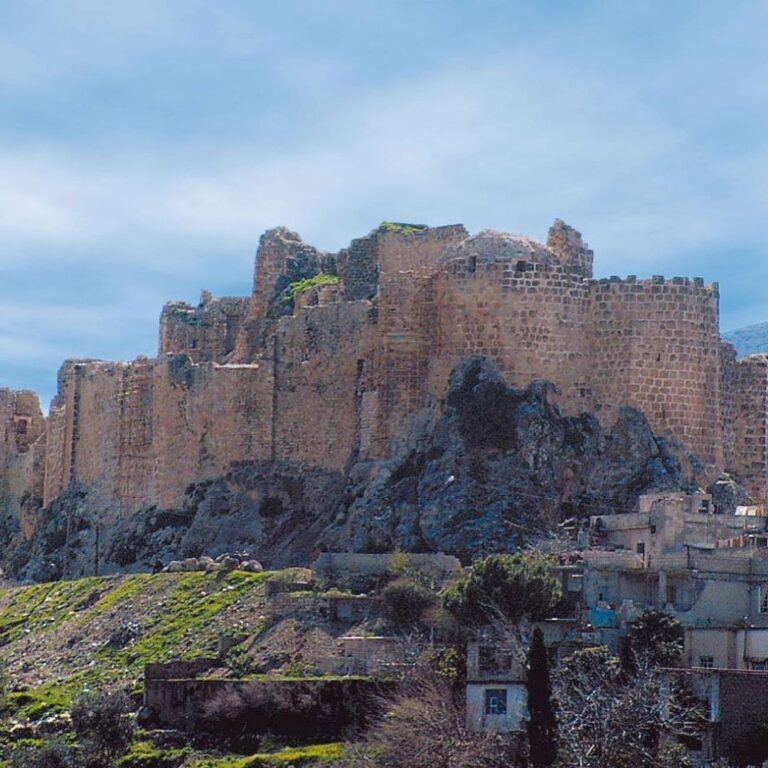
Krak des Chevaliers is located in the municipality of al-Husn in modern-day Syria. Originally established by the Mirdasid emir Shibl al-Dawla Nasr in 1031, the site began as a small fortress manned by Kurdish tribal forces. It was initially called Hisn al-Safh and later became known as Hisn al-Akrad, meaning “Fortress of the Kurds,” reflecting the Kurdish presence stationed there. The fortress was built on a prominent hill about 650 meters high, strategically positioned to oversee the Homs Gap, a vital corridor linking the Syrian interior with the Mediterranean coast near Tripoli.
During the First Crusade, Crusader forces led by Raymond IV of Toulouse seized the fortress in January 1099. However, this initial occupation was short-lived as Crusaders moved toward Jerusalem. It was not until 1110 that permanent control was established when Tancred, Prince of Galilee, took possession. By 1142, Raymond II, Count of Tripoli, granted the castle and its lands to the Knights Hospitaller. The Hospitallers transformed the site into their main military base in Syria and began extensive building and strengthening programs, lasting until around 1170.
Throughout the 12th and 13th centuries, Krak des Chevaliers played a key role as both a military stronghold and a center of administration for the Hospitallers. The castle governed a wide area and collected tribute from nearby Muslim communities. It housed up to 2,000 knights at its peak. Despite repeated attacks, the fortress endured sieges by Nur ad-Din in 1163 and by the great Muslim leader Saladin in 1188, both of which failed to take the castle. In 1271, the Mamluk Sultan Baibars successfully captured Krak des Chevaliers after a 36-day siege. Reports suggest this victory was facilitated by a forged order allegedly issued by the Hospitaller Grand Master, instructing surrender.
Following the conquest, Baibars repaired the castle and made significant changes including converting the Hospitaller chapel into a mosque adorned with mihrabs, which are niches indicating the direction of Mecca for prayer. The fortress then served as a military base under Mamluk rule. With the arrival of the Ottoman Empire in 1516, Krak des Chevaliers gradually lost its military importance. By the 19th century, the castle’s ruins were inhabited by a village of approximately 500 residents, whose presence caused damage to the historic structure.
French authorities assumed control of the site in 1933, removing the village population and undertaking restoration and cleaning. After Syria gained independence in 1946, the castle remained under Syrian custody. Recognized for its cultural and historical value, Krak des Chevaliers was designated a UNESCO World Heritage Site in 2006, along with nearby Qal’at Salah El-Din. The castle sustained damage during the Syrian civil war beginning in 2011, including shelling and airstrikes between 2012 and 2013, but was retaken by government forces in 2014. Subsequent restoration efforts have aimed to preserve the site.
Remains
Krak des Chevaliers is an expansive medieval spur castle constructed primarily from carefully cut limestone blocks joined with minimal visible mortar. It represents one of the most refined examples of a concentric fortress, characterized by two main layers of defensive walls arranged to provide multiple lines of defense.
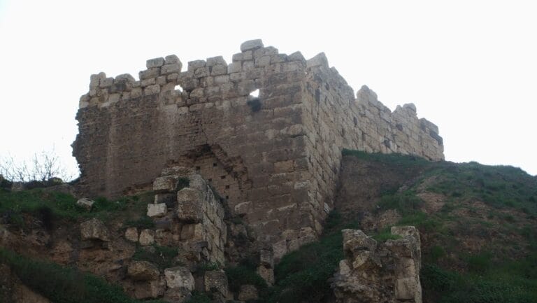
The outer ward dates mainly from the early 13th century and is enclosed by a curtain wall approximately nine meters tall and three meters thick. This wall is punctuated by seven large round towers, each measuring between eight and ten meters across, which project outward to allow defenders better angles for attack and protection. These round towers replaced earlier square ones found in the inner ward. The outer defenses feature elaborate stone openings called machicolations, through which defenders could drop projectiles or boiling substances on attackers below. Arrow slits cleverly cover blind spots, reducing areas where attackers could shelter unseen.
Entry into the castle was carefully controlled through a fortified passage stretching about 137 meters. Its path follows a zigzag pattern designed to expose invaders to crossfire and includes murder holes—openings above the gate—where defenders could attack from above. This complex entrance slowed and weakened any assault.
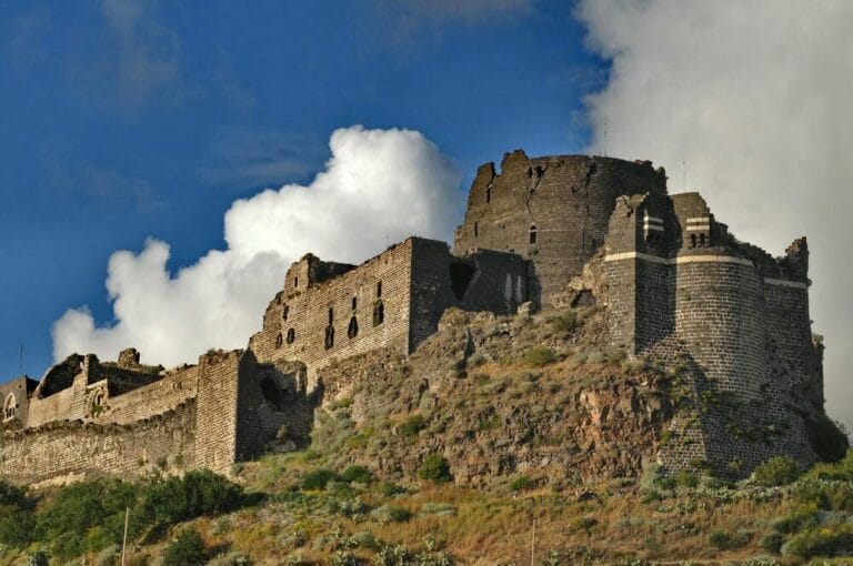
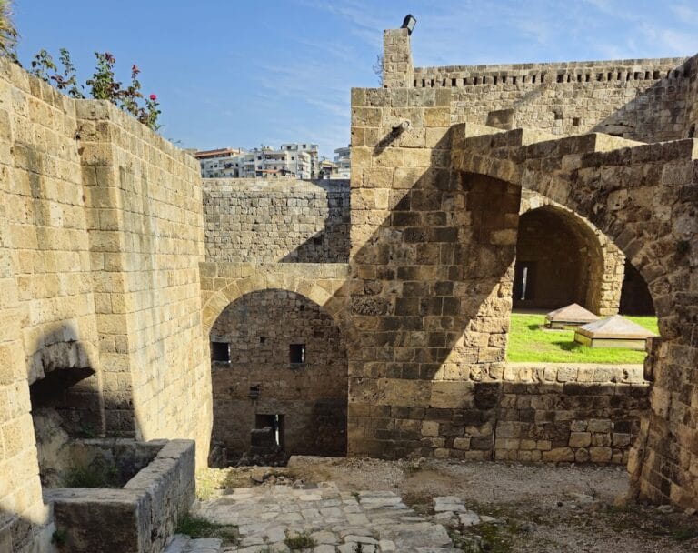
The inner ward, constructed between 1142 and 1170, is set on steep slopes which naturally protect most sides of the castle except the south. Its curtain wall is reinforced by square towers and encloses vaulted chambers and a central courtyard. This area was home to about 60 knights during the castle’s height, including quarters for the Grand Master in the southwestern tower. A cistern supplied with water from an aqueduct ensured the garrison had a reliable water source, while a surrounding moat-like ditch added further defenses.
Inside the castle stands a Romanesque-style chapel rebuilt following an earthquake around 1170. This barrel-vaulted building, measuring roughly 21.5 meters long and 8.5 meters wide, is oriented east-west and terminates in an apse. Fragments of Crusader-era frescoes discovered within depict religious scenes such as the Presentation of Jesus at the Temple. Although these paintings have suffered deterioration due to mold, smoke, and moisture, they remain significant relics of the castle’s original decoration.
Additional architectural highlights include a large hall featuring Gothic design elements from the 1230s and a long arcade room approximately 120 meters in length. This room served mixed purposes, such as lodging, storage, and possibly meetings. Latrines were ingeniously integrated into the outer wall, highlighting practical medieval design.
Beyond the main walls, a fortified suburb or burgus existed outside the gates, providing space for support functions. During the 1271 siege, defenders employed a triangular outwork or palisade as part of their defensive strategy. The castle’s water reservoir was notably large, capable of sustaining a siege for years by holding ample supplies.
Following its conquest, the Mamluks made key modifications: they converted the chapel into a mosque, installing mihrabs to indicate the direction of prayer, and added a southern bastion with a square tower featuring vaulted ceilings supported by a central pillar. The castle’s overall design—combining steep slopes, bent entrance paths, murder holes, machicolations, and wall-walks called chemin de ronde—reflects a highly advanced military architecture tailored to withstand prolonged assaults.