Margat: A Crusader Fortress and Hospitaller Stronghold in Syria


Site at a Glance
- Rating
- 4.6
- Popularity
- Low
- Country
- Syria
- Primary era
- Medieval
- Eras represented
- Medieval
- Civilizations
- Crusader, Knights Hospitaller, Principality of Antioch
- Site type
- Military
- Remains
- Castle
On this page16 sections
History
Margat, also known as al-Marqab, is a former Crusader fortress in Syria near Banias, developed from an earlier Muslim stronghold on the western slopes of the Ansariyah Mountains. The medieval fortress occupied a strategic position above the coastal route between Tripoli and Latakia, linking the Principality of Antioch with the County of Tripoli. Its Arabic name, meaning “the Watch Post,” reflects its command over a long stretch of coast.
Early Fortress and Crusader Rule
A prosperous settlement stood below the castle hill during the Roman period. Local Muslim tribes built the first fortress on the northern part of the summit in 1062. After the Battle of Harran in 1104, a major defeat of Crusader forces by the Seljuk Turks, Margat came under Byzantine control. A few years later, Tankred, Prince of Galilee and regent of Antioch, captured it and incorporated it into the Principality of Antioch. After Tankred’s death, the fortress passed to Roger, Prince of Antioch, who gave it the name Margat.
During the twelfth century, the Mazoir family held Margat as a fief. Renaud de Mazoir received it in 1117, and the family retained it for three generations. Its members developed the summit, creating a residence and quarters for their household. Muslim forces briefly seized Margat and Valenia, the settlement below the fortress, in 1133, but Renaud II recovered them from 1140.
Earthquakes struck the region in 1157, 1170, and 1186. The expense of rebuilding and maintaining the fortress weakened Renaud II’s finances. His son Bertrand therefore sold Margat to the Knights Hospitaller in approximately 1186–1187 in return for an annual payment of 2,000 solidi. The Hospitaller order had begun as a religious community caring for the sick and pilgrims in Jerusalem, but during the Crusader period it acquired land and wealth and became a military order defending the Latin Christian states of the eastern Mediterranean.
Hospitaller Headquarters
Under the Hospitallers, Margat became the order’s most important military headquarters in the region and, after extensive rebuilding and expansion, its principal headquarters in Syria. The fortress stood on the coastal road between Tartus and Latakia, giving the order a strong position between the Principality of Antioch and the County of Tripoli. Its growing military role also provoked hostility from the community commonly called the Assassins, which viewed the knights’ presence as a serious threat.
Saladin’s victory at Hattin on 4 July 1187, followed by his capture of Jerusalem that October, reduced the Crusader states within a year to a narrow coastal strip. The Hospitallers’ leadership probably moved to Margat in the early 1190s and remained there until the order completed its new convent at Acre. Major defensive construction at Margat was largely complete by 1202. The order probably held its general chapter there in 1206, revising its rule and helping to shape the community into a military order comparable in character to the Templars.
The bishop of Valenia moved his seat into Margat in 1188 after Muslim forces burned his former residence. Relations between the bishop and the Hospitallers later deteriorated because both claimed the revenues from tithes. Margat also maintained links with the Kingdom of Hungary, where the Hospitallers had established themselves in 1150. King Andrew II of Hungary visited the fortress in 1218 while returning from the Fifth Crusade and granted the order an annual endowment of 23 kilograms of silver coin.
Mamluk Conquest and Administration
Sultan Baibars led expeditions against Margat in 1269 and 1270, but his forces were halted in the mountains. A Muslim governor attacked the fortress in 1281 and was repulsed. In September of that year, the Hospitallers sent troops to support a Mongol invasion of Syria, but the Mamluk Sultan Qalawun defeated the coalition at Homs. The Mamluks were a military ruling elite who established a sultanate centered on Egypt and Syria and later conquered most of the remaining Crusader strongholds in the Levant.
Qalawun began his siege of Margat on 17 April 1285. After 38 days, Mamluk miners undermined the southern defenses and destroyed part of the southern wall. The defenders surrendered on 23 May to the Mamluk commander Fakhr al-Din Muqri, and Qalawun entered the fortress two days later. The Hospitallers were permitted to leave with whatever they could carry.
Qalawun preserved Margat because of its strategic value. He repaired the defenses and installed a strong garrison, making the fortress a district of the Mamluk province of Tripoli under the sultan’s administration and financing. The district commander lived in the fortress and held the rank of emir of twenty mamluks. His duties included defending the coast, particularly against threats from Cyprus, and maintaining guard towers and observation posts. During the Burji Mamluk period, Margat was also used as an imperial prison.
The fortress controlled a territory containing many villages and was considered in the fifteenth century one of the most important sites in the province of Tripoli. A suburb outside the fortress housed foreigners who were not permitted to enter the castle.
Ottoman Administration and Modern Investigation
During the Ottoman period, Margat became the administrative center of a district with the same name and three subdistricts. In the 1890s, the district contained 393 settlements with a combined population of 39,671, including 21,121 Alawites. Its principal agricultural products were olives, onions, tobacco, and silk, much of which was traded with merchants based in Beirut. Margat remained the residence of the district kaymakam, or military governor, until 1884, when the administrative seat moved to Banias.
The castle remained in poor condition until repair and reconstruction began in 2007. A Syrian-Hungarian archaeological mission has investigated the fortress since that year, examining the former functions of its sectors, reconstructing aspects of life at the site, and conserving the remains. Archaeologist and historian Balazs Major received the archaeological concession in 2006 and directed a team of Hungarian archaeologists, architects, structural engineers, and painters. The mission revealed and restored an exceptional fresco cycle in the castle chapel. Margat is regarded as one of the best-preserved castle ruins in Syria after Krak des Chevaliers and the Citadel of Saladin, although it remains partially ruined and only partly restored.
Remains
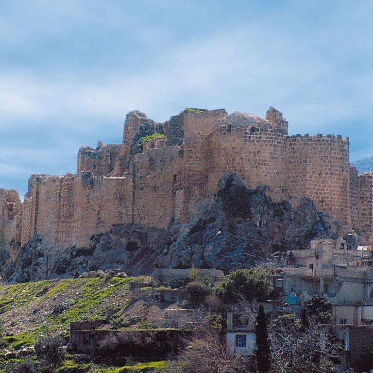
Margat stands about 360 metres above sea level on the summit of a triangular extinct volcanic hill, approximately 2 kilometres from the Mediterranean coast and 6 kilometres south of Banias. Built primarily of basalt, the fortress combines the communal principles of a religious institution with successive defensive enclosures. The outer walls, reinforced by towers, surround approximately 5.7 hectares. The large outer enceinte, or enclosing defensive circuit, forms part of a concentric castle whose inner defenses could support and dominate the lower line.
Outer Fortress and Suburbium
Fortified Suburb
About two-thirds of the hill was occupied by a fortified suburb, or suburbium. European and Syrian Christians, together with Armenians, lived there and built churches and hospitals. Some buildings in the suburb were still inhabited in 1959, and the area remains under archaeological investigation. The outer walls were strengthened by towers, while a fortified outer gate tower closed the western side toward the sea.
Approach and Inner Defenses
The entrance is reached through a curved passage and a gate tower. The Hospitallers’ inner castle occupies the southern part of the summit, where a double defensive wall completely encircles the inner castle hill. These inner walls were built higher than the outer defenses, allowing defenders to cover troops fighting along the lower walls. The arrangement expresses the principle of a concentric castle, in which successive defensive lines reinforce one another.
Inner Castle Buildings
Donjon
The rooms of the inner castle form a ring of vaulted chambers. At the southernmost and most vulnerable point stands a fortified circular residential tower, or donjon, the principal fortified tower of a medieval castle. Its interior rooms are square, and its walls are approximately 6 metres thick. The castellan lived on the first floor, reached by a protected staircase within the walls. A palace wing with reception rooms connected the donjon to the chapel.
Chapel
The chapel occupies the site of a square residential tower built by the Mazoir family. After acquiring the fortress, the Hospitallers demolished that tower and replaced it with the chapel. The building opens from the small western courtyard through a main portal with clustered columns. Its nave has two cross-vaults and ends in an apse, the rounded termination of the chapel, raised by two steps.
In autumn 2007, archaeologists discovered the largest Crusader mural cycle in the chapel on the southern wall between the apse and the first window. The cycle depicts Heaven and Hell and is regarded as among the most important medieval wall paintings in Syria. A separate mural showing Pentecost and the Nativity was found beneath fallen plaster in the northern sacristy, a room for liturgical objects and vestments, in 1978. Excavation of the larger mural ensemble ended in 2009, while restoration has continued.
The depiction of Hell covers approximately 9 square metres and is arranged in three horizontal registers. The upper zone shows hanged sinners suspended from dry trees in a barren forest, while snakes bite their eyes, groins, and mouths as signs of greed, lust, and lying. In the middle zone, a bladed wheel torments the condemned, devils beat them, and four devils boil a bishop in a cauldron. The lowest surviving portion shows two devils watching a knight impaled on a stake. Dark brownish-red and green earth pigments form the background.
The northern wall contains a four-register depiction of Heaven. In its lower three zones, the saved stand with clasped hands in prayer amid radiance. The subject of the upper register remains unidentified, and moisture and plant roots have damaged the plaster, leaving only fragments potentially recoverable. Geometric motifs, heraldic elements, eagles, crosses, and palmettes decorate the apse and nave. Three Crusader-period painting phases have been identified, with the Heaven and Hell cycle belonging to the second. The treatment of flesh tones and the use of pink give the fresco technique a more European than Byzantine character, and the style and imagery indicate the work of a European master.
Dormitory and Residential Range
A dormitory stands beside the chapel on the eastern side of the summit. The knights’ sleeping quarters belonged to the early fortress and were rebuilt twice before reaching their monumental dimensions by 1202. Elegant residential rooms were later built above the eastern vaulted range, together with a bath and a kitchen. The residential area also contained two flush latrines.
Refectory and Kitchen
A two-storey refectory, or communal dining hall, is attached to the western side of the donjon. The knights ate on the upper floor, while the armed sergeant brothers dined below. The kitchen extends from the refectory. Its sink drained through a water conduit sunk into the floor and connected to the drainage system.
Water System
The Hospitallers adapted earlier parts of the fortress to create a complete system for collecting and supplying water. Ceramic pipes carried rainwater into large vaulted chambers cut into the basalt. The inner castle functioned as a water trap, and a large cistern was cut into the rock beneath the central courtyard.
Chapter House and Two-Column Hall
Opposite the dormitory stands the hall-like chapter house, where the knights met for councils. The first chapter house is thought to have collapsed in the earthquake of 1202. Its replacement measured 12 by 36 metres and had a stone cross-vaulted ceiling supported by two rows of pillars. Much of the building has been destroyed, but its form was reconstructed from surviving windows and pillar remains on the seaward side. Beside it stands the castle’s most elaborate room, known as the Two-Column Hall.