Hadrian’s Wall: The Roman Frontier Across Northern England


Visitor Information
Google Rating: 4.6
Popularity: Very Low
Google Maps: View on Google Maps
Official Website: www.nationaltrail.co.uk
Country: United Kingdom
Civilization: Roman
Remains: Military
History
Hadrian’s Wall Path follows the line of Hadrian’s Wall, a Roman frontier built in the 2nd century AD across northern England. The Wall marked the northern limit of Roman Britain under Emperor Hadrian, who ordered its construction to control movement and defend the empire’s boundary. The path near Errington Hill Head, Farm, along the B6318 road near Hexham, lies within this historic frontier zone.
The Wall and its forts served as military bases and administrative centers during Roman occupation. Soldiers stationed at forts such as Housesteads and Birdoswald maintained security and monitored local populations. The Wall’s construction and use continued throughout the 2nd century, with the Vallum earthwork south of the Wall forming part of the defensive system.
After the Roman withdrawal from Britain in the early 5th century, the Wall fell into disuse. Over centuries, stones from the Wall were removed and reused in medieval buildings, including Lanercost Priory. Despite this, sections of the Wall and its forts remained visible in the landscape, preserving the memory of Roman presence.
The site is now part of the Frontiers of the Roman Empire UNESCO World Heritage Site, recognizing its historical importance. The name “Hadrian’s Wall” reflects its association with Emperor Hadrian, while place names along the route, such as Wallsend, derive from their proximity to the Wall’s endpoints.
Remains
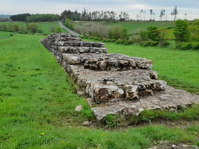
Hadrian’s Wall extends about 84 miles from the east coast at Wallsend to the west coast at Bowness-on-Solway. It is built mainly of stone and earthworks, with surviving sections varying in preservation. The Wall often follows natural features like the Whin Sill escarpment, integrating the landscape into its defensive design.
The forts along the Wall, including Housesteads near Errington Hill Head, date from the 2nd century AD. These forts housed soldiers and contained barracks, defensive walls, gates, and bathhouses. Housesteads is the best-preserved fort, with extensive remains of buildings within its walls and a short public right of way allowing direct access to a preserved Wall section.
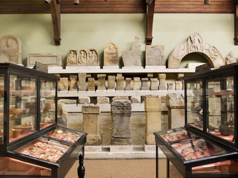
Segedunum fort at Wallsend features a reconstructed bathhouse, illustrating Roman bathing culture. Other forts like Chesters and Birdoswald have excavated remains and on-site museums displaying artifacts such as pottery, tools, and altars, shedding light on military and civilian life.
The Vallum, an earthwork south of the Wall, is often visible along the path. It consists of a large ditch flanked by mounds, forming part of the broader defensive system. Some stones from the Wall were later quarried for medieval construction, notably at Lanercost Priory, showing the reuse of Roman materials.
Today, many remains are fragmentary but consolidated through conservation efforts. The Wall and forts stand in rural settings and urban areas like Newcastle and Carlisle, preserving the legacy of Roman frontier engineering.
Nearby sites