Burgruine Prägrad: A Medieval Fortress in Carinthia, Austria


Visitor Information
Google Rating: 3.7
Popularity: Very Low
Country: Austria
Civilization: Medieval European
Site type: Military
Remains: Castle
History
Burgruine Prägrad is a medieval fortress located on a hill above the village of Prägrad, within the municipality of Feldkirchen in modern-day Austria. It was constructed by medieval German-speaking settlers and ecclesiastical authorities to oversee and protect key routes in the Carinthian region.
The castle first appears in written records in 1166, when Conrad II of Raabs, the burgrave of Nuremberg, sold the stronghold to the Bishops of Bamberg. At the time, the bishops controlled extensive lands in Carinthia and used Prägrad Castle as an administrative center managed by their ministeriales, or appointed officials. The fortress held strategic importance by controlling a vital road running along the southern shore of Lake Ossiach toward the town of Villach.
By the mid-13th century, control of the castle had passed from the Bamberg bishops to the local dukes of Carinthia. Later, in the late 14th century, the Counts of Celje, a powerful noble family from present-day Slovenia, acquired Prägrad. Following the death of Count Ulrich II of Celje in 1456, Emperor Frederick III took possession of the castle. Shortly afterward, Emperor Frederick entrusted the site to the Bishops of Gurk, who in 1468 enfeoffed the property to Jakob von Ernau.
During the Ernau family’s tenure, a new residence was constructed away from the medieval fortress, leading to Prägrad Castle being gradually deserted and falling into ruin. In 1628, ownership of the estate transferred to the nearby Ossiach Abbey, which managed the property until the secularization movements of the early 19th century dissolved many church holdings.
The name “Prägrad” derives from Slavic roots meaning “outer ward” or “settlement before the castle,” suggesting its origins may lie in its role as an advanced defensive site or protective outwork serving the settlement below. This connection hints at an initial function of the castle as a forward fortification guarding access to the area.
Records from the late 17th century, such as the detailed copperplate engraving produced by the scholar Valvasor in 1688, illustrate the castle complex and its associated buildings, including the Pflegerhaus, a late Gothic to early Renaissance administrator’s house standing at the base of the rock.
Remains
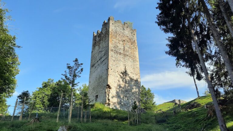
The remains of Prägrad Castle occupy a rocky hilltop overlooking the village below, spread across an area roughly 14.5 by 12.5 meters. The original structure was a modest medieval hill castle built primarily in the 12th century using roughly shaped rubble stones arranged in what is known as shell construction—a technique involving an outer and inner wall filled with loose stones and mortar. Large flat stones mark the corners, adding stability to the construction.
The fortress was enhanced in the late Gothic period, around the middle to the end of the 15th century, with significant remodeling that transformed the original core into a residential tower containing at least four floors. This Wohntrum, or living tower, featured thick walls particularly on the southern side, the most vulnerable approach, measuring close to a meter in thickness. A projecting gatehouse protected the main eastern entrance, reinforcing access control.
Attached directly to the foundation of the tower is a slender annex extending up through each floor that juts eastward, resembling a small round tower called a tortur. This feature likely served defensive or structural purposes by strengthening the entrance area.
On the north side, a rectangular building of economic function was incorporated into an outer defensive zone known as a zwinger—a walled enclosure added around 1400 to provide layered protection. This northern structure had entrances on both the ground and upper floors and was internally divided by a secondary wall, indicating separate spaces or uses within the enclosure. Parts of the zwinger and other outer walls remain visible southeast of the main castle complex, illustrating the multi-tiered defensive design.
The southern curtain wall underwent extensive rebuilding during the late Gothic renovation. However, the southwest corner preserves original medieval masonry, showcasing the contrast between initial 12th-century work and later enhancements. The Gothic wall surfaces exhibit a distinctive net-like stone pattern without the regular horizontal divisions found in other period masonry.
At the foot of the rock once stood the Pflegerhaus, an administrator’s residence from the transitional phase between late Gothic and early Renaissance styles. This building survived until it was demolished in 1967. Presently, the northern face of the residential tower has disappeared entirely, while the southern wall remains largely intact, conveying the castle’s defensive posture and architectural evolution through centuries.