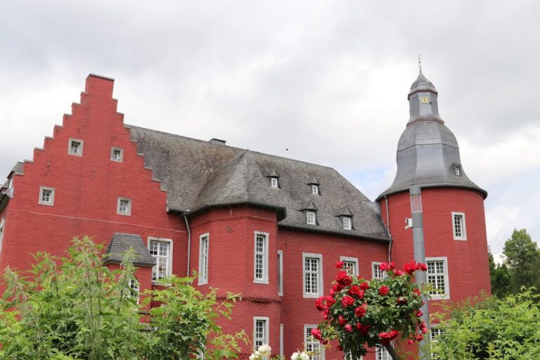
Burg Heinsberg: A Medieval Castle and Fortress in Germany


Visitor Information
Google Rating: 4.3
Popularity: Low
Google Maps: View on Google Maps
Country: Germany
Civilization: Unclassified
Remains: Military

History
Burg Heinsberg is situated in the municipality of Heinsberg in modern-day Germany. It was originally established by medieval Germanic nobility, likely in the 11th century, serving as the family seat of the Lords of Heinsberg.
The initial fortification was a motte-and-bailey castle, constructed primarily from wood and earth. This early structure rested on a naturally elevated spur overlooking the Rur valley. In 1144, during a conflict involving royal forces, Heinrich von Limburg acting on behalf of King Conrad III destroyed the wooden castle. After this event, the site was rebuilt in stone sometime in the 12th century. This reconstruction marked a significant change as builders employed various imported stones including limestone, tuff (a volcanic rock), marl, and sandstone to create a more durable stronghold.
Over the centuries, the lordship of Heinsberg passed through marriage and inheritance to the Duchy of Jülich. From 1484 onwards, Burg Heinsberg became the residence of a bailiff appointed by the Dukes of Jülich, serving an important administrative function within their territory.
In the mid-16th century, the castle gained strategic prominence due to its location near the Spanish Netherlands. Following the election of Wilhelm V as Duke of Guelders in 1538, the fortress and the adjacent town underwent substantial expansion to better withstand military threats. Under the direction of Bertram von Zündorf, a military engineer who also contributed to the fortifications of Düsseldorf Castle, the southern side of Heinsberg was reinforced with bastioned defenses designed to resist artillery. These enhancements included upgraded gates capable of protecting against cannon fire.
Despite these improvements, the town and castle endured damage during the Third Guelders Succession War in 1543 when imperial troops captured Heinsberg and partially destroyed its defenses. There are also indications, though without firm documentation, that French troops may have caused further destruction during the late 17th-century Raubkriege, a series of raids led by Louis XIV in the region.
Today, the site reflects a long history of occupation and conflict, with archaeological layers revealing settlement debris and structural remains spanning from its origins in the 11th century up to the 16th century expansions and battles.
Remains
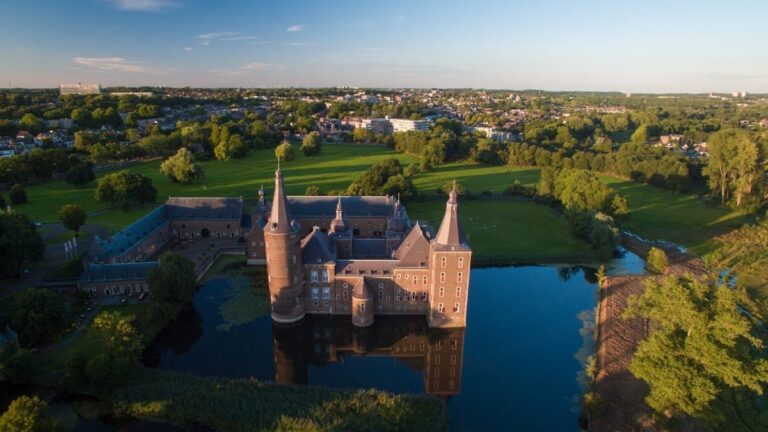
Burg Heinsberg was originally designed as a motte-and-bailey castle, with a main motte or raised earthwork where the primary keep stood. This motte is located on a natural hill spur beside the Rur valley and was artificially heightened by about ten meters to create a strong defensive position, known locally as the Burgberg. Adjacent to the motte, separated by two excavated trenches, lies the Kirchberg, which functioned as the outer bailey—an enclosed courtyard outside the main castle mound—and housed the Gothic collegiate Church of St. Gangolf, built in the 15th century.
The transformation from the original wooden-earth construction to a stone “Randhausburg” took place during the 12th century. This term refers to a castle featuring a ring wall encircling the main residential building. Distinctive for its use of non-native building materials, the stonework includes limestone, tuff, marl, and sandstone, which were brought in to enhance durability and prestige.
In the 16th century, further significant modifications reinforced the town’s southern approaches with bastioned fortifications. These angular defensive structures were specially designed to better resist cannon fire, reflecting advances in military technology of the Renaissance period. The water defenses, consisting of a system of ponds surrounding the eastern and western sides of the settlement, served as natural barriers. Although these water features no longer remain intact, their former presence is remembered in local street names such as Haagweiher and Riedweiher, which reference these ponds (weiher meaning “pond” in German).
The fortified gates of the southern and northern entrances, notable for their curved, bulletproof posterns or small doors, are recorded features of this era. The southern gate, called the Feldtor, was removed in the mid-19th century, while the northern Unterbrucher Tor was demolished towards the end of that century.
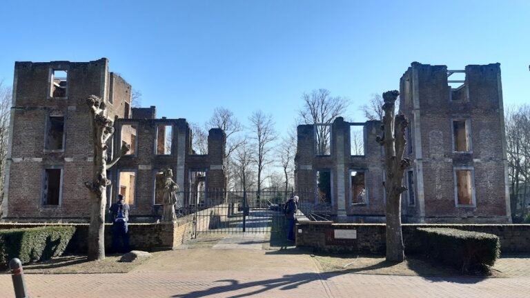
At present, only fragmented walls and portions of both the original castle and the later bastion fortifications survive above ground. Some segments of the town’s defensive walls remain visible as well. Archaeological research has uncovered overlapping evidence of the site’s long occupation, confirming this location as one of the largest remaining motte complexes in the Rhineland. The castle grounds are today protected as an archaeological monument, preserving these relics of medieval and early modern fortification techniques.
Nearby sites