Bridge of Augustus in Narni: An Ancient Roman Bridge in Italy


Visitor Information
Google Rating: 4.6
Popularity: Low
Google Maps: View on Google Maps
Country: Italy
Civilization: Roman
Remains: Infrastructure

History
The Bridge of Augustus is located in Narni, a town in the province of Terni, within the Umbria region of central Italy. It was built by the Romans around 27 BCE during the rule of Emperor Augustus. The bridge was part of the Via Flaminia, a major Roman road connecting Rome to the Adriatic coast, and it spanned the river Nera, a tributary of the Tiber.
The bridge remained in use for nearly a thousand years. Over the centuries, it suffered damage from natural disasters, including floods and earthquakes. In the 7th century, part of the structure collapsed, and further destruction occurred in the 10th century due to a flood. By the Middle Ages, the bridge was partially ruined, prompting the construction of a wooden replacement downstream to maintain the crossing.
In 1855, another flood caused significant collapse, reducing the number of intact arches. During the 20th century, the site saw changes related to modern infrastructure, including the excavation of a railway tunnel through the northern remains. Restoration efforts began in the 1970s, with additional conservation following earthquake damage in 2000 and continuing into the early 21st century.
The bridge attracted artistic attention during the Grand Tour era, inspiring works by painters such as J. M. W. Turner and Jean-Baptiste-Camille Corot. Ancient writers also mentioned the bridge; the poet Martial referenced it in an epigram, noting its position over the sulfurous waters of the Nera river. In the 15th century, historian Flavio Biondo described the structure.
Remains
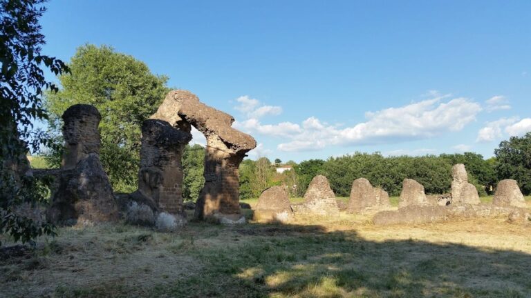
The Bridge of Augustus originally stretched about 160 meters in length and was approximately 8 meters wide on the roadway. It consisted of four arches of different spans, ranging from about 16 to 32 meters. The piers supporting the bridge were roughly 20 meters wide at the base. Today, only the southernmost arch remains fully intact, rising about 30 meters above the river valley. The other arches and piers survive as partial ruins scattered along the riverbanks.
Constructed from large blocks of white marble, the bridge was built without mortar or iron clamps, showcasing Roman masonry techniques that relied on precise stone cutting and fitting. A notable feature of the bridge is the projections at the tops of the piers. These supported wooden beams used during construction to form the stone arches. After the arches were completed, the wooden framework was removed, but the stone projections remain as evidence of this method.
The arches spanning the river were more vulnerable to flood damage and have mostly collapsed, while those on the riverbanks have better preservation. In the 20th century, a railway line was built along the northern bank of the Nera, requiring a tunnel to be cut through the northern remains of the bridge. The site is now protected as a heritage conservation area, with the single complete arch standing on the southern bank and scattered remnants on the northern side.
Nearby sites