Bibracte: The Principal Oppidum of the Aedui in Central France
Table of Contents


Visitor Information
Google Rating: 4.8
Popularity: Very Low
Google Maps: View on Google Maps
Official Website: www.bibracte.fr
Country: France
Civilization: Celtic, Roman
Remains: Burial, City, Civic, Domestic, Economic, Entertainment, Infrastructure, Military, Religious, Sanitation

Context
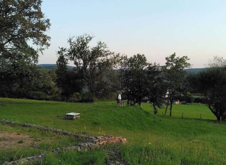
Bibracte is situated near the village of Le Bourg within the commune of Glux-en-Glenne, in the Nièvre department of central France. The site occupies a prominent volcanic plateau atop Mont Beuvray, part of the Morvan massif, a region characterized by dense forest cover and rugged, hilly terrain. This elevated position provided natural defensive advantages and commanding views over the surrounding river valleys, including the basins of the Yonne, Saône, and Loire rivers. The location lies within the modern Bourgogne-Franche-Comté administrative region, approximately 30 kilometers southwest of Autun, the site of the Roman city Augustodunum.
Founded in the late Iron Age, Bibracte served as the principal oppidum of the Aedui, a powerful Gallic tribe. Its strategic placement at the crossroads of major river routes facilitated control over trade and political influence in central Gaul. Archaeological evidence indicates continuous occupation from its establishment in the 2nd century BCE through the early Roman Imperial period. The site’s decline began in the 1st century CE, coinciding with the foundation of Augustodunum nearby, which gradually supplanted Bibracte as the regional capital. The largely forested and undeveloped setting has contributed to the preservation of earthworks and material culture, enabling detailed archaeological investigation into Gallic urbanism and the processes of Roman integration.
Systematic archaeological research has been ongoing since the 19th century, with intensified excavations and conservation efforts managed by the Centre archéologique européen du mont Beuvray. The site’s topography, natural water sources, and extensive fortifications provide critical insights into the political, economic, and religious life of a major Celtic urban center prior to and during Romanization.
History
Bibracte holds significant historical importance as the fortified capital of the Aedui tribe during the late Iron Age. Its establishment atop Mont Beuvray allowed the Aedui to exert control over key trade routes connecting the Mediterranean world with northern Gaul. The oppidum functioned as a political, military, and economic hub until the Roman conquest, after which it underwent a process of Romanization before its gradual decline in favor of the newly founded Roman city of Augustodunum (modern Autun). The site’s history reflects broader regional dynamics of Gallic tribal organization, Roman imperial expansion, and cultural transformation.
Late Iron Age (Late 2nd century BCE – 1st century BCE)
In the late 2nd century BCE, the Aedui established Bibracte as their principal fortified settlement, initially enclosing approximately 200 hectares with a murus gallicus fortification. This defensive wall, characteristic of Gallic hillforts, combined timber framing with stone facing and was accompanied by a substantial ditch. Subsequently, the enclosure was reduced to about 135 hectares with the construction of a smaller inner wall, reflecting urban consolidation and changing defensive needs.
Strategically located at the confluence of the Yonne, Saône, and Loire river basins, Bibracte controlled vital trade corridors linking the Mediterranean to northern Gaul. The oppidum’s population is estimated between 5,000 and 10,000 inhabitants, including aristocratic families, artisans, and druids. The Aedui political system featured a senate representing noble lineages and an annually elected magistrate, the vergobret, who exercised judicial and executive authority within the territory. Druids held influential roles in both religious and political spheres, with notable figures such as Diviciacos serving as military commanders.
Archaeological investigations reveal a complex urban layout adapted to the mountainous terrain, organized along a central axis connecting major gates such as the Porte du Rebout and the Grandes Portes. Specialized artisan quarters near the Porte du Rebout hosted workshops for blacksmiths, bronze workers, enamellers, coin minters, and possibly goldsmiths. Nearby mining sites for gold, iron, and tin ores supported a regional metallurgical economy, with evidence suggesting that metal bars were imported and finished products manufactured outside the oppidum.
The Aedui exercised customs control over goods traversing their territory, as documented by Julius Caesar’s account of Dumnorix, a vergobret responsible for tax farming. Bibracte was a focal point in the Gallic Wars: Caesar defeated the Helvetii nearby in 58 BCE; in 52 BCE, the Gaulish coalition led by Vercingetorix was ratified at Bibracte; and Caesar wintered there in 52/51 BCE, composing his Commentaries on the Gallic War. Despite Roman conquest, the oppidum remained a stronghold of the Aedui for several decades, as noted by Strabo.
Romanization and Early Imperial Period (1st century BCE – 1st century CE)
Following the Roman conquest, Bibracte experienced accelerated Romanization beginning in the late 1st century BCE. Mediterranean architectural techniques were introduced, including stone construction, atria with impluvia (central rainwater basins), hypocaust heating systems, and sewer networks. The Parc aux Chevaux plateau contains several Roman-style stone houses (domus), notably the large domus PC1, which covered approximately 3,500 square meters—about four times the size of typical Pompeian houses—indicating the presence of a wealthy local elite adopting Roman domestic customs.
Between 50 and 30 BCE, a monumental complex comprising a basilica with three naves, an internal peristyle, and a peripheral ambulatory was constructed at the Pâture du Couvent area. This complex, likely serving as a forum, represents the earliest known monumental Roman stone architecture north of the Mediterranean in Europe. The basilica was flanked by two square plazas with porticoes, reflecting administrative and judicial functions aligned with Roman governance. Around 35–25 BCE, this complex was deliberately dismantled and replaced by a large private residence, possibly reflecting the political and administrative shift to Augustodunum.
Despite Roman architectural influences, Bibracte’s urban plan remained irregular, shaped by the mountainous terrain rather than the orthogonal grid typical of Roman towns. The oppidum continued to function as a regional center, with large public warehouses storing imported Mediterranean goods, especially Italian wine transported in amphorae. Religious activity persisted, as evidenced by a Gallo-Roman temple uncovered beneath a 19th-century chapel on the site.
The foundation of Augustodunum around 15 BCE marked the beginning of Bibracte’s decline. The new city, situated in a more accessible plain, became the Aedui’s Romanized capital. The population gradually relocated, and Bibracte was largely abandoned by the end of the 1st century CE. Some cultic functions and aristocratic residences persisted for a time, but the oppidum ceased to be a major urban center.
Medieval Period
During the late Middle Ages, the site of Bibracte hosted a Franciscan convent (Cordeliers) established on Mont Beuvray, which was later abandoned. Although the oppidum was no longer inhabited as a city, the location retained local cultural and religious significance. A medieval fair, documented from the 13th century onward, continued to be held annually in early May, reflecting the site’s enduring role as a regional gathering place.
The toponym evolved through various forms such as Buvrait, Beuvray, and Biffractus, illustrating linguistic changes and Latinization processes over time. Some medieval inscriptions referencing a goddess named Bibracte were discovered in Autun during the 17th century, though their authenticity and connection to the ancient oppidum remain uncertain.
Modern Rediscovery and Archaeological Research (19th century to Present)
Bibracte was definitively identified with Mont Beuvray in 1867 by Jacques-Gabriel Bulliot, overturning earlier hypotheses that placed the oppidum at Autun or Beaune. Bulliot’s excavations, supported by Emperor Napoleon III, focused on the Porte du Rebout and artisan quarters, establishing the site’s extent and significance. His nephew Joseph Déchelette continued research until 1907, pioneering Celtic protohistoric archaeology and comparative studies of European oppida.
After a hiatus following World War I, excavations resumed in 1984 under the patronage of President François Mitterrand, who declared Bibracte a site of national interest in 1985. The establishment of the Centre archéologique européen du mont Beuvray in 1989 integrated the archaeological site, museum, and research center, fostering international collaboration. Modern methods such as airborne lidar scanning and detailed stratigraphic excavation have revealed complex fortifications, urban quarters, and monumental architecture.
The site has been protected as a Monument historique since 1984 and designated a Grand Site de France in 2007. The museum, opened in 1996 and designed by Pierre-Louis Faloci, presents the history of Celtic civilization and the Romanization process at Bibracte. Ongoing research continues to enhance understanding of late Iron Age urbanism and the integration of Gallic societies into the Roman world.
Daily Life and Importance by Period
Late Iron Age (Late 2nd century BCE – 1st century BCE)
During the Late Iron Age, Bibracte functioned as the fortified capital of the Aedui, a Celtic tribe with an estimated population between 5,000 and 10,000. The social structure was hierarchical, dominated by aristocratic families represented in a senate and governed by the vergobret, an annually elected magistrate with judicial and executive authority. Druids held prominent religious and political roles, exemplified by individuals such as Diviciacos, who also commanded cavalry forces.
Economic life centered on artisanal production and trade. Specialized workshops near the Porte du Rebout produced metal goods, including blacksmithing, bronze enameling, coin minting, and possibly goldsmithing. Mining activities in the surrounding hills supplied gold, iron, and tin ores, supporting a regional metallurgical economy. Agriculture supplemented the diet, but Bibracte’s strategic location at the intersection of major river basins enabled control over trade routes. Imported Mediterranean goods, particularly Italian wine transported in amphorae, were stored in large public warehouses, indicating centralized commercial management and customs taxation enforced by the Aedui elite.
Dietary evidence suggests consumption of cereals, locally grown fruits, and imported wine. Clothing likely consisted of woolen tunics and cloaks, consistent with Celtic attire known from regional parallels. Domestic architecture was primarily wooden with earth foundations, arranged along a central axis adapted to the mountainous terrain. Interiors probably featured simple furnishings, with no extensive use of stone or mosaic decoration at this stage. The urban layout included multiple gates and neighborhoods but lacked the regular grid typical of Roman towns.
Religious practices focused on natural springs and fountains, some serving as cultic sites where votive offerings and coins were deposited. A sacred enclosure (nemeton) at the summit, surrounded by palisades and ditches, attests to organized ritual activity. Funerary customs involved cremation with burial enclosures oriented eastward, reflecting Celtic beliefs about the afterlife. Bibracte’s political role was central in the region, hosting significant events such as the confirmation of the Gallic coalition under Vercingetorix and Julius Caesar’s wintering during the Gallic Wars.
Romanization and Early Imperial Period (1st century BCE – 1st century CE)
Following the Roman conquest, Bibracte underwent significant cultural and architectural transformation while maintaining its role as a regional center. The population, still largely of Gallic origin but increasingly Romanized, included a local elite adopting Roman lifestyles, as evidenced by large stone houses (domus) with atria, impluvia, hypocaust heating, and sewer systems, such as the expansive domus PC1. Artisans continued to work near residential areas, indicating a blend of domestic and industrial functions within urban quarters.
Economic activities remained diverse, with continued storage and distribution of imported Mediterranean goods, particularly wine, in public warehouses. The introduction of monumental Roman architecture, including a basilica and forum complex at the Pâture du Couvent, signaled administrative and judicial functions aligned with Roman governance. However, this basilica was dismantled within a few decades, reflecting a political shift toward the newly founded Augustodunum. Despite Roman influences, the city’s irregular urban plan persisted, shaped by the mountainous topography rather than a Roman grid.
Diet and clothing evolved as Roman customs spread; local diets incorporated Mediterranean staples, while clothing styles likely included Roman tunics and footwear alongside traditional Gallic garments. Interior decoration in elite homes featured Roman architectural elements but lacked extensive mosaic floors, possibly due to the site’s peripheral location. Religious practices combined native Celtic cults centered on springs and sacred groves with emerging Gallo-Roman temples, such as the one beneath the later chapel, indicating religious continuity and syncretism.
Bibracte’s civic role diminished as Augustodunum became the new Aedui capital around 15 BCE, chosen for its accessible plain location and alignment with Roman urban models. The population gradually relocated, but some aristocratic families and cultic activities persisted into late antiquity. The oppidum retained a secondary administrative and religious function before its eventual abandonment by the end of the 1st century CE.
Medieval Period
By the medieval era, Bibracte had ceased to function as an urban center but maintained local cultural and religious significance. The site hosted a Franciscan convent during the 15th and 16th centuries, indicating continued ecclesiastical use of the elevated plateau. The population in the surrounding region was predominantly rural, with social organization centered on feudal structures rather than urban governance.
Economic activity at Bibracte itself was minimal, but the annual fair held since at least the 13th century demonstrates the site’s enduring role as a regional gathering place for trade and social exchange. The fair likely facilitated the exchange of agricultural products, livestock, and artisanal goods typical of medieval rural markets in Burgundy.
Religious life was dominated by Christianity, with the convent serving as a spiritual and possibly educational center. The persistence of the toponym in various forms and the discovery of medieval inscriptions referencing a goddess named Bibracte suggest a layering of cultural memory, though direct continuity with ancient cults is uncertain. Domestic life in the nearby villages followed typical medieval patterns, with simple timber or stone houses, subsistence farming, and limited craft specialization.
Modern Rediscovery and Archaeological Research (19th century to Present)
Although not a period of habitation, the modern era has seen Bibracte’s transformation into a focal point for archaeological research and heritage preservation. Systematic excavations initiated in the 19th century revealed detailed aspects of daily life, economy, and urbanism during the Late Iron Age and Roman periods. The establishment of the Centre archéologique européen du mont Beuvray has fostered international scholarly collaboration, applying advanced methods such as lidar scanning and stratigraphic excavation to reconstruct the oppidum’s layout and social organization.
Archaeological findings have illuminated the complexity of Bibracte’s artisanal workshops, trade networks, and religious practices, enriching understanding of Celtic urbanism and Roman integration. The site’s protection as a Monument historique and Grand Site de France underscores its cultural importance. Public education efforts, including museum exhibitions, have disseminated knowledge of Bibracte’s historical role as a political, economic, and religious center, bridging ancient and modern cultural identities in the region.
Remains
Architectural Features
Bibracte’s fortifications comprise two successive murus gallicus walls, a construction technique combining timber frameworks with stone facing and a protective ditch. The initial enclosure, dating to the late 2nd century BCE, encompassed approximately 200 hectares with ramparts extending about 7 kilometers. This outer wall stood 4 to 5 meters high, accompanied by a ditch 2 to 4 meters deep and 6 to 10 meters wide. It was later dismantled to build a smaller inner wall enclosing 135 hectares with about 5 kilometers of ramparts, which survives today. The construction of the inner wall required substantial timber, earthworks, and iron reinforcements.
The urban layout adapted to the mountainous terrain of Mont Beuvray, organized around a central street running from the Porte du Rebout to the Grandes Portes. The oppidum spans three summits, with neighborhoods and gates arranged accordingly. Architectural evolution is evident from primarily wooden and earth constructions in the late Iron Age to stone buildings exhibiting Roman architectural features after the Gallic Wars. The Parc aux Chevaux plateau contains several stone houses, likely aristocratic residences and public buildings, constructed from the late 1st century BCE onward.
Key Buildings and Structures
City Walls and Gates
The murus gallicus fortifications include two main enclosures. The earlier outer wall enclosed about 200 hectares but was replaced by a smaller inner wall enclosing 135 hectares. The surviving inner wall features timber framing with stone facing and a substantial ditch. Approximately fifteen gates punctuated the walls, with the Porte du Rebout being the most extensively excavated.
The Porte du Rebout measures approximately 20 meters in width and 40 meters in depth. Excavations revealed five construction phases, including a Neolithic palisade dated by carbon-14. No definitive evidence of gate closing mechanisms or defensive towers has been found, though a double gate with a wooden watchtower has been hypothesized. A unique postern gate, the only one known for this fortification type, was discovered near the Porrey area. Since 2005, research has focused on an advanced fortification line downstream of the Porte du Rebout, which appears to postdate the gate itself.
Artisanal Quarters of Côme Chaudron and Champlain
Located near the Porte du Rebout, these quarters were specialized metalworking districts active from the late Iron Age into the early Roman period. Excavations since 2000 uncovered workshops for forgers, bronze workers, enamellers, and likely goldsmiths and coin minters. Nearby slopes around the Champlain summit contain mining sites for gold, iron, and tin ores. Evidence indicates that metal bars were imported into the oppidum and cast into finished products outside the city. Another artisanal quarter near the Pierre de la Wivre summit has been identified but remains unexcavated.
Parc aux Chevaux Residential Area
This central plateau on Mont Beuvray contains several stone houses constructed from the late 1st century BCE, reflecting Roman architectural influence. The most notable is house PC1, which evolved from a wooden structure into a large domus covering approximately 3,500 square meters. PC1 features an atrium with an impluvium (central rainwater basin), porticoes, hypocaust heating systems, and a sewage network. It measures about 55 by 67 meters, roughly four times the size of typical Pompeii domus. Around fifteen domus are estimated in this area, including smaller residences like PC2, which faces PC1 across the main street. Villa rustica–type rural houses such as PC33 have also been found. The presence of forges near these houses indicates mixed residential and artisanal use.
Monumental Basin at Pâture du Couvent
Situated on the main street in the Pâture du Couvent area, this basin is carved from pink granite and dates to the late 1st century BCE. Its transverse orientation aligns with the sunrise at the winter solstice and sunset at the summer solstice. Water drained from the basin’s northern outlet into a canalization, though the water source remains unknown. The basin is sealed with a red clay layer, excluding natural spring feeding, and no supply canal has been found. Its geometric design is based on the intersection of two circles and Pythagorean triangle proportions. The granite carving technique is unusual for the region, suggesting involvement of Mediterranean craftsmen. Nearby are numerous cellars and public buildings used for storing cereals and imported wines, including a recently reconstructed wooden cellar.
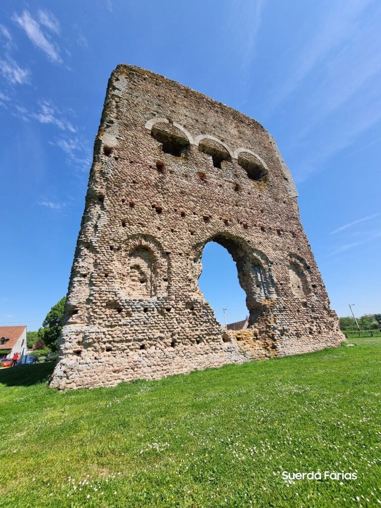
Basilica and Forum Complex at Pâture du Couvent
Constructed between 50 and 30 BCE, this monumental complex centers on a Roman-style basilica, possibly serving as a forum. The basilica has three naves with an internal peristyle and a peripheral ambulatory. It features four rows of eight columns or pilasters. To the east lies a 22-meter square plaza bordered by porticoes aligned with the basilica’s annexes, while to the west is a 17-meter square plaza connecting to the main street of Bibracte. Architectural elements include limestone columns with Attic bases and Doric and Corinthian capitals. Around 35 to 25 BCE, the basilica and plazas were deliberately leveled and replaced by a large private residence, likely reflecting the transfer of the Eduen capital to Augustodunum (modern Autun).
Religious Structures
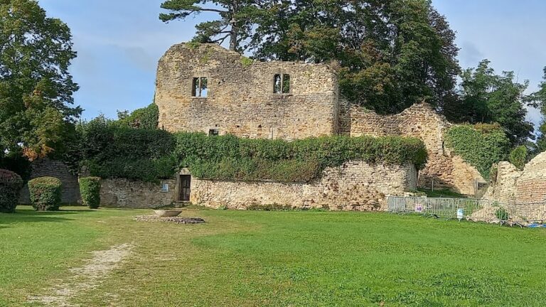
The summit of Mont Beuvray hosts a Celtic sanctuary (nemeton) covering about one hectare, surrounded by a palisade and concentric ditches, dating to the late Iron Age. Excavations in 1988 beneath a 19th-century chapel uncovered a Gallo-Roman temple, indicating continued religious use after the city’s decline. Additionally, five fountains dating from the Gaulish or Gallo-Roman period have been identified, including the Fountain Saint-Pierre, which served as a cult and pilgrimage site where coins and ex-votos were deposited.
Necropolis
The necropolis lies beneath the current museum parking area and covers approximately 1.5 hectares. Rescue excavations uncovered about seventy funerary enclosures, all cremation burials with eastern entrances. Additional cremation sites were found further south. Urns were also discovered below the Porte du Rebout, likely belonging to an aristocratic family. Other cemeteries are suspected along ancient access roads but remain unexcavated.
Medieval Remains
Remains of a Franciscan convent from the late Middle Ages are present on Mont Beuvray. The convent is now abandoned but represents the site’s continued use into medieval times.
Other Remains
Seventeen natural water points, including springs and streams, supplied the oppidum. These fed hydraulic installations such as cisterns, fountains, and wells scattered throughout the site. Ancient hedgerows known as “queules,” visible as twisted trees, mark former pasture enclosures. The urban layout includes multiple gates and neighborhoods adapted to the hilly terrain, with a central street connecting major access points.
Archaeological Discoveries
Excavations at Bibracte have yielded a variety of artifacts spanning the late Iron Age through the early Roman period. Pottery includes locally produced and imported amphorae and tableware, reflecting trade connections. Numerous coins have been found, including those minted by the Aedui and Roman issues from the 1st century BCE onward. Tools related to metalworking, agriculture, and daily life have been recovered, especially in artisanal quarters.
Domestic objects such as lamps, cooking vessels, and personal items have been uncovered in residential areas. Religious artifacts include statuettes, altars, and ritual vessels found in the nemeton and Gallo-Roman temple contexts. Inscriptions are rare but include dedicatory formulas linked to the basilica and religious sites. The metalworking districts produced a range of finished goods, including bronze and iron items, enamels, and coins, indicating specialized craft production.
Preservation and Current Status
The inner murus gallicus wall remains visible and partially preserved, with sections of ramparts and ditches intact. The Porte du Rebout gate has been extensively excavated and stabilized, revealing multiple construction phases. Stone houses in the Parc aux Chevaux area survive as foundations and partial walls, with some hypocaust heating systems and sewage channels preserved. The monumental basin at Pâture du Couvent is well-preserved, though its water supply system remains incomplete.
The basilica and forum complex survive as foundations and column bases, with the original superstructures lost. The nemeton’s palisade and ditches are visible in plan through excavation. The Gallo-Roman temple remains are fragmentary but identifiable beneath the 19th-century chapel. The necropolis enclosures are preserved underground, with urns and cremation remains documented. The Franciscan convent ruins are fragmentary and overgrown.
Vegetation and forest cover protect much of the site but also pose challenges for excavation and conservation. Ongoing archaeological work is managed by the Bibracte Mont Beuvray archaeological center, which conducts systematic excavations, conservation, and research. Some areas have undergone partial restoration, while others are stabilized in situ to prevent deterioration.
Unexcavated Areas
Approximately 90% of the oppidum’s 135 hectares remain unexcavated. Notably, the artisanal quarter near the Pierre de la Wivre summit awaits excavation. Other suspected cemeteries along ancient access roads have not been explored. Surface surveys and geophysical studies indicate buried remains in several sectors, including advanced fortification lines downstream of the Porte du Rebout. Future excavations are planned but limited by conservation policies and the dense forest environment.
The site’s large extent and rugged terrain restrict comprehensive excavation, with research focusing on key areas such as the Rebout quarter, Pâture du Couvent, and Parc aux Chevaux. Modern prospection techniques, including airborne lidar scanning, continue to identify subsurface features for targeted study.
Nearby sites