Archaeological Site of Old Poitiers (Vieux-Poitiers): A Gallo-Roman Settlement in France


Site at a Glance
- Rating
- 3.9
- Popularity
- Low
- Country
- France
- Primary era
- Classical
- Eras represented
- Stone Age, Iron Age, Classical
- Civilizations
- Roman
- Site type
- City
On this page28 sections
History
The Archaeological Site of Old Poitiers (Vieux-Poitiers) is an ancient settlement in France, at Vieux Poitiers in Naintré, developed by the Pictones and later transformed into the Gallo-Roman settlement of Briva. Its main monumental phase belongs to the Early Empire, when the site became a secondary urban settlement and an important centre of circulation, exchange, and craft production within the territory of the Picton people.
Pre-Roman occupation
The area between the Clain and Vienne rivers was occupied from the Neolithic through the Iron Age. Neolithic enclosures and megaliths are followed by an open settlement associated with the Pictones at the end of the sixth or beginning of the fifth century BC. A Late Iron Age sanctuary stood beside a river crossing, probably from the beginning of the second century BC, while domestic remains show continued activity during the first century BC.
The sanctuary included a rough monolithic stele enclosed by a small stone structure. The monument was preserved when the Roman settlement was established. Fragments of a military standard and a carnyx, a long Iron Age trumpet used in military or ceremonial settings, together with weapons and ornaments, indicate associations with a warrior cult.
Briva under Roman rule
During the Gallo-Roman period, the settlement was called Briva, a vicus of the Picton civic territory. A vicus was a Roman secondary settlement that could serve commercial, industrial, administrative, or transport functions. The name Briva comes from a Gaulish word meaning “bridge” or possibly “ford.” The settlement stood beside the Roman road from Poitiers to Tours, between the territories of the Turones and Bituriges Cubi.
Briva developed especially during the Early Empire. Its public and private monumental area covered about 65 hectares, while the wider settlement may have extended across 65 to 80 hectares and supported an estimated population of about 4,000. Its position near the confluence of the Clain and Vienne provided natural protection, access to fishing resources, and opportunities to control commerce and river traffic. Coins from a nearby Picton mint, gold rings associated with Roman civic elites, and extensive evidence of craft and construction reflect commercial activity and the adoption of Roman customs.
The main public buildings were concentrated in the eastern part of the settlement. They included a large theatre and two temples, while ceramic workshops operated in the same broad area. A possible bath complex has also been identified from aerial observations, although its function remains uncertain. The settlement’s streets, buildings, and river facilities formed a crossroads within Picton territory, linking the urban area with routes by land and water.
Fire, rebuilding, and decline
The theatre was built in several stages, probably beginning in the third quarter of the first century BC or later. Recent research places its construction between the third quarter of the first century BC and the end of AD 110. A fire destroyed it around the middle of the second century AD. The building was rebuilt or substantially altered between approximately AD 175 and 200, before ceasing to function during the third century.
During the Late Empire, parts of the theatre were reused for domestic purposes. Its stone was later taken for other construction, and architectural elements from Briva were incorporated into the defensive wall of Lemonum, the Roman city corresponding to modern Poitiers, probably around the transition from the third to the fourth century.
Occupation continued into the Early Middle Ages. In 732, a confrontation between the army of Charles Martel and forces of the Umayyad Caliphate may have taken place nearby, although the exact location is uncertain. In 742, Carloman and Pepin the Short used the place name Vetus Pictavis when they divided the Frankish kingdom. By the end of the Merovingian period, the urban and political centre had gradually moved to another site farther north near a bridge over the Vienne, and the former settlement was progressively disused. The later form Vieux-Poitiers appears from 1524 onward.
Archaeological investigation and protection
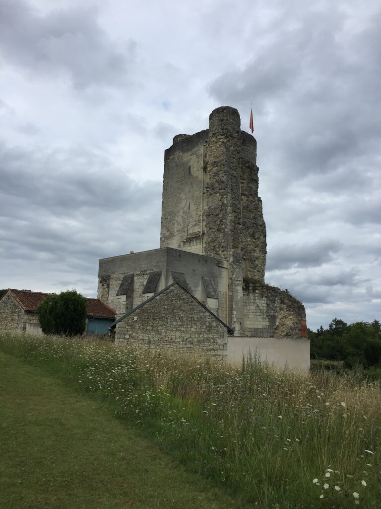
Interest in the site extends at least to the eighteenth century, when the Pierre Levée megalith was discovered in 1783. Nineteenth-century investigations revealed Iron Age, Gallo-Roman, and funerary remains, as well as parts of the Roman road. In 1932, excavators recognized the square tower known as the “masure de Vieux-Poitiers” as one corner of the Roman theatre.
Research continued during the 1940s, from 1963, around 1975, and until 1985 under René Fritsch. Excavations resumed in 1995 under the patronage of Christophe Belliard and exposed most of the theatre’s orchestra and stage area. Subaquatic investigations of the probable port zone have taken place since 2012. The Pierre Levée was classified as a historic monument in 1892, parts of the theatre were classified in 1970 and listed in 1971, and the Souhé menhir-polisher was listed in 1989. Founded in 1987, the Association for the Safeguarding of the Vieux-Poitiers Archaeological Site has supported exhibitions and public interpretation.
Remains
Settlement layout and transport
The settlement occupied a broad depression in the Poitou Threshold, near the right bank of the Clain and the left bank of the Vienne. Its urban area followed an approximately orthogonal grid, although differences in street orientation indicate several phases of development. Aerial archaeology has revealed blocks, or insulae, in three principal size groups, approximately 50 by 38 metres, 80 by 38 metres, and 120 by 60 metres. Some densely occupied blocks contained basilica-like public buildings opening onto streets, while other blocks included cellars, pits, and ditches later filled with sediment.
Roman road
A stone-paved Roman road about 4 metres wide crossed Briva on the route between Poitiers and Tours. Its slabs were joined with hard mortar. The complete route extended for approximately 102.3 kilometres, or 42 Gaulish leagues. Near Cenon-sur-Vienne, at least two milestones dated to AD 123, during the reign of Hadrian, marked the road.
River installations
River infrastructure included a possible quay discovered in 2007 at Cenon, about 50 metres upstream from the confluence of the Clain and Vienne and 8 metres from the bank. The rectangular structure is approximately 13 metres long and 1.70 metres wide. It consists of two rows of blocks, with each block measuring about 1.50 metres long, 0.50 metres wide, and 0.50 metres thick.
A second installation at Naintré probably dates to the first or second century AD. Its carefully built abutments rested on a platform of oak piles and were associated with a ford formed by a roadway approximately 6 metres wide. Together, these structures provide physical evidence for movement between the settlement and its river environment.
Neolithic and Iron Age monuments
Neolithic enclosures
Two possible Neolithic enclosures have been identified. The enclosure at Les Longères lies on an alluvial terrace and consists of three parallel ditches. Its central V-shaped ditch is about 1.50 metres wide and 0.50 metres deep, and contained pottery fragments, flint objects, and antler artefacts. The enclosure at Marchais consists of three sections of a single ditch separated by wide openings, although its Neolithic date remains unproven.
Pierre Levée
The Pierre Levée is a flattened, yellowish sandstone monolith approximately 2.66 metres high, 4.50 metres long, and 0.66 metres wide. When it was discovered, about 2.50 metres of the stone was buried between the Clain and the ancient ruins. Its roughly triangular form has a rounded upper end, fissures, and cavities.
A Gaulish inscription written in Latin characters runs across the stone. It states that Frontu, son of Tarbeisa, dedicated the ratis of the inhabitants of Briva. The meaning of ratis is uncertain. It has been understood as a raised earthwork, fortification, roadway, or, in view of the nearby river installation, a ford. The dedication may have been an act of benefaction to the vicus community.
Souhé menhir-polisher
The Souhé menhir-polisher is a flat monolith approximately 2.50 metres high, 1.60 metres wide, and between 0.40 and 0.60 metres thick. Found in 1965, it is made of reddish Cenomanian sandstone probably extracted at Noirpuis, about 2 kilometres away. The stone was leaning northwest at an angle of about 45 degrees and has ten polishing zones on its lower right side, including three grooves and seven hollows. It is arranged symmetrically with the Pierre Levée across the Clain.
Iron Age buildings
A square Iron Age building excavated between 1970 and 1974 survives as a cellar with postholes. Used during the first century BC, it contained a bronze pendant, a bone pin with a gold head, coins, and a fibula. The building lay beneath the northeastern structures of the theatre and was probably reused before being dismantled during the Roman period.
Another Late Iron Age private building at Les Fonds des Berthons included a cellar with postholes and a well. The well contained part of a sculpture, fragments of a relief, a silver fibula, and coins. The building was demolished and reused during the Gallo-Roman period.
Religious buildings
Les Berthons temple
The rural Gallo-Roman temple at Les Berthons was built during the Julio-Claudian period. Columned porticoes along its sides, including exedrae, enclosed a broad sacred esplanade. A cult deposit dating between the first and third centuries AD contained a bowl with a funnel-like feature. A bronze architectural element covered with gold leaf, probably from a roof or wall revetment, measures approximately 33 by 18 centimetres and has square perforations and two male fixings.
Religious objects
Other cult material from the settlement includes fibulae, harness fittings, tools, coins, a possible figurine of Apollo, and a small bronze votive statue of Epona. Epona was a Gallo-Roman goddess associated particularly with horses and equestrian protection. The statue is 5.8 centimetres long and 5.5 centimetres high, and depicts the seated goddess on an equid wearing a long garment.
The theatre
Structure and seating
The theatre is a semicircular, hollow-structured building approximately 116 metres in external diameter, built into a slope between elevations of about 67 and 72 metres. It could accommodate approximately 10,000 spectators, making it one of the largest theatres in Gaul and larger than the theatre at Orange. Its construction combined cut stone with extensive timber elements, and its architectural form has no exact parallel in surviving ancient treatises.
The cavea, the theatre’s seating area, is approximately 115 metres in diameter. It contains 31 wedge-shaped seating sectors separated by 15 passageways leading into them. Aerial observations revealed seven concentric walls crossed by radial walls. Wooden tiers rested on a masonry framework of intersecting semicircular galleries with radial openings. The central section had a monumental facade.
Fire and reconstruction
A charcoal layer about 10 centimetres thick, approximately 30 centimetres below the modern ground level, preserves evidence of the fire that damaged the theatre in the mid-second century. It contained structural nails and fragments of modillion cornices. A lower layer, about 15 centimetres beneath it, contained successive fills associated with the destruction and reconstruction of a concentric wall, including cut-stone fragments and limestone chips.
Stage and orchestra
The stage occupied an area approximately 8.50 metres long and 18 metres wide. Its foundations consisted of four parallel masonry structures and had no proscenium. In the first construction phase, the stage rested on blocks measuring about 1.25 by 0.85 by 0.34 metres. After the fire, a pit at the base of the rear wall was filled with masonry approximately 0.90 metres thick.
The stage stood more than 1 metre above the orchestra, probably requiring wooden stairs. The difference in level may also reflect the removal of large ashlar blocks once joined with dowels and mortises. Fragmentary columns, a continuous base for a row of columns, and plinths indicate a portico or colonnade behind the stage. Corinthian capitals found near the front suggest an architectural decorative scheme, while flat roof tiles formed the roof.
The hemispherical orchestra measured approximately 26 metres in diameter and covered about 900 square metres in its first phase. It initially had a stucco-like stone surface and was entered through a corridor on the west. Its foundations consisted of two courses of limestone rubble bonded with mortar over green local Cenomanian sand. Construction required terracing to a depth of about 6 metres. A pavement survives between the central radial corridor and the first concentric wall.
Theatre finds
Objects found near the theatre include an uninscribed silver token, coins dating from Nero to Hadrian, a small bronze shield with a human-headed boss possibly depicting a gorgon, bronze rings that may date to the Late Empire, wooden structural nails, an iron sling projectile, and ceramic objects. These finds accompany fragments of architectural decoration, including marble revetment, cornices, mosaics, and green marble mouldings.
Craft production and domestic areas
Ceramic workshops
Ceramic workshops were concentrated in the eastern part of Briva and operated from the reign of Tiberius until the end of the second century AD. Four direct-reduction furnaces were identified, including two at Les Groseillers. The workshops produced pottery with regular, uniform fabrics resembling wares from the lower and middle Loire valleys. A clay roller discovered in 2008 was used to create linear decoration. The workshops also yielded Early Imperial amphorae of Pascual 1 and Dressel 2/4 types, probably made at a regional pottery.
Streets and dwellings
Preventive excavations near the theatre exposed a partly paved street network between urban dwellings, together with several pits. One dwelling wall stood over a ditch probably dug at the end of the Iron Age. The streets may have connected the urban area with the river crossing or bridge at Les Fonds des Berthons.
Burials and funerary features
Late Imperial burials
Two Late Imperial burials were discovered in a former sand quarry in the late 1990s. One contained a woman and the other a girl. Each was placed in a lead coffin inserted into a stone sarcophagus, with both coffins occupying a single chamber lined with masonry.
The girl’s burial included embroidered fabric with gold thread, woven materials, corded sandals, ceramic and bronze vessels, a bronze basin, an antique toy chest, and a basket. The objects preserve evidence of the materials and personal belongings placed with the deceased during the Late Empire.
Eastern cemetery enclosure
Aerial photography has revealed a possible rectangular cemetery enclosure on the eastern edge of the settlement beside the Roman road. It measures approximately 0.2 kilometres by 0.1 kilometres. A possible cippus, a small stone monument that could serve a funerary or commemorative purpose, was found nearby in the 1960s, and a small bronze knife in its sheath was discovered in the 1980s. The enclosure’s precise funerary interpretation remains uncertain.