Ambrussum: A Strategic Celtic and Roman Site in Southern France
Table of Contents


Visitor Information
Google Rating: 4.5
Popularity: Medium
Google Maps: View on Google Maps
Official Website: www.ambrussum.fr
Country: France
Civilization: Celtic, Roman
Remains: Burial, City, Civic, Domestic, Economic, Entertainment, Infrastructure, Military, Religious, Sanitation
Context
Ambrussum is situated near the modern village of Villetelle in the Hérault department of southern France, occupying a prominent limestone plateau known as the Colline de Devès. This elevated terrain overlooks the Vidourle River valley, providing a strategic vantage point that controlled access to the surrounding plains and river crossing. The site’s position adjacent to the Vidourle and its fertile Mediterranean environment supported agricultural activities and access to natural resources, factors that influenced its long-term occupation.
Archaeological investigations have demonstrated continuous human presence at Ambrussum from the late Neolithic through the Roman period. Initially established as a fortified Celtic oppidum during the Iron Age, the site later became integrated into the Roman provincial infrastructure, notably as a key crossing on the Via Domitia, the earliest Roman road in Gaul. Although occupation declined during late antiquity, the site’s well-preserved fortifications, roadworks, and settlement remains provide critical evidence for understanding regional settlement dynamics and Roman transportation networks in southern Gaul.
Since the 20th century, systematic excavations and conservation efforts have revealed the site’s complex stratigraphy and architectural features. Ambrussum is now recognized as a significant archaeological monument, offering insights into the cultural transitions from Celtic to Roman control and the adaptation of local communities within imperial systems.
History
Ambrussum’s historical trajectory reflects the broader cultural and political transformations of southern Gaul from the late prehistoric period through the late Roman Empire. Initially a fortified Celtic settlement, it evolved into a Romanized site integrated within the province of Gallia Narbonensis. Its strategic location on a limestone plateau overlooking the Vidourle River made it a critical point for controlling regional access and facilitating movement along the Via Domitia, the principal Roman road connecting Italy to Hispania. Over time, Ambrussum transitioned from a defensive oppidum to a Roman staging post before experiencing decline in late antiquity amid environmental and infrastructural challenges.
Prehistoric and Protohistoric Occupation (c. 2600–300 BCE)
Archaeological evidence attests to human activity at Ambrussum beginning in the late Neolithic period (circa 2600–2200 BCE), with lithic artifacts characteristic of the Ferrières culture recovered from the summit of the Colline de Devès. The site maintained occupation through the Bronze Age (1200–800 BCE), as indicated by decorated ceramic vessels and an Italic bronze fibula found near the future bridge location, suggesting early long-distance contacts predating Greek colonization of southern Gaul. During the Early Iron Age (6th–5th centuries BCE), ceramic fragments including Etruscan amphora shards and Greek painted cups demonstrate ongoing cultural exchanges within the Mediterranean sphere. These findings position Ambrussum within a network of interactions that laid the groundwork for later urban development.
Celtic Oppidum Period (4th–1st century BCE)
In the late 4th or early 3rd century BCE, the Volcae Arecomici, a Celtic tribe inhabiting Mediterranean Gaul, established a fortified oppidum at Ambrussum encompassing approximately 5.6 hectares. The settlement was enclosed by a substantial dry-stone limestone rampart, originally featuring square towers, which were replaced by rounded towers in the mid-3rd century BCE. Two notably taller towers functioned as watchtowers and likely symbolized elite status within the community. The oppidum’s internal layout included terraced housing adapted to the hillside topography and a cemetery located in the flood-prone lower area, where at least seven cremation tombs of individuals of varying ages and sexes have been excavated.
Ambrussum minted its own coinage inscribed with the legend “AMBR” in both Greek and Latin scripts, indicating a degree of local political autonomy and early adoption of Roman or Latin legal frameworks by the 1st century BCE. The oppidum was part of the Volcae Arecomici territory, whose principal city was Nemausus (modern Nîmes), situating Ambrussum within a regional Celtic polity that maintained economic and cultural connections across southern Gaul.
Roman Conquest and Early Roman Period (c. 120 BCE – 1st century CE)
Following the Roman conquest of the region around 120 BCE, Ambrussum was incorporated into the newly established province of Gallia Narbonensis. The Romans constructed the Via Domitia, the earliest Roman road in Gaul, linking Italy to Hispania and passing near Ambrussum. The site became a critical crossing point over the Vidourle River, facilitating military and commercial movement. Circa 30 BCE, the Pont Ambroix, a monumental stone bridge with eleven arches, was erected to replace an earlier wooden structure, underscoring the site’s infrastructural importance.
Under Roman influence, the oppidum underwent significant urban remodeling. The residential area was reorganized, and a paved main street approximately 200 meters in length was constructed around 100 BCE, connecting the east and south gates with a gradient of about 9%. The south gate was enlarged to open onto a forum area featuring a civil basilica, reflecting the introduction of Roman civic architecture. Housing evolved from simple Celtic-style dwellings to Roman domus with internal courtyards; notably, large residences of approximately 400 square meters were built in the southern oppidum around AD 50. Despite these developments, the oppidum was abandoned by around AD 100, likely due to shifting settlement patterns favoring lower-lying areas and the growth of nearby urban centers such as Nemausus. However, the lower settlement near the river remained occupied.
Gallo-Roman Staging Post and Lower Settlement (1st–4th centuries CE)
At the base of the oppidum, a substantial Roman staging post (mutatio) developed along the Via Domitia, serving travelers, the Imperial postal service (cursus publicus), and local inhabitants. Constructed around 30 BCE, the complex included multiple inns with courtyards for animals and guests, a blacksmith’s workshop specialized in carriage repair, a bread oven, and a bathhouse equipped with hypocaust heating supplying the caldarium and laconicum. One inn’s south gallery featured painted wall decorations and yielded a purse containing 43 denarii, indicating use by official travelers.
Archaeological evidence also reveals agricultural and metallurgical activities within the staging post, including a hand mill, a large hearth possibly used for forging, and a circular kiln or oven. The settlement was repeatedly rebuilt and protected by embankments due to frequent flooding of the Vidourle River, which intensified after approximately 10 BCE. The staging post remained in use until at least the 4th century CE, undergoing renovations and functional adaptations even as the oppidum above was abandoned.
Late Antiquity and Medieval Period (4th–15th centuries CE)
During late antiquity, the Pont Ambroix continued to facilitate river crossing but suffered progressive destruction from violent floods known locally as Vidourlades. Originally comprising eleven arches, the bridge was reduced to a single surviving arch by the 20th century. The Via Domitia remained in use but was gradually supplanted by alternative routes such as the Camin de la Monnaie, which bypassed the oppidum to the south.
Documentary and archaeological evidence attest to a Christian presence near the bridge, including the church of Sancte Marie de Ponte Ambrosio recorded in 1156 and a monastic establishment of nuns dating to 1254. These institutions indicate a shift from the site’s earlier civic functions to religious community organization. The bridge and associated road station fell into disuse due to changing transit patterns and repeated flood damage. A 1390 notarial act accuses local inhabitants of damaging the bridge, reflecting its decline during the medieval period.
Modern Rediscovery and Archaeological Excavation (19th century–present)
The Pont Ambroix was recognized as a historic monument in 1840 by Prosper Mérimée, yet the oppidum and lower settlement remained largely unexplored until the 20th century. Early excavations by Dr. Émile Marignan uncovered remains spanning from the Neolithic to Roman periods but were followed by a hiatus. Systematic archaeological investigations resumed in 1967 under Jean-Luc Fiches, revealing the oppidum’s fortifications, paved streets, domus houses, and the staging post complex. Excavations continued annually through the 1980s and beyond.
Since 2011, a visitor center and museum designed by Michel Goroneskoul have presented the site’s history and archaeological findings. Recent conservation efforts include the delicate removal and restoration of painted Roman wall plaster dating between 20 and 10 BCE and stabilization of the Pont Ambroix to prevent further deterioration. The site is protected as a classified historic monument and remains an active focus of archaeological research and heritage management.
Daily Life and Importance by Period
Celtic Oppidum Period (4th–1st century BCE)
During the Celtic oppidum phase, Ambrussum was inhabited by the Volcae Arecomici, a Celtic people of Mediterranean Gaul. The community resided within fortified limestone ramparts, occupying terraced housing adapted to the hillside. The presence of two prominent watchtowers suggests a social hierarchy, with elite families likely residing near these structures.
Roman Conquest and Early Roman Period (c. 120 BCE – 1st century CE)
Following Roman conquest, Ambrussum underwent urban transformation reflecting Roman planning and social organization. The main street was paved, and the south gate enlarged to open onto a forum with a civil basilica, indicating the introduction of Roman civic institutions. Housing evolved into Roman-style domus with internal courtyards; large residences of approximately 400 square meters suggest the presence of a wealthy, possibly Romanized elite. Although specific magistrates are not attested epigraphically, the architectural evidence implies a stratified society with local governance.
Economic life expanded through integration into the Roman provincial system. The Via Domitia and Pont Ambroix enhanced commercial and military transit, positioning Ambrussum as a key river crossing. Agricultural production likely included grain, olives, and vineyards, supporting local consumption and trade. Craft activities such as pottery and metalworking adapted to Roman demand. Diet incorporated Mediterranean staples including bread, olives, wine, and fish. Clothing shifted toward Roman fashions, with tunics and togas for elites. Painted wall plaster and mosaic floors in domus reflect increased domestic comfort and decoration. Religious life incorporated Roman deities alongside local cults, with public rituals likely held in the forum, although no temples have been excavated. By around AD 100, the oppidum was abandoned, possibly due to the rise of nearby urban centers and changing settlement preferences.
Gallo-Roman Staging Post and Lower Settlement (1st–4th centuries CE)
After the oppidum’s abandonment, daily life centered on the lower settlement at the foot of the plateau, which developed into a Roman staging post (mutatio) along the Via Domitia. The population comprised travelers, postal couriers, artisans, innkeepers, and agricultural workers. Social organization focused on service provision, with inns, stables, a forge specialized in carriage repair, and a bathhouse with hypocaust heating.
Economic activities were diverse, including bread baking, blacksmithing, and agricultural processing. Painted wall decorations and the discovery of a purse with 43 denarii indicate commercial prosperity. The settlement’s economy was closely tied to the road network, facilitating regional trade and communication. Diet remained Mediterranean, with bread, olives, and wine predominant. Clothing reflected Roman provincial styles. Interiors featured painted plaster and functional layouts suited to hospitality and repair services. Transport relied on horse-drawn vehicles and foot traffic, with the Pont Ambroix enabling efficient river crossing. Religious practices are poorly documented but likely included informal observances associated with communal spaces such as bathhouses.
Late Antiquity and Medieval Period (4th–15th centuries CE)
In late antiquity, the lower settlement and Pont Ambroix continued to serve travelers despite progressive flood damage. Population decline and shifting trade routes, including the rise of the Camin de la Monnaie, reduced the site’s importance. Christian institutions emerged, evidenced by the 12th-century church Sancte Marie de Ponte Ambrosio and a 13th-century nunnery, marking a transition from civic to religious community organization. Economic activities contracted, focusing on monastic sustenance and local agriculture. Transport diminished, and social customs adapted to Christian liturgical practices. By the late medieval period, the site was largely abandoned as a civic center, with the bridge in ruin and the road station defunct. A 1390 notarial act accusing locals of damaging the bridge reflects the decline of communal infrastructure maintenance.
Remains
Architectural Features
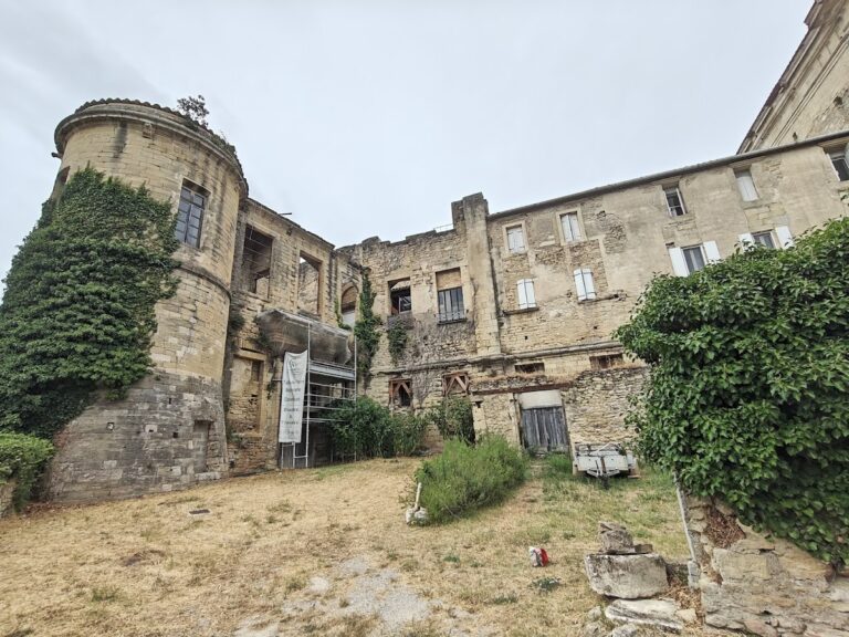
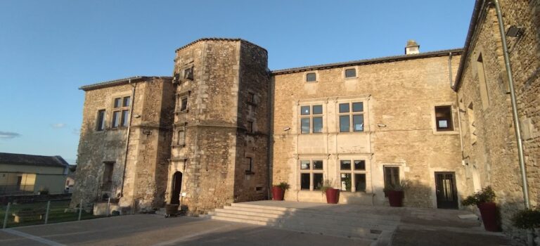
Ambrussum occupies the Colline de Devès, a limestone plateau where the remains of a fortified oppidum extend over approximately 5.6 hectares. The defensive system comprises a dry-stone limestone rampart originally constructed in the 4th century BCE, reaching about 7.5 meters in height. This fortification includes 21 towers and 24 bastions; early square towers were replaced by rounded ones in the mid-3rd century BCE. Three principal gateways—north, south, and east—provided controlled access, with the south gate enlarged during the Roman period. The eastern rampart has been partially dismantled, likely due to historic quarrying for lime production.
The oppidum’s roughly triangular layout features terraced housing adapted to the hillside. Residential structures evolved from early square dwellings with branch and reed roofing to narrower Roman-style courtyard houses (domus) by the 1st century BCE. A paved main street approximately 200 meters long and 3.05 meters wide runs from the east gate to the south gate, curving to follow the terrain with a gradient of about 9%. Wheel ruts are visible near the east gate, which originally led toward the Vidourle River bridge but now ends abruptly due to riverbank erosion. The lower settlement near the river contains remains of a Roman staging post (mutatio) built circa 30 BCE, including inns, workshops, and a bathhouse, all repeatedly rebuilt due to frequent flooding.
Key Buildings and Structures
Oppidum Ramparts and Gates
The oppidum’s fortifications consist of two successive walls: the initial 4th-century BCE wall with square towers and a 3rd-century BCE wall featuring rounded towers, restored twice in the 2nd century BCE. Two taller towers served as watchtowers and status symbols. The three gateways—north, south, and east—regulated access, with the south gate enlarged in the Roman period to open onto the forum. Surface traces of ramparts and towers remain visible, though some eastern sections have been heavily quarried.
Paved Main Street
Constructed around 100 BCE, the main street inside the oppidum extends approximately 200 meters from the east gate to the south gate. It is paved with stone slabs, about 3.05 meters wide, and curves to accommodate the natural slope. The street’s gradient is roughly 9%, and visible wheel ruts near the east gate attest to vehicular use. The street originally connected to the Vidourle River bridge but now terminates due to erosion.
Forum
The forum, dating to the 1st century CE, lies adjacent to the south gate. It is partly paved and surrounded by a portico and public buildings, serving as a civic center. Excavations have revealed its layout as a square open space bordered by structures. Stones from a civil basilica located behind the south gate were later reused in the 2nd century CE at the lower settlement’s staging post.
Large Courtyard Houses (Domus)
Three large domus-style houses, each approximately 400 square meters, were excavated in the northern oppidum. Built in the mid-1st century CE and occupied until around 100 CE, these residences feature central courtyards and Roman architectural elements. One house, discovered beneath the forum levels, contained painted red wall plaster dated between 20 and 10 BCE. The houses include painted wall decorations and mosaics, indicating architectural refinement.
Civil Basilica
The civil basilica, constructed in the 1st century CE behind the south gate square, served a public or administrative function. Only fragmentary remains survive, with stones later repurposed in the 2nd century CE for construction at the lower settlement’s staging post.
Staging Post on the Via Domitia
Located in the lower settlement near the Vidourle River, the staging post (mutatio) was built around 30 BCE to serve travelers and the Imperial postal service. The complex includes two main buildings and two courtyards, with the south gallery walls decorated with painted frescoes. A purse containing 43 denarii was found in this gallery, indicating use by official travelers. The staging post underwent renovations and possible repurposing in the 4th century CE after the oppidum was abandoned.
The site contains multiple inns: one with a courtyard for animals and carts and five guest rooms remained largely unchanged from 30 BCE to 125 CE. Two additional inns dating from 200 to 250 CE were found closer to the river. The settlement also includes a bathhouse with hypocaust (underfloor heating) supplying hot air to the caldarium and laconicum. Although mostly beneath a modern road, the bathhouse’s heater chamber (praefurnium) remains visible.
A blacksmith’s courtyard house, known as the “Maison de Charron,” specialized in carriage building and vehicle repair. Active from 25 to 175 CE, it contained a forge and yielded weapons, suggesting possible military connections. The staging post was protected by embankments constructed to mitigate frequent flooding of the Vidourle River. Archaeological evidence also includes a bread oven and traces of agricultural and metallurgical activity.
Pont Ambroix (Roman Bridge)
The Pont Ambroix, constructed circa 30 BCE, originally spanned the Vidourle River with eleven stone arches over approximately 150 meters. The arches measured about 10 meters wide and 9 meters high. Built using precisely cut stones placed without mortar (dry joint technique), the bridge relied on gravity and weight for stability. It remained intact through the Middle Ages but suffered progressive destruction from floods known as Vidourlades. By 1620, only four arches remained; by 1857, two arches survived. A flood in 1933 destroyed one of the last two arches, leaving a single arch standing today.
Restoration efforts in 2019–2020 removed vegetation, including a fig tree that threatened the structure, and stabilized the remaining arch. In 1983, archaeological teams recovered 112 stone blocks from the riverbed, which were relocated in 2017 to prevent loss due to riverbank erosion. The bridge is classified as a French National Monument.
Necropolis
The necropolis is located in the lower, flood-prone area near the staging post. Excavations uncovered seven cremation tombs containing remains of children, adolescents, and adults of both sexes. Gaulish weapons were found near the bridge area, linking the cemetery to the Celtic period contemporary with the oppidum.
Other Remains
Additional remains include surface traces of the oppidum’s ramparts and towers, visible in several locations around the hill. A small votive altar dedicated to Fortuna by a woman named Petale Antonia was found within the staging post complex. Remains of a small medieval church, Sancte Marie de Ponte Ambrosio, documented in 1156, lie south of the bridge. Nearby, archaeological evidence of a nunnery dating to 1254 has been excavated, including associated medieval buildings.
Traces of agricultural and metallurgical activity are present, such as a circular oven and a large hearth, likely used for forging or processing materials. The lower settlement’s street plan aligns with Roman cadastral grids and decumani roads, reflecting organized urban planning. Visible chariot wheel ruts are preserved in the paved road at the foot of the oppidum.
Preservation and Current Status
The oppidum’s ramparts and towers survive in varying states, with some sections well-preserved and others heavily damaged or looted. The paved main street and forum area have been excavated and partially conserved. The large domus houses retain structural remains and fragments of painted wall plaster, some of which have undergone recent restoration. The civil basilica survives only in fragmentary form, with stones reused elsewhere.
The staging post’s buildings, including inns, bathhouse, and blacksmith’s workshop, are partially preserved, though some lie beneath modern infrastructure. The bathhouse’s heating chamber remains visible. The Pont Ambroix’s single surviving arch has been stabilized through recent conservation efforts, including removal of damaging vegetation and repositioning of displaced stone blocks. The recovered stone blocks from the riverbed are stored to prevent further loss.
Environmental threats include riverbank erosion and flooding, which have historically damaged the lower settlement and bridge. Vegetation growth has posed risks to masonry stability but has been managed through targeted interventions. The site is protected as a classified historic monument, with ongoing archaeological research and conservation overseen by local heritage authorities.
Unexcavated Areas
Several areas of the oppidum and lower settlement remain unexcavated or only partially studied. Surface surveys and geophysical studies suggest buried remains beneath the plateau and floodplain, including possible extensions of residential quarters and infrastructure. The eastern rampart area, heavily quarried in the past, may contain subsurface features yet to be explored.
Modern developments and environmental conditions limit excavation in some zones, particularly near the river. Future archaeological campaigns are planned to focus on the oppidum’s public quarter and social spaces, as well as further investigation of the lower settlement’s urban layout. Conservation policies prioritize stabilization and protection over extensive new excavations in sensitive areas.
Nearby sites