Dun Ringill: An Iron Age and Medieval Fort on the Isle of Skye


Visitor Information
Google Rating: 4.6
Popularity: Very Low
Official Website: www.isleofskye.com
Country: United Kingdom
Civilization: Celtic, Medieval European
Site type: Military
Remains: Fort
History
Dun Ringill is situated on the Strathaird peninsula of the Isle of Skye in Scotland. This site was originally constructed by Iron Age peoples around the start of the Common Era, reflecting the architectural style of brochs—large, round stone towers found along the Atlantic coast.
During the early centuries of its existence, Dun Ringill likely served as a well-fortified residence or stronghold. The site saw ongoing use and adaptation throughout the Middle Ages, becoming closely associated with Clan MacKinnon. Historical records confirm that from at least the 14th century, Dun Ringill functioned as the clan’s seat, with references appearing in texts from the 16th century. During this period, the clan established a nearby farming settlement north of the dun, which supported the community and its activities.
By the 1500s, the MacKinnon family shifted their primary residence to another stronghold known as Dunakin (also called Moll Castle or Dun Acainn). However, Dun Ringill remained part of their holdings and was strengthened in the late medieval period. This phase included the addition of defensive features such as a ditch cutting across the promontory and construction of rectangular buildings within the fortification. These upgrades reinforced its function as a promontory fort, a defensive site built on a headland bordered by natural cliffs or slopes. Modifications and occupation of the site continued up to the 19th century, with archaeological surveys revealing structures from various phases of use overlapping the original broch remains.
Remains
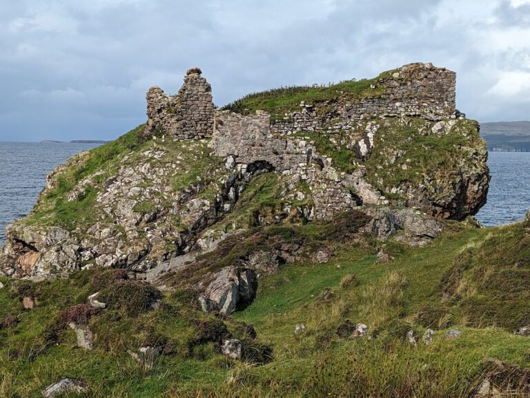
Dun Ringill consists of the ruins of a stone-built fort located on a coastal promontory overlooking Loch Slapin. The main surviving structure is a square-shaped tower about 16 meters across and standing roughly 4 meters high. It is constructed from carefully piled stones without mortar, a method typical of Iron Age brochs. Alongside this tower, an outer ditch runs following the line of the wall, adding another layer to the site’s defenses.
Access to the fort is through a landward-facing entrance nearly 1.8 meters tall. The doorway includes a small guard cell to one side and post holes which once secured a locking mechanism for the door. Inside the enclosure, there are two rectangular stone buildings measuring approximately 4.5 by 2.4 meters. Built into the wall is a corbelled cell—a small chamber topped with a crag-stone vaulted roof created by overlapping stones inward until they meet, providing sturdy shelter within the thick walls.
Around the adjacent area, the remains of a low stone wall mark what is believed to have been a combined defensive perimeter and enclosure for livestock. Though much of this wall is now hidden beneath vegetation, its foundation reveals careful planning to protect animals close to the settlement. On both sides of the fort, earth and stone ramps slope down towards the sea, allowing inhabitants direct access to the water. This arrangement would have been critical for transportation and resupply by boat, the primary means of travel before roads connected the region.
The irregular form of the fort follows the natural contours of the headland, demonstrating how builders adapted their construction to fit the rugged coastline. Excavations conducted in recent times have uncovered remains of additional buildings whose styles and construction phases span the entire period from the original Iron Age setup through to later medieval and relatively modern activities. This long span of occupation reflects the site’s continuous strategic and domestic importance across many centuries.
Nearby sites