Eilean Donan Castle: A Scottish Highland Fortress on Loch Duich


Site at a Glance
- Rating
- 4.6
- Popularity
- Very High
- Country
- United Kingdom
- Primary era
- Medieval
- External website
- Open
- Eras represented
- Medieval, Modern
- Civilizations
- Kingdom of Scotland
- Site type
- Military
- Remains
- Castle
On this page16 sections
History
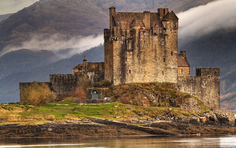
Eilean Donan Castle is a Scottish fortress on a tidal island in Loch Duich near Dornie, United Kingdom. Begun around 1220 during the reign of Alexander II, it was built as a defensive stronghold against Norse incursions and became closely associated with the Mackenzies of Kintail. Its name means “Donnan’s Island,” referring to Donnán of Eigg, a Christian holy man traditionally commemorated as a martyr in 617. A small Christian cell may have existed on the island during the sixth or seventh century, while the castle itself was built over an earlier fortification that may have been Pictish.
The Mackenzies and the medieval fortress
From the thirteenth century, Eilean Donan was connected with the Mackenzies of Kintail. Earlier claims involving the Earl of Ross, the Macraes, and the Maclennans also shaped control of the castle, but Mackenzie possession is documented from 1266. The Macraes and Maclennans became close allies of the Mackenzies, and the Macraes served as their principal protectors. Clan tradition links the castle to the aftermath of the 1266 Treaty of Perth, through which Magnus VI of Norway ceded the Hebrides to Scotland. According to that tradition, the Earl of Ross attacked Eilean Donan after Kenneth Mackenzie refused to surrender it, but the Mackenzies and their allies repelled the assault.
Robert the Bruce is traditionally said to have taken refuge at Eilean Donan during the winter of 1306–07 or 1307–08 while avoiding English forces during the Scottish Wars of Independence. The extent of Mackenzie support for him remains uncertain. In 1331, Thomas Randolph, Earl of Moray, sent an official to announce an approaching visit. Fifty alleged criminals were executed in preparation, and their heads were displayed on the castle walls until Moray approved the action.
During the fourteenth century, the Mackenzies contested Kintail and Eilean Donan with the Earls of Ross. Kenneth Mackenzie, the third chief of Kintail, was executed at Inverness in 1346, while his son Murdo later restored the family’s position. A charter said to have confirmed Murdo’s rights to Kintail and Eilean Donan in 1362 has not survived. The Macraes began settling collectively in Kintail during this period after moving from the Beauly Firth region. Kinship and marriage alliances strengthened their connection with the Mackenzies, leading to their reputation as the clan’s “shirt of mail.”
Royal pressure and clan conflict
In 1427, King James I detained the Highland chiefs whom he had summoned to Inverness. The young Alexander Mackenzie, sixth chief of Kintail, was sent to Perth for schooling, and Duncan Macaulay held Eilean Donan for him. Alexander later supported the monarchy against the MacDonalds and was confirmed in his position by a charter of 1463.
Conflict within the Mackenzie lordship brought further pressure on the castle. After Hector Roy Mackenzie attempted to seize Mackenzie lands and installed Malcolm Mac Ian Charrich Macrae as constable, the Mackenzies were declared rebels. In 1503, the Earl of Huntly offered to capture Eilean Donan for the Crown with naval support from James IV. The castle surrendered after a short siege. John of Killin received a new charter for Kintail and Eilean Donan in 1509, and Christopher Macrae became constable around 1511.
Donald Gorm Macdonald of Sleat attacked the castle in 1539 after raiding Mackenzie territory. The garrison initially consisted only of the constable, Iain Dubh Matheson, and the keeper. Duncan MacGillechriosd Macrae then arrived and killed several attackers at the rear gate. Matheson and the keeper were killed by arrows, but Duncan wounded Donald Gorm with his last arrow, forcing the MacDonalds to withdraw.
The Mackenzie–MacDonald of Glengarry feud began in 1580 and continued for almost twenty-five years. Around 1602, Eilean Donan was used as the base for an action in the Kyle Rhea strait led by Duncan Macrae. The MacDonalds were driven towards Skye, and Angus MacDonald of Glengarry was killed.
The castle under the Seaforths
Farquhar Macrae was born at Eilean Donan in 1580. After studying at Edinburgh and entering holy orders, he became constable of the castle and minister of Kintail in 1618. Colin Mackenzie of Kintail was created Earl of Seaforth in 1623, and he regularly visited the castle with a retinue of about 300 to 500 people, whom the constable was expected to entertain. In 1635, George Mackenzie, the second Earl of Seaforth, appointed Farquhar tutor to his six-year-old son Kenneth, who was subsequently brought up at Eilean Donan.
During the civil wars of the mid-seventeenth century, the Earl of Seaforth supported Charles I. In 1650, the Scottish Parliament ordered a garrison at Eilean Donan, but local resistance drove the soldiers out. The following year, Simon Mackenzie of Lochslin gathered royalist troops near the castle and pressured Farquhar Macrae to leave. Farquhar was the last constable to live there before its reconstruction, although he remained minister of Kintail until his death in 1662.
The castle was briefly occupied by the Earl and Countess of Balcarres during the royalist Glencairn rising. In June 1654, General Monck, Oliver Cromwell’s military governor in Scotland, marched through Kintail while suppressing the rising. His troops destroyed property and seized 360 head of Farquhar Macrae’s cattle.
Destruction and reconstruction
During the Jacobite rising of 1715, William Mackenzie, fifth Earl of Seaforth, supported the Jacobite cause. Jacobitism was the movement seeking the restoration of the Stuart dynasty after its removal from the British throne. Mackenzie and Macrae men gathered at Eilean Donan before the Battle of Sheriffmuir, where the rebellion failed and 58 Macraes were among the Jacobite dead.
In April 1719, about 300 Spanish soldiers commanded by George Keith, Earl Marischal, occupied Eilean Donan in support of the Jacobites. The expected Highland rising and the main Spanish invasion force did not materialize. On 10 May, HMS Worcester, HMS Flamborough, and HMS Enterprise bombarded the castle after its garrison fired on a boat sent under a flag of truce. The naval force captured the stronghold after roughly one to two days, took the surviving Spanish soldiers prisoner, and used 27 barrels of gunpowder to demolish the castle. The remaining Spanish forces were defeated at the Battle of Glen Shiel on 10 June.
Lewis Petit’s survey drawings of 1714 show Eilean Donan largely roofless and ruinous, with only a small entrance building still roofed. That building was demolished four years later, and the castle remained in ruins until the twentieth century. Lieutenant-Colonel John MacRae-Gilstrap acquired the ruin in the early twentieth century and began restoration. Reconstruction took place between 1919 and 1932, incorporating a new arched stone bridge and a war memorial to Macrae soldiers who died in the First World War.
Eilean Donan opened as a museum in 1955. Ownership passed to the Conchra Charitable Trust, established by the Macrae family, in 1983. The castle has held Category A listed-building status in Scotland since 1971, a designation applied to buildings of exceptional national architectural or historic interest.
Remains
Island enclosure and early defences
Eilean Donan stands on a small rocky island, or tidal islet, in Loch Duich in the western Scottish Highlands. At high tide, only a small area of the island remains above water, and a stone pedestrian bridge now connects it with the shore. The earliest castle enclosed most of the land above the high-water line within a roughly 3,000-square-metre ring wall, a continuous defensive wall around a fortified site. Surviving sections remain in the northern part of the island, while other sections became part of later construction.
Keep and defensive towers
Foundations in the northern part of the enclosure indicate a keep measuring about 12 by 13 metres. Foundation remains also point to defensive towers at the northeastern and southwestern corners, although their original height is unknown. The first entrance probably passed through a waterside gate in the northwestern section of the ring wall. A second possible access point lay beside a small beach in the southwest. Excavations in 2008 and 2009 confirmed much of the proposed early layout and found evidence of metalworking in the northern part of the castle.
The medieval tower house
During the fourteenth century, a tower house was built against the ring wall on the island’s highest point. It measured approximately 16.5 by 12.4 metres and had walls about 3 metres thick. Its vaulted ground floor was divided into two rooms, and a stair in the northern part provided access to probably two upper storeys. This tower formed the main residential and defensive building within the earlier enclosure.
The reduced enclosure and later additions
Probably in the late fourteenth or early fifteenth century, the larger ring-wall enclosure was replaced by a smaller defensive enclosure measuring about 25 metres square. Its entrance was on the east, while the reason for the reduction is unknown.
Constable’s house and southwest buildings
A small house was added in the southeastern corner during the sixteenth century. A circular stair connected it with the wall-walk, the protected passage along the top of a fortification wall, and the building probably served as the constable’s residence. An L-shaped building was added in the southwestern corner, possibly in the early seventeenth century. Its southern section extended beyond the ring wall, while its northern wing may have been added later within the enclosure.
East bastion and entrance route
In the late sixteenth century, the castle was enlarged with an east-facing bastion, or projecting gun platform, also described as a hornwork. This angular fortification strengthened the approach at a time when cannon were becoming increasingly important in warfare. The irregular hexagonal structure measured up to about 11.5 metres and connected with the eastern part of the castle through a walled triangular court.
The hornwork contained a well more than 10 metres deep and about 5 metres in diameter. A movable bridge covered the well and formed part of the defensive entrance. During the seventeenth century, this route was abandoned in favour of a more convenient entrance in the southern wall.
The reconstructed castle
The present buildings follow the surviving historic ground plan, but several details differ from the original structures. Lewis Petit’s 1714 drawings were discovered only shortly before reconstruction was completed, so the restorers primarily relied on nineteenth-century plans by David MacGibbon and Thomas Ross.
South entrance and courtyard
The present entrance lies on the south side, through a portal that could be secured by a portcullis, a vertically sliding defensive grille. Above it are the arms of John MacRae-Gilstrap and a Gaelic inscription translated as, “So long as there is a Macrae inside, there will be no Fraser outside.” The entrance opens into a courtyard whose level was lowered to align with the tower house entrance. The southeastern buildings reproduce the form of earlier structures, including the circular stair tower, but are larger. A small additional tower occupies the northwestern corner of the ring wall.
Residential interiors and southwest platform
Only the southern part of the former L-shaped building was reconstructed in the southwest as a simple three-storey house. The site of its northern section is now an open platform overlooking Loch Duich. Inside the castle, the arrangement follows the original dimensions. The formerly divided ground floor is now a single vaulted room called the accommodation hall, while the first floor contains a heraldic dining hall with an oak ceiling and a fifteenth-century-style fireplace.
Memorial and later interpretation
A war memorial to Macrae soldiers killed in the First World War stands near the castle. It carries lines from John McCrae’s poem In Flanders Fields and is flanked by grey field guns. The reconstructed buildings and their setting have also served as filming locations for productions including The Master of Ballantrae (1953), The Private Life of Sherlock Holmes (1970), Highlander (1986), Loch Ness (1995), Braveheart (1995), The World Is Not Enough (1999), and Made of Honor (2008).