Castell de Montoliu: A Medieval Fortress in La Riera de Gaià, Spain


Visitor Information
Google Rating: 4.1
Popularity: Low
Google Maps: View on Google Maps
Country: Spain
Civilization: Unclassified
Remains: Military

History
The Castell de Montoliu, located in the municipality of La Riera de Gaià in Spain, is a medieval fortress constructed by the Catalan civilization. Its origins and early history are closely tied to the political and military developments of the region during the 11th and 12th centuries.
The castle first appears in historical records in 1118 under the name “Monteolivo” in a donation made by Count Ramon Berenguer III of Barcelona to Bishop Oleguer of Barcelona. At that time, it marked the eastern boundary of the territory of Tarragona along with the castle of Tamarit. Some historians suggest that the site correlates with a castle mentioned in 1060 as Ullastrell, granted to Bernat Amat de Claramunt by Counts Ramon Berenguer I and Almodis with the obligation to build a fortress. This earlier document outlines territorial limits that align closely with the location of Montoliu, hinting at its establishment in the mid-11th century.
During the 12th and 13th centuries, the Claramunt family maintained control over the castle. Various members appear in legal documents and feudal agreements, including Deodat and Guillem de Claramunt. By 1229, Guillem was recognized as lord of Montoliu and other nearby castles, solidifying the family’s regional influence. The castle’s ownership was subject to disputes in the mid-13th century. For example, in 1244 Archbishop Pere d’Albalat acquired parts of the surrounding lands, and conflicts involving Guillema de Claramunt and Ponç de Cervera continued through 1251, requiring mediation by the notable friar Ramon de Penyafort, a respected religious figure.
The castle also has ties to significant historical military figures. Berenguer de Montoliu commanded a Catalan fleet during the late 13th century under Alfonso the Liberal and James II, playing a part in the reconquest of Tarifa in 1292. Centuries later, in 1453, Bernat de Montoliu is noted for guarding the port of Constantinople, showing the family’s ongoing martial role extending beyond the local region. Additionally, in 1611, the Archbishop of Tarragona ceded the tithes, or church taxes, of the Monte Olivo territory to Guillem de Claramunt, indicating continued ecclesiastical and feudal interactions well into the early modern period.
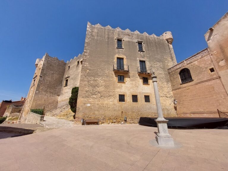
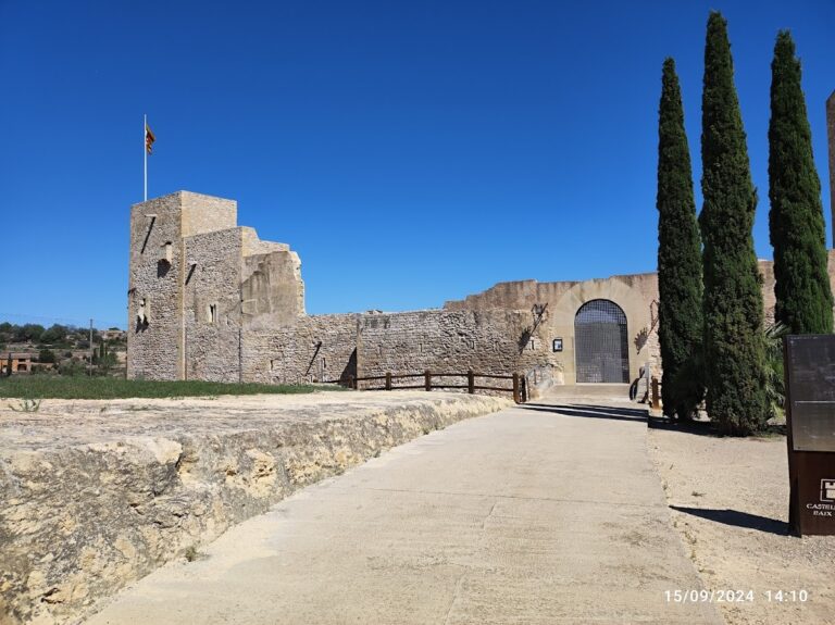
Remains
The Castell de Montoliu occupies a strategic position overseeing a vast territory stretching from the Gaià River to the Francolí River and encompassing lands from Alcover and Valls to Tamarit and Tarragona. This large domain included multiple feudal holdings and related castles, reflecting the fortress’s importance in medieval territorial organization.
At the heart of the site stands a circular tower dating back to the 11th century. Its interior measures 3.5 meters in diameter, and the walls are thick—approximately 1.7 meters at the ground level. Although its current height is only 3.9 meters, the tower likely once rose above 10 meters. Notably, the entrance was placed about 5 meters above the ground, a defensive feature typical of the period to limit access. The tower was built using carefully cut ashlar blocks, roughly 15 by 30 centimeters in size, arranged in even courses, highlighting the craftsmanship and structural design of the era.
Surrounding this central tower is a rectangular enclosure about 30 meters long from south to north and 15 meters wide. Along the western wall, a vaulted chamber extends some 5.6 meters in length and 1.6 meters in width. Above this lower room is a second vaulted hall measuring 6.75 by 4.3 meters, with walls between 85 and 100 centimeters thick. These adjoining rooms may have served as storage or living areas connected to the tower, their vaulted ceilings providing structural strength and fire resistance—features common in medieval castle design.
The southern boundary of the enclosure remains well preserved, marked by a nearly square tower at the southeast corner, reinforcing this section’s defensive capabilities. Extending from the eastern wall is a projecting segment approximately 4 meters deep and 10 meters long. The perimeter walls of the enclosure measure about 1 meter thick, suggesting these walls were considerably taller when constructed.
Architectural details reveal a mixture of building techniques. While the prominent tower was constructed with finely cut masonry, other parts of the castle incorporate roughly shaped stones. Most walls and halls date from the 12th or 13th centuries, exhibiting characteristics of the Gothic style, which emerged during this era. These medieval remains provide physical evidence of the castle’s phases of expansion and adaptation over time in response to the changing needs of its feudal lords.
Nearby sites