Château du Hugstein: A Medieval Fortress in Buhl, France


Visitor Information
Google Rating: 4.4
Popularity: Low
Google Maps: View on Google Maps
Country: France
Civilization: Medieval European
Remains: Military
History
Château du Hugstein stands in the municipality of Buhl, France. This medieval fortress was established by the Murbach Abbey, a powerful Benedictine monastery of the Holy Roman Empire, as both a residence and a strategic stronghold.
The castle’s origins date back to 1227, when Hugo von Rothenburg served as prince-abbot of Murbach Abbey from 1216 to 1236. Appointed by Emperor Frederick II, Hugo combined religious authority with secular power, and he built the castle to oversee the entrance to the Murbach valley and the nearby town of Guebwiller. This initiative marked the abbey’s assertion of control in the region and established Château du Hugstein as the oldest monastic castle recorded in Alsace. It continued to serve as a residence for successive abbots of Murbach. In 1313, Abbot Conrad von Stauffenberg dedicated the castle chapel to Saint Benedict and the Holy Cross, highlighting the site’s religious importance alongside its defensive purpose.
In the 15th century, Abbot Barthélémy d’Andlau undertook significant upgrades to the castle’s defenses. Between 1447 and 1476, he added a decorated gate tower featuring a drawbridge, reinforced the fortress with two new towers, and constructed an outer wall. These improvements reflected the need to strengthen the castle against evolving military threats and to maintain its role in regional security.
During the early 16th century, under Abbot Georg von Masmünster, the fortress gained a darker function by serving as a prison for heretics. Those accused of Protestant beliefs or witchcraft were confined within its walls during a period marked by religious conflict and persecution.
The year 1542 brought violent upheaval when the castle became the focus of a dispute over succession between Heinrich von Istetten and Rudolf Stoer von Stoerenberg. A siege culminated in the capture and imprisonment of Istetten. Following these events, the abbot is believed to have overseen the castle’s partial destruction within the same year, signaling the end of its strategic prominence.
Further damage struck in 1598 when lightning caused structural harm. The Thirty Years’ War (1618–1648) brought additional destruction through vandalism and neglect. By the 18th century, the castle was abandoned as a residence and fell into disrepair. It was subsequently occupied by impoverished residents and later dismantled, its stones reused in local buildings.
Efforts to preserve the site began in 1862, when archaeological clearing uncovered painted decorations that had been concealed over centuries. Recognizing its historical value, authorities designated the ruins as a protected Monument historique in 1898. In 2006, a preservation group named Pro Hugstein was formed to safeguard the remains for future generations.
Remains
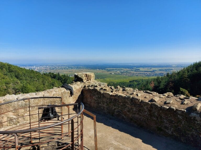
Perched on a rocky outcrop at 389 meters above sea level, Château du Hugstein occupies approximately 50 by 100 meters and consists of a two-part fortified layout. This includes an outer bailey, known in German as a Vorburg, and an inner bailey (Kernburg). These sections are enclosed by a double ring wall, with steep ditches guarding the south and west sides, exploiting the natural terrain to enhance defense.
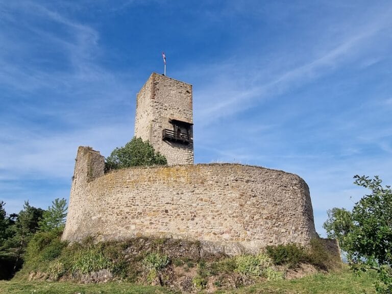
The inner fortress is rectangular, measuring roughly 18 by 25 meters, and rises several meters above the lower outer bailey. It is surrounded by a stout inner ring wall, which stands up to 10 meters tall and measures 2.6 meters thick. Notably, three corners of this wall are rounded so that from a distance they resemble cylindrical towers. This design aimed to confuse attackers by creating an illusion of fully rounded towers, although only a single tower was truly circular in shape.
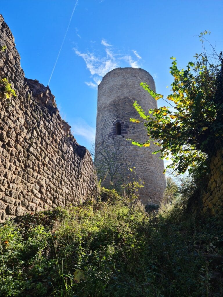
That genuine round tower, called a bergfried, measures around 10 meters in diameter and rises up to 10 meters in height. Positioned on the western side, which was considered the main direction of attack, it was built with carefully hewn sandstone blocks. The wall facing outward was noticeably thicker for added protection, while the side facing the inner courtyard was thinner. Much of its sandstone facing was removed during the 18th century to supply local builders with stone.
Connecting the bergfried to the residential quarters was once a covered gallery, now lost, but during 19th-century repairs, fragments of wall paintings with red-brown vine motifs were discovered in this passageway. The residential building itself likely rose two or three stories along the southern edge of the inner courtyard.
A gate tower, dating from the 15th century remodeling, originally contained three stories though only two remain. Built of rubble stone interlaced with brick, it features sandstone elements that highlight decorative features such as a round-arched entrance and a brick frieze with cornerstones of sandstone. Additionally, simple blind tracery ornamentation can still be seen. The tower was equipped with a drawbridge and a smaller pedestrian door, while its exterior walls contain narrow arrow slits and small shooting windows designed for defense.
The castle’s chapel, dedicated to Saint Benedict and the Holy Cross as recorded in 1313, is believed to have been housed in a rectangular structure along the eastern side of the inner bailey. A Gothic keystone carved with the image of the Agnus Dei (Lamb of God) from this chapel has been preserved and is exhibited at the Musée Théodore Deck in nearby Guebwiller.
Throughout its construction, the fortress relied heavily on locally quarried gneiss stones for the walls, typically used as rubble and often plastered over. Sandstone blocks were reserved for facing and decorative touches, adding texture and definition to the structure. Over time, much of the outer ring wall and two towers on the western side have been dismantled almost completely. Many sandstone door and window frames were forcibly removed and repurposed, altering the castle’s original appearance.
Finally, the castle’s location straddles the communal boundary between Buhl and Guebwiller, with the administrative border actually running through the bergfried. This unique setting reinforces the castle’s historical role in overseeing and controlling access between these neighboring communities.
Nearby sites