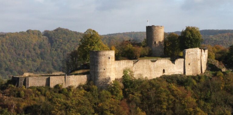
Löwenburg: A Medieval Hill Castle Ruin near Bad Honnef, Germany


Visitor Information
Google Rating: 4.7
Popularity: Medium
Official Website: www.burgen-web.de
Country: Germany
Civilization: Medieval European
Site type: Military
Remains: Castle
History
Löwenburg is a medieval hill castle ruin situated near Bad Honnef, Germany. It was constructed by the Counts of Sayn in the 12th century as a strategic border fortress during a period of frequent territorial conflicts.
The castle’s origins trace back to the latter half of the 1100s, when Heinrich II, Count of Sayn, established it to counter the influence of nearby fortifications held by the Electorate of Cologne. Its first official mention appears in a document dated August 29, 1247, where it is referred to as “castrum Lewinberg” amid the division of the Sayn family’s estates. The document records Countess Mechthild of Sayn retaining residence rights within the castle, signaling its ongoing importance.
Throughout the 13th century, significant construction shaped Löwenburg’s core elements, including its main castle complex, surrounding outer bailey, and northern defensive ring. By 1269, the property passed to Mechthild’s nephews, members of the Counts of Sponheim-Heinsberg lineage, who adopted the title Lords of Löwenburg. Their primary residence was in the nearby town of Honnef, with a secondary seat in Merheim, indicating the castle’s role within their regional power network.
Ownership of Löwenburg changed multiple times in the following centuries. By 1484, it came under the control of the Duchy of Jülich-Berg, where it functioned as the administrative center for the local district known as Amt Löwenburg until the mid-1500s. Military conflicts at the close of the 16th century inflicted substantial damage on the structure, causing it to fall into a state of ruin.
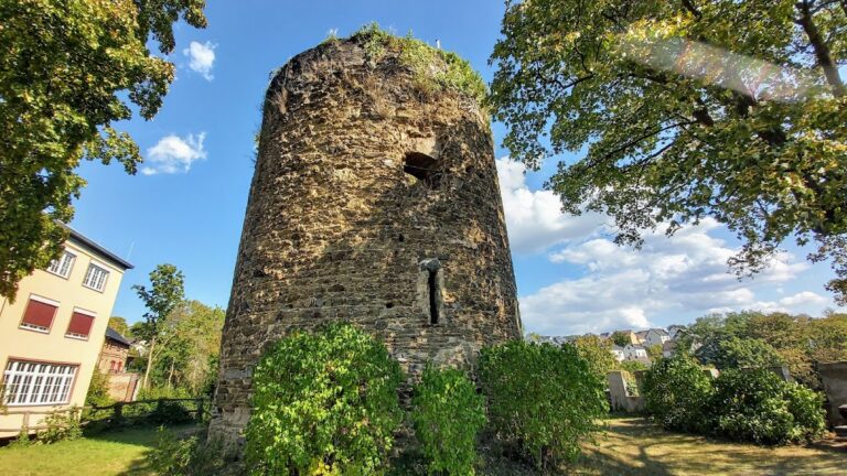
In the 19th century, efforts to preserve the castle faced challenges; partial demolition of the bergfried, or main tower, occurred in 1832 and again in 1881 due to structural weaknesses following unsuccessful preservation attempts. However, some conservation was performed in 1834. From 1861, the Royal Prussian Forestry Office Siebengebirge took charge of the site, conducting restoration work in 1862 and a significant stabilization campaign between 1897 and 1901. A viewing tower was added atop the highest point in 1906, though it was likely destroyed during combat toward the end of World War II in 1945. Additionally, in 1939, an anti-aircraft observation post was established within the upper castle area.
After the dissolution of Prussia in 1947, ownership transferred to the state of North Rhine-Westphalia. By the early 1950s, overgrowth had made the ruin difficult to reach, prompting plans for improved access. Between 1979 and 1985, a major phase of conservation and archaeological excavation was undertaken through collaboration between the state forestry authorities and the Bonn State Building Authority, with oversight provided by the Rheinisches Landesmuseum. The restored site was officially reopened in October 1985. In the late 1980s, sculptor Sigrid Wenzel created bronze plaques depicting the castle’s original appearance.
Further investigations in 2013 addressed damage to the bergfried’s remaining stump, combining masonry repairs with archaeological digs. These excavations uncovered approximately a dozen fragments of Siegburg stoneware pottery, which are now displayed in local museums. During this work, modern surveying techniques such as tachymetry and photogrammetry were used to create precise records of the ruin’s condition.
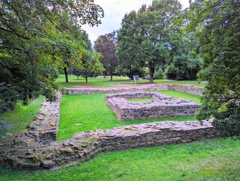
Remains
Löwenburg occupies an elevated, man-made plateau that stretches roughly east to west atop a volcanic hill formed from ancient lava deposits known as nepheline-latite. The main castle sits at the western and highest point of this plateau, while the outer bailey extends along the lower western area. Access to the site is traditionally achieved by a steep, circular path winding around the mountain’s slope. Traces remain of an older hollow way, marking the original route up to the fortress.
Defensive features include a neck ditch carved into the southwest side below the outer ring wall. This trench served as the first barrier against attackers and also provided material for construction; its adjacent latite quarry is still visible in the landscape today. The castle walls were primarily built from rough latite stones quarried directly at the site, lending the structure a distinctive volcanic rock appearance. In contrast, certain architectural details, such as window and door frames in the palas (the main residential building), were crafted from imported materials including trachyte and volcanic tuff, chosen for their refined quality.
The bergfried, or central tower, was founded on a roughly 10 by 10 meter base, but it now survives only as an uneven stump after partial demolition in the 19th century. Within the courtyard lies a preserved cistern, which would have stored rainwater vital for the castle’s inhabitants.
The ruin is designated as a protected cultural monument (Bodendenkmal), reflecting its archaeological and historical importance. A 1906 observation tower once crowned the highest point of the site, but it was destroyed during World War II hostilities. Archaeological excavations in 2013 recovered fragments of Siegburg stoneware vessels from within the interior of the bergfried as well as in the zwinger, a fortified enclosure south of the tower, providing insight into the material culture of the castle’s residents. Precise modern surveying, including tachymetric measurements and photogrammetry, has documented the ruin’s current state in detail.
Historical visual records of Löwenburg include a 1629 etching by Wenzel Hollar, based on an earlier watercolor, which offers a glimpse into the castle’s former appearance during the early modern period. Together, these remains and sources preserve Löwenburg as a witness to medieval fortification, noble residence, and regional history.
Nearby sites