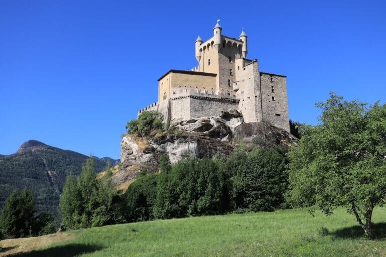
Châtel-Argent: A Historic Hilltop Fortress in Villeneuve, Italy


Visitor Information
Google Rating: 4.4
Popularity: Low
Google Maps: View on Google Maps
Official Website: www.lovevda.it
Country: Italy
Civilization: Medieval European
Remains: Military

History
Châtel-Argent is a historic hilltop fortress located in the municipality of Villeneuve, Italy. Its earliest known use dates back to prehistoric times, as indicated by the discovery of an anthropomorphic stele at the site, suggesting human presence long before the medieval period. During the era of the Salassi, a local mountain tribe, and later under Roman influence, the location was fortified to exert control over the strategic Dora Baltea valley.
The castle became known as Châtel-Argent, a French term meaning “Silver Castle,” a name that likely originates from a mint that once operated within its vicinity. The Latin name Castrum Argenteum appeared in documents around 1175–1176, testifying to the site’s importance during the Middle Ages. In the late 13th century, around 1275, significant construction work took place, attributed to the architect James of Saint Georges, who served Count Peter II of Savoy. Unlike many castles in the area, Châtel-Argent consistently remained under the authority of the House of Savoy, despite changes among the local baronial families, such as the Bards, Challants, and Roncas, who held lordship over time.
Throughout its history, the castle was not used as a permanent dwelling but functioned primarily as a defensive refuge for feudal lords in times of conflict or danger. Close to the fortress stands a Romanesque chapel dedicated to Saint Columba, built between approximately 1050 and 1070, just outside the castle’s fortifications, emphasizing the site’s religious significance alongside its military role. The area also saw industrial activity related to the quarrying of bardiglio, a type of silicate marble, operations that extended into the 19th and 20th centuries, connecting the site to local economic history.
In 1817, a carefully carved and paved path known as “La Rampa” was created to provide easier access between the village, the castle ruins, and the nearby Marian church. This ramp, incised into the rock, bears an inscription marking its date of construction and reflects continued use and adaptation of the site well beyond the medieval period.
Remains
The ruins of Châtel-Argent occupy a roughly rectangular area measuring about 90 by 70 meters. This space is enclosed within a sophisticated triple series of defensive walls, designed to protect a considerable number of inhabitants, up to 2,000 people, suggesting its strategic importance in controlling the main valley. These fortifications were likely intended to withstand significant military pressures and secure the site against attack.
At the highest point of the enclosure rises a cylindrical donjon, or keep, which stands approximately 16 meters tall, with an external diameter near 9.5 meters. A noteworthy defensive feature is its entrance positioned about 8 meters above ground level, allowing occupants to pull up the ladder during assaults and hinder enemy access. The circular form of the donjon, introduced in the region during the 12th century, optimizes defense by reducing the length of wall needing protection relative to the floor space it covers. This tower remains the most complete and visually striking aspect of the castle ruins today.
Within the enclosure, fragments of other structures and a water cistern survive, indicating the presence of various buildings that would have supported the castle’s occupants. Beyond the main fortress walls lies the Romanesque chapel dedicated to Saint Columba, featuring an original façade divided into three vertical panels and capped with stepped arches. Its apse extends beyond the defensive walls and is decorated with vertical brick pilasters known as lesenes, along with a frieze of arches running around its exterior, illustrating the architectural style of the mid-11th century.
The castle stands on a rocky outcrop composed of bardiglio, a grayish-green silicate marble that was historically quarried on site. These quarries, active from ancient Roman times and continuing intermittently until the modern era, contributed to the local building materials and reflect a long-standing economic activity connected to the fortress.
The access ramp called “La Rampa” leads up to the castle from the village. Carved into the rock and surfaced with paving stones, this steep path dates from 1817, as recorded by an inscription. It connects the ruins to the nearby Marian church and eased passage in a way that reflects the historical continuity and evolving use of the area surrounding Châtel-Argent.
Nearby sites