Stolzenberg Castle: A Medieval Fortress in Bad Soden-Salmünster, Germany


Visitor Information
Google Rating: 4.4
Popularity: Low
Google Maps: View on Google Maps
Official Website: burgenarchiv.de
Country: Germany
Civilization: Unclassified
Remains: Military
History
Stolzenberg Castle stands on a hill overlooking the town of Bad Soden-Salmünster in eastern Germany. Constructed by medieval German builders, the fortress occupies a strategic position atop a 277-meter hill, controlling the Via Regia trade route that once linked various regions across the Holy Roman Empire.
The castle’s origins are uncertain but likely reach back to the 11th or 12th century when early fortifications were established to oversee the vital trade corridor. The first recorded mention of Stolzenberg appears in 1252 within a royal charter issued by King William of Holland. This document granted Abbot Heinrich IV of Fulda permission to rebuild the castle, which had been destroyed by adversaries described as “enemies of the church.” Historical interpretations suggest the attackers may have been the Counts of Rieneck or Archbishop Gerhard of Mainz, reflecting the frequent power struggles between nobility and church authorities during this era.
Following its reconstruction, the fortress was likely reinforced with stone walls, including the addition of a prominent bergfried—a tall defensive tower typical of medieval fortresses. The nearby settlement, initially a suburbium associated with the castle, was granted town rights in 1296 by King Adolf of Nassau. Though this community later adopted the name Soden, stemming from a local salt-salting hamlet, its early development was directly linked to the castle’s presence.
By the close of the 13th century, members of the noble von Hutten family became involved with Stolzenberg Castle. Hermann von Hutten is documented as an official at the castle in 1299, marking the beginning of the family’s deep ties to the site. Throughout the 15th century, the von Hutten lineage established itself as the castle’s ruling lords, eventually adopting the name “zu Stolzenberg” to signify their association.
In 1319, the castle chapel received (re)consecration, serving both the occupants of the fortress and the adjacent settlement. This sacred space remained central to local religious life until a separate church was constructed in the late medieval period. Remarkably, a vineyard was cultivated around the chapel as late as 1335, indicating the site’s continued agricultural use alongside its defensive role.
The 16th century saw the beginning of Stolzenberg’s decline. Structural damage led to a partial collapse in 1512, followed by a siege in 1522 during the Ritterkrieg, a conflict involving Frowin von Hutten and forces commanded by Philip of Hesse. Though repairs were undertaken after this siege, by 1536 Lucas von Hutten had moved his residence downslope, signaling a shift away from the hilltop fortress.
Despite the castle’s deteriorating condition, the chapel remained a place for Protestant worship until at least 1597, even as local Catholic clergy resisted these services. The last known resident was the burgrave Cord Gaull, with family births still recorded at the site up to 1609. By 1734, the fortress had fallen into ruin, and much of its stone was repurposed for local constructions. In the late 19th century, a dance hall was built on the slopes beneath the plateau, further transforming the historic landscape. Preservation work in 1970 stabilized the remaining walls and converted the bergfried into an observation tower, preserving the castle’s enduring presence above Bad Soden.
Remains
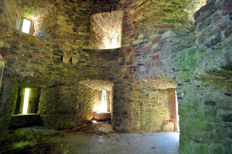
Stolzenberg Castle’s remnants reveal the layout and defensive sophistication of a medieval hilltop fortress. The most prominent surviving feature is its bergfried, a tall tower approximately 20 meters high designed to oversee and protect the castle’s most vulnerable approaches. Originally, this tower had an elevated entrance positioned about ten meters above the ground, reachable only by a removable ladder for security purposes. Today, visitors access the bergfried via a modern ground-level doorway and ascend 88 steps to reach the viewing platform, which offers expansive views of the surroundings.
In front of the bergfried stands a substantial section of wall, believed to be the foundation or the back wall of former buildings within the castle’s inner courtyard, known as the burghof. This wall fragment provides a glimpse into the castle’s internal structural arrangement, hinting at the presence of living quarters or administrative spaces adjacent to the tower.
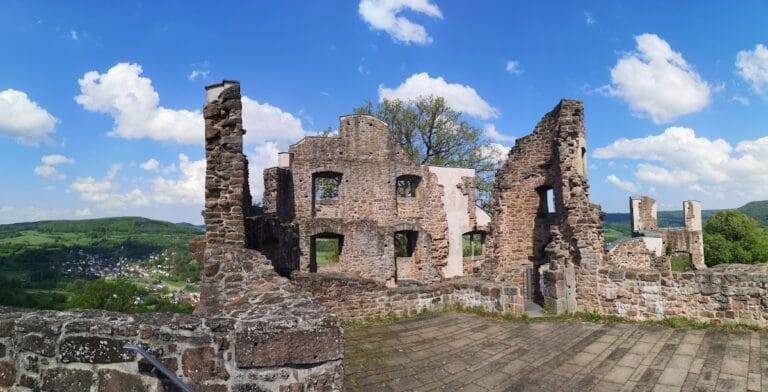
The entire hilltop once was encircled by a ring wall that enclosed the plateau and formed a formidable defensive barrier. Although only the double surrounding ditches and earthworks remain today, these features outline the castle’s original perimeter and indicate the extent of its fortifications. The deep ditches would have served as obstacles to attackers, while the earthen embankments supported wooden palisades or stone walls.
Over the centuries, stones from the fortress were frequently reused in local buildings, contributing to the ruinous state visible today. However, preservation efforts in the 20th century helped stabilize the remaining masonry and prevent further decay. The site enjoys protection as a historic monument and remains openly accessible, allowing continued appreciation of its medieval heritage and architectural legacy.
Nearby sites