Safed Fortress: A Historic Stronghold in Israel


Visitor Information
Google Rating: 4.4
Popularity: Low
Google Maps: View on Google Maps
Country: Israel
Civilization: Unclassified
Remains: Military

History
Safed Fortress is located on a hill in the center of Safed, Israel. The site’s earliest occupation dates back to the Canaanite Bronze and Iron Ages, and it likely served as a fortress during the later years of the Second Temple period. Around the time of the First Jewish–Roman War, the Jewish historian Yosef ben Matityahu, known as Josephus, fortified the stronghold to defend against Roman attacks.
During the early Muslim period, evidence points to the presence of a single tower on the site, known as “Burj al-Yatim.” In 1102, Crusader forces constructed a substantial fortress upon the remains of this earlier structure. The fortress underwent major expansion in 1140 during the reign of King Fulk of Jerusalem. Later, in 1168, control passed to the Knights Templar, who enhanced the stronghold’s defenses and held it for about two decades.
Following the Crusader defeat at the Battle of Hattin in 1187, Muslim forces laid siege to Safed Fortress and captured it in 1188. The Ayyubid dynasty governed the fortress for nearly fifty years, with a brief interruption by the Teutonic Order. Early in the 13th century, the Ayyubid emir al-Mu’azzam Isa partially dismantled the fortress to prevent it from falling back into Crusader hands.
In 1240, the Crusaders regained Safed through negotiations and rebuilt the fortress, making it one of the region’s largest Crusader strongholds. The fortress was recorded in detail in 1264 by Bishop Benoît d’Alignan, who described its imposing double walls, deep moat, and numerous defensive towers.
The Mamluk Sultan Baibars captured the fortress in 1266 after a siege lasting six weeks. He ordered the execution of most defenders and established Safed as the administrative center for the Galilee district. The Mamluks undertook extensive reconstruction, adding two large towers, including a round victory tower equipped with a sizable water cistern and a massive gate tower.
Earthquakes in 1303 and 1837 caused significant damage. The quake of 1837 devastated the fortress, leading to its abandonment and the removal of many stones by local inhabitants for other building projects. Though the Mamluks carried out restoration in 1475, the fortress lost much of its strategic significance during Ottoman rule. Only limited repairs were made in the 18th century under the local ruler Daher al-Omar.
In 1799, Napoleon’s troops briefly occupied Safed Fortress. Archaeological excavations began in 1875 and have continued intermittently since 1961, uncovering remnants from the fortress’s many historic phases. In the mid-20th century, a memorial garden was created at the site to honor local individuals who died in war.
The fortress held a key role during the 1948 Arab-Israeli War. Fierce fighting culminated in Jewish forces capturing the fortress on May 10, 1948. This military victory played a part in the subsequent departure of much of Safed’s Arab population.
Remains
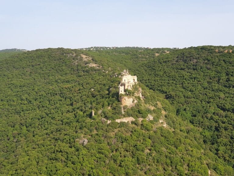
The Safed Fortress occupies roughly four hectares on a hill rising 834 meters above sea level, commanding panoramic views of the surrounding region. The Crusader fortress featured a double line of defensive walls enclosing an area approximately 252 meters long by 112 meters wide. The inner wall stretched about 580 meters in circumference, while the outer wall extended around 850 meters, both standing around 28 meters tall. Between these walls lay a deep moat up to 18 meters deep and 13 meters wide that provided a formidable obstacle to attackers. Today, the outer moat corresponds approximately to the modern path of Jerusalem Street.
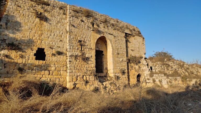
Along the outer wall, seven heavily fortified towers rose about 26 meters high, spaced to cover the fortress’s perimeter with overlapping fields of defense. The Crusaders also built numerous vaulted halls with characteristic pointed Gothic arches, representing their architectural style. A prominent high gate tower guarded the entrance, complemented by walls equipped with arrow slits and firing niches designed for defenders’ protection.
Recent archaeological work uncovered a substantial stone wall approximately 25 meters long and 2 meters wide, featuring arrow slits that allowed defenders to shoot while remaining shielded. Alongside it lies an octagonal wall section measuring 6 by 3.2 meters and delicate carved columns decorated with floral motifs. Paved passageways with drainage channels demonstrate the careful planning of medieval water and waste management inside the fortress.
The Mamluks significantly altered the fortress by adding two enormous towers. The southern round victory tower, about 60 meters tall and 35 meters in diameter, contained a large water cistern carved from the rock within its base. This cistern would have been essential for sustaining the garrison during sieges. A massive gate tower measuring 15 by 20 meters stands at the southwest corner. Both towers partially survive beneath the modern monument and garden situated at the summit of the hill.
Additional Mamluk constructions include a group of utility buildings linked by a rectangular corridor, a paved access ramp leading up to the gate tower that is 24 meters long and roughly 7 to 8 meters wide, as well as arches and archivolts displaying fine stonework. Among the large carved stones is one emblazoned with a roaring lion, which is believed to represent Sultan Baibars. The site also contains a large circular well, approximately 10.5 meters deep and 10 meters wide, alongside numerous pottery fragments of local and imported origin, and coins from the Mamluk and Venetian periods.
The fortress, having endured centuries of earthquakes—including significant tremors in 1303 and 1837—bears marks of extensive damage. After its abandonment, many stones were repurposed by locals for building materials. Archaeological excavations carried out since the late 19th century have included efforts to conserve and partially restore the ruins, with a visitor path designed to navigate the exposed remains. The layered garden that surrounds the site today respects the hill’s natural slopes and protects the fortress’s archaeological features, allowing the history embedded in its walls and towers to be studied and appreciated.
Nearby sites