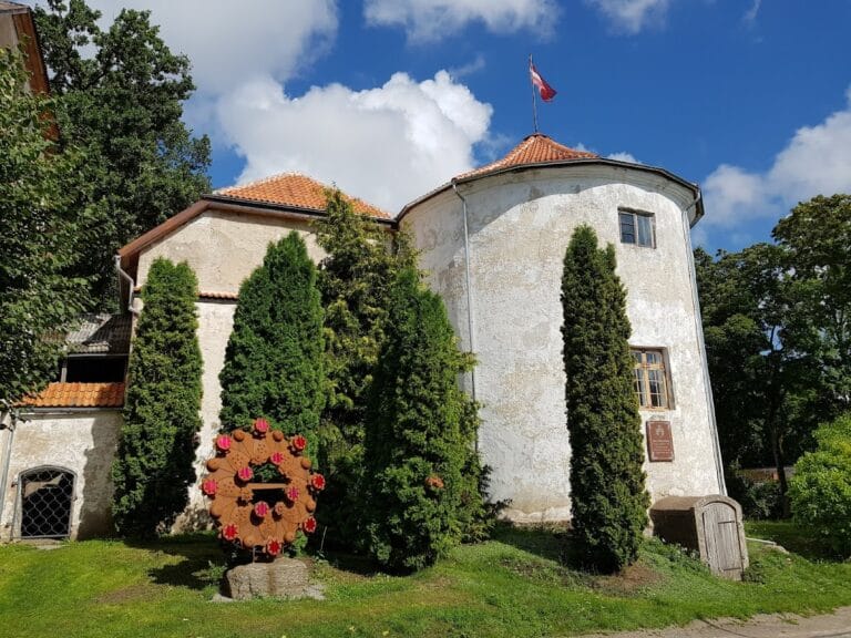
Piltene Castle: Medieval Episcopal Stronghold in Latvia


Visitor Information
Google Rating: 4.5
Popularity: Very Low
Country: Latvia
Civilization: Early Modern, Medieval European
Site type: Military
Remains: Castle
History
Piltene Castle is situated in the town of Piltene within the Ventspils municipality of modern Latvia. It was constructed by the medieval Livonian church authorities as the administrative center and residence for the Bishopric of Courland during the late 13th century.
The origins of the bishopric in this region trace back to the early 13th century, when the territory was initially granted to the Livonian Brothers of the Sword in 1230. Shortly thereafter, the area came under control of the Teutonic Order following the Swordbrothers’ integration, with the bishopric formally established around 1234 though its seat remained unsettled for several decades. The earlier episcopal residence, known as Amboten, was lost to the Teutonic Order, prompting the establishment of a new castle at Piltene, likely around 1295. This foundation corresponds with the tenure of Bishop Burchard (1300–1311), who moved the bishop’s seat to Piltene.
The castle appears in written records from 1309 amid a civil conflict that forced the bishop to flee his territories. Over the next two centuries, Piltene Castle grew in size and importance, evolving from a fortified episcopal residence into a fully developed administrative center. By the late 14th century, the surrounding settlement had been granted town rights, reflecting the castle’s role as a regional hub. Throughout this period, the castle underwent expansions and improvements to its defenses to meet changing military needs.
In 1559, facing the decline of ecclesiastical power during the turbulent Livonian War, the last bishop sold Piltene and its lands to the Danish crown. King Frederick II of Denmark then conferred the territory upon his brother, Duke Magnus of Holstein, who had been crowned King of Livonia with the approval of Tsar Ivan IV of Russia, known as Ivan the Terrible. However, the conflict engulfed the region, and in 1583, Polish forces partially destroyed Piltene Castle to prevent its use by Danish troops. That same year, Duke Magnus died within its walls.
Following decades of contest over the territory, Piltene came under the control of the Polish-Lithuanian Commonwealth in 1617. By 1621, the castle had partly collapsed, entering a period of decline. Its strategic and administrative significance waned, and over the following century the structure slipped into ruin. In 1710, a major flood altered the course of the Venta River, severing the castle from direct water access and ending its role in riverine trade. By the mid-18th century, the castle was no longer in use and had largely fallen into decay.
Archaeological investigations in the late 20th century uncovered the remains of the castle’s foundations and defensive features, enriching understanding of this medieval episcopal complex and its historical transformations.
Remains
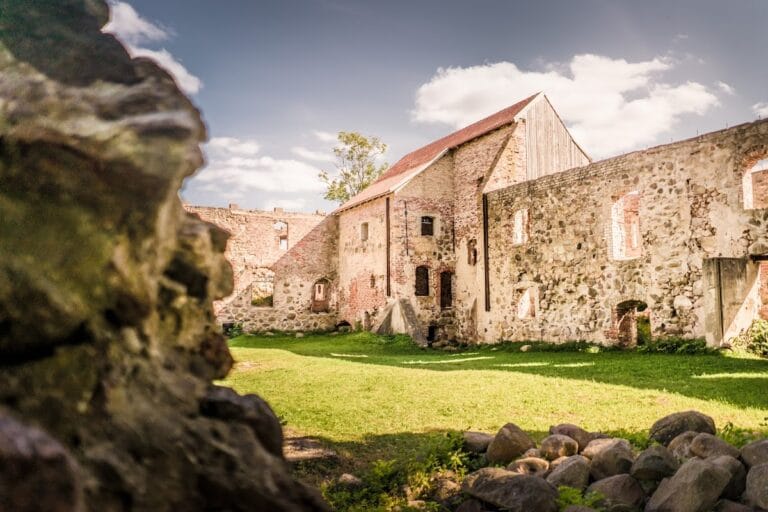
Piltene Castle was designed as a convent-type castle, a style characteristic of Central and Northern European ecclesiastical fortifications. The main building formed a roughly rectangular courtyard measuring about 40 by 50 meters, composed of three wings arranged around an inner courtyard. On the eastern side stood the castle church along with vaulted chambers beneath, while the northern wing contained the bishop’s private chambers and a large hall intended for official gatherings. The western wing housed vaulted rooms likely used for kitchen and dining purposes.
Surrounding the core castle on the east and south was a spacious outer bailey approximately 110 by 130 meters in size. This enclosure was protected by multiple square towers as well as two notable round artillery towers, built to defend against escalating military threats from the late medieval period onwards. The smaller round tower, locally known as the “Kuraditorn” or “Schmachturm,” has a diameter near 8.6 meters. Its surviving lower part—constructed from fieldstones—and the brickwork above remain up to six meters high. This tower presently stands as the tallest ruin on site, reaching about 11 meters.
The larger artillery tower, called the “großer Rondeel,” measured roughly 14.2 meters across and featured a combination of fieldstones and limestone, including ornamental masonry details. Its lower walls, which are nearly three meters thick, still survive. These towers reflect the adaptation of the castle’s defenses to accommodate artillery weaponry emerging in the 15th and 16th centuries.
The main gate to the castle lay within the southern wall of the outer bailey. This entrance was secured by two drawbridges equipped with iron chains and defended by a square gate tower rising over three floors. The top story of this tower housed two bells, likely used for signaling or ecclesiastical purposes. Nearby stood a wooden four-room building serving the castle’s personnel, along with a stable close to the gate area.
Within the convent building lies a well placed near its southern wall, opposite the main entrance, underscoring the importance of reliable water supply inside the fortress. The ground floor included vaulted halls, and rooms for storage as well as facilities such as a kitchen, brewery, and bakery, evidencing a degree of self-sufficiency. Agricultural goods were stored in chambers dedicated to grain and similar provisions.
Above this, the first floor contained a chapel complete with choir and sacristy. Decorative features included painted panels, notably a depiction of the Three Magi, brass chandeliers, an organ, and seating arranged along both sides for worshippers. A large hall with distinctive nine-part windows bore coats of arms and functioned as a refectory or dining room. The bishop’s private quarters comprised a sleeping chamber, a so-called “mirror chamber,” and an ornate hall displaying portraits of previous bishops, complete with tiled stoves and benches positioned near numerous windows. Access to upper-level storage rooms and granaries on the second floor was provided by a spiral staircase.
Constructed mainly of fieldstones, bricks, and limestone, the castle’s appearance was enhanced in the 16th century through the addition of dolomite window frames featuring decorative details. Originally, the fortress was surrounded by a water-filled moat connected to the Venta River. Changes to the river’s flow over time mean that today the castle ruins now stand approximately 1.5 to 2 kilometers from the current river channel. The southern moat survives, along with two small ponds and a marshy ditch.
Present traces consist mainly of fragments of the two round artillery towers and low walls of the main convent building. Approximately 100 meters east of the castle remains stands the Lutheran parish church of Piltene, erected around 1808. Local tradition suggests that stones from the castle ruins were repurposed in the church’s construction. Excavations by archaeologist Ēvalds Mugurēvićs in the 1970s uncovered foundations, defensive ditches, and remains of an old bridge, further illuminating the layout and extent of this medieval episcopal stronghold.
Nearby sites