Kocherburg: A Historic Castle Ruin near Aalen, Germany


Visitor Information
Google Rating: 4.6
Popularity: Very Low
Google Maps: View on Google Maps
Official Website: www.kocherburg.de
Country: Germany
Civilization: Unclassified
Remains: Military

History
Kocherburg is a castle ruin located near Unterkochen in the municipality of Aalen, Germany. The site traces its origins to the 11th century when medieval builders constructed the castle on a hilltop that had previously served as a prehistoric fortification.
During the early medieval period, the castle likely served as the residence of the Lords of Kochen, who are recorded in documents from 1136. These lords may have acted as ministeriales—unfree knights or officials—under the Counts of Dillingen or administered land for Ellwangen Abbey. By the 13th century, Kocherburg had developed into an administrative center for Ellwangen Abbey, managing the upper Kocher region.
Around 1280, the castle was forcibly taken by the Counts of Oettingen amid a dispute with the abbey. The counts placed the Ahelfinger family, their ministeriales, in charge as stewards of the property. In 1317, Kocherburg appears in a record as “Castrum Kochenburch” during a property exchange between Konrad von Ahelfingen and Ellwangen Abbey. At this time, it functioned as the seat of the abbey’s vogt, a type of bailiff or administrator.
Throughout the late Middle Ages, the castle remained associated with Ellwangen Abbey and its leadership. Notably, Abbot Albrecht Hack von Wöllstein resided there in 1397, and in 1461, Prince-Abbot Johann von Hürnheim used Kocherburg as a retirement home.
Between 1627 and 1632, Prince-Abbot Johann Jakob Blarer von Wartensee undertook major changes. Finding the medieval buildings in poor condition, he ordered their demolition and envisioned a new Renaissance-style three-winged palace designed by the architect Hans Alberthal. The narrow plateau on which the castle stands, however, prevented completion of this grand plan.
During the Thirty Years’ War, Swedish troops destroyed the newly constructed palace in 1645. Following the devastation, stones from the ruined castle were reused locally in building projects carried out in 1649 and again in 1764. The castle site was later covered by a dense beech forest through reforestation efforts begun in 1813, effectively concealing it from view.
Archaeological interest arose in the early 20th century when Konrad Albert Koch led excavations starting in 1913, uncovering masonry walls and a vaulted cellar. Further exploration took place in 1914. Renewed conservation and research efforts began in 2007 under the Initiative Ruine Kocherburg (INKO). They stabilized sections of the castle’s eastern defensive wall and conducted additional archaeological surveys, including a 2010 study that employed three-dimensional modeling to better understand the site.
In recognition of its preservation work, this initiative received the Silver Half-Sphere award from the German National Committee for Monument Protection in 2023. Today, Kocherburg is protected as an archaeological monument, preserving its layered history across nearly a millennium.
Remains
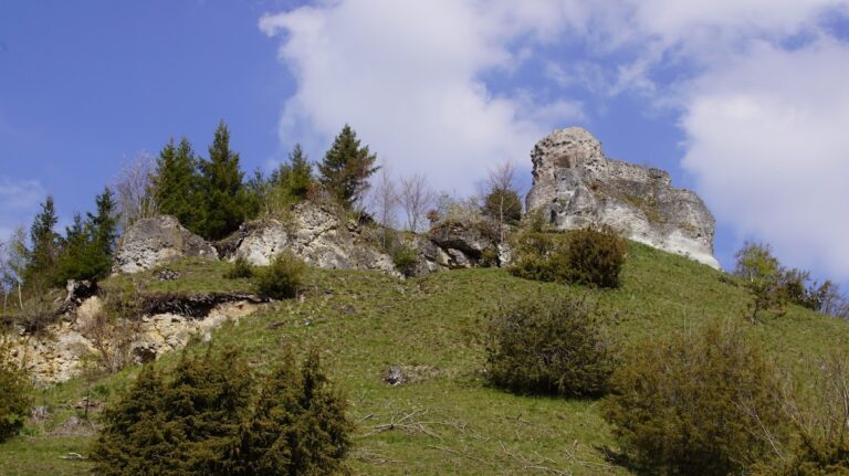
The ruins of Kocherburg occupy a narrow plateau known locally as the Schlossbaufeld, standing at about 572 meters above sea level and overlooking the Häselbach valley by roughly 80 meters. The castle evolved in three distinct stages: the original medieval fortification from the 11th century, renewed around 1200; an expansion during the 14th century when it served as the seat of the abbey’s vogt; and the partially completed Renaissance palace envisioned in the early 17th century.
Defensive features include a rock-cut ditch carved into the hillside on the eastern side, which originally protected the castle’s approach by creating a steep barrier. This feature now forms a forest path. Adjacent to this ditch, a shield wall—measuring approximately 12 meters—provided additional protection on the eastern flank. This wall, preserved to a significant height, showcases rusticated ashlar masonry. These are large stone blocks with a deliberately roughened surface, known in German as Buckelquader, which are visible along the fully preserved south wall and have been reused in sections inside the ruins.
The main castle area once comprised a complex of three to four wings arranged around a central courtyard on a plateau slightly lower, near 560 meters elevation. The western side connected to a lower-lying outer bailey, which was accessed by a path from the northwest passing a round tower and the castle’s inner gate. This gated entrance led into the courtyard and an enclosed defensive area called the zwinger, a narrow space designed to trap attackers.
Excavations have revealed several notable structural elements. A vaulted cellar, discovered in the northeast section and exposed to view in 2021, provides evidence of medieval storage or service areas beneath the surface buildings. On the south wall, an external garderobe shaft has been identified; this was a medieval latrine, constructed to allow waste to drop away from the living quarters.
Further remains include fragments of a tower on the west and a northern passageway that once connected the outer zwinger area to the inner castle. Most masonry from the site consists of locally quarried stone, carefully worked using period techniques. Conservation interventions have focused on stabilizing the eastern shield wall by injecting cement to block water from seeping into cracks and cleaning the stone surfaces through gentle sandblasting.
Advances in archaeological methods have allowed the site’s topography and architectural remains to be digitally reconstructed using three-dimensional modeling and animation. This technology aids in visualizing the castle’s appearance at various points in its history and supports ongoing preservation and interpretation efforts.
Nearby sites