Castle of Monforte: A Historic Fortress in Chaves, Portugal


Visitor Information
Google Rating: 4.2
Popularity: Low
Google Maps: View on Google Maps
Country: Portugal
Civilization: Unclassified
Remains: Military

History
The Castle of Monforte is situated in the municipality of Chaves in Portugal and was established by medieval Portuguese authorities. Its origins, however, date back to prehistoric times when the site functioned as a castro, a type of fortified settlement typical in the Iberian Peninsula.
During the Roman era, the location was reoccupied because of its strategic proximity to the Roman road that linked Astorga with Braga. Archaeological findings include two altars, one dedicated to the household gods known as Lares, underscoring the site’s connection to Roman religious practices. The castle itself appears in historical records starting in the 12th century, highlighting a noble lieutenant in charge of the fortress. The jurisdiction known as Rio Livre was formally organized in 1267, and by 1273, King Afonso III granted the town its first charter. This act likely triggered significant renovations on the castle, establishing Monforte as a key territorial seat within the northern border management system, a policy that included contemporaneous projects like the Castle of Montalegre.
Construction continued into the reign of King Denis I from 1279 to 1325 and was completed in 1312, giving the stronghold a formidable keep and walls supported by three towers. During this era, a castle governor called an alcaide is recorded, reflecting the organized military command and civil administration. The urban area around the castle grew as the town walls expanded, and King Afonso IV issued a fresh charter, reinforcing the settlement’s importance.
The period of civil conflict between 1383 and 1385 saw the castle and town initially side with Beatriz, a claimant to the throne, yet they accepted King John I during his campaign in the north. In 1420, responding to suggestions by the town’s mayor Álvaro Gonçalves de Ataíde, King John I founded a refuge at Monforte for fifty fugitives to strengthen the population and improve the settlement’s defenses. It was likely during this time that the castle’s barbican (a fortified outwork protecting the entrance) and surrounding moat were constructed, features illustrated by Duarte de Armas in his early 16th-century sketches. Addressing the ongoing needs of the town, King Manuel I granted a new charter between 1495 and 1521.
The castle underwent further modification during the Portuguese Restoration War between 1640 and 1656, when King John IV’s War Council ordered updates to modernize its defenses, adapting them for artillery warfare. Additions included a half-bastion and other fortifications east of the original medieval keep. Throughout this time, the domains of Monforte de Rio Livre were under the ownership of the Casa do Infantado, established by Infante Francisco, a son of King Peter II and brother to King John V.
By the 18th century, documentation shows the castle in a state of ruin, while the town itself was home to some 381 residents. In the early 19th century, national fortification initiatives equipped the site with four artillery pieces, demonstrating continued albeit limited military use. After the municipality of Monforte de Rio Livre was abolished in 1853, the castle and surrounding village were largely deserted. Recognizing its historical significance, the castle was designated a National Monument in 1950, leading to government efforts focused on stabilization and restoration. Renewed conservation and minor archaeological excavation were undertaken during the 1990s, ensuring the site’s preservation.
Remains
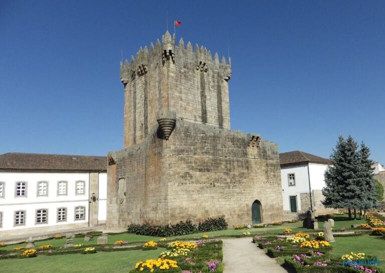
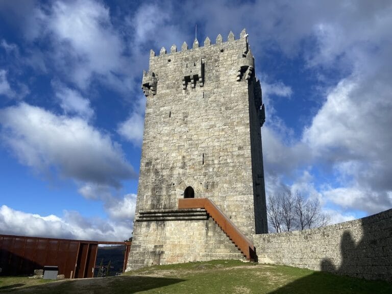
The Castle of Monforte is constructed mainly from local granite, reflecting the abundant regional stone, and its overall structure remains in relatively good condition. The castle’s layout centers around sturdy walls that once enclosed the medieval town, forming a defensible circuit with strategically placed gates. Two principal entrances lead into the castle courtyard: the Porta da Vila, located on the western side, is distinguished by a broad pointed arch and provided direct access to the medieval settlement; the southern portal, known as the Porta da Traição or “Traitor’s Gate,” features a narrower round arch, possibly designed for controlled defense. The walls are topped by a parapet or walking platform, referred to in Portuguese as an adarve, from which a door opens into the inner keep.
The keep itself presents a solid quadrangular design topped with a series of tripartite corbels—stone supports divided into three parts—that once supported defensive structures such as battlements or hoardings. Internally, the tower is arranged over three floors, each illuminated by narrow openings designed to provide light while maintaining strong defensive qualities. Entry to the keep is granted by a high doorway with a rounded arch, located on the middle floor, which suggests controlled access for security purposes. The lowest level houses a vaulted cistern used for water storage, essential during sieges or times of isolation.
From the original medieval town enclosure, which formerly included three gates, the sole surviving one is the Porta do Galeão. This remaining gate adds to the sense of the fortified settlement’s scale and its defensive planning. Illustrated plans from the 18th century show the castle in a partially ruined state, and later interventions have sought to conserve its surviving structures while respecting its historical layout.
Together, these archaeological and architectural remains offer direct insight into the castle’s evolution from an early defensive stronghold to a fortified medieval town center, reflecting adaptations to changing military technologies and administrative needs across centuries.
Nearby sites