Caer Gybi: A Roman Fortlet and Early Christian Site in Holyhead, Wales


Visitor Information
Google Rating: 4.4
Popularity: Very Low
Google Maps: View on Google Maps
Official Website: cadw.gov.wales
Country: United Kingdom
Civilization: Unclassified
Remains: Military
History
Caer Gybi is a Roman fortlet located in Holyhead, a town on Holy Island, within the modern country of Wales, United Kingdom. It was established by the Romans around the late 3rd or early 4th century AD as part of their military infrastructure in Britannia Superior.
The site was likely constructed to serve as a smaller defensive outpost alongside Segontium, a larger Roman fort near Caernarfon. Its primary purpose was to protect the western coastline of Roman Britain from seaborne raids, particularly those conducted by groups from across the Irish Sea. This role placed Caer Gybi within a regional network of coastal defenses, which included a watchtower situated on Holyhead Mountain, believed to function as a lookout point to warn the fort of incoming threats.
Around 393 AD, the fort is thought to have been abandoned when Roman troops were redirected to confront the rebellion led by Eugenius of Gaul. After the end of Roman control, the site entered a new phase in the 6th century when King Maelgwn Gwynedd granted the location to Saint Cybi. Saint Cybi founded a monastery here, and the area became an early Christian religious center. The Church of St Cybi, along with a small separate chapel known as Eglwys y Bedd, reputed to mark the saint’s grave, stand on the site, preserving its spiritual heritage.
In the 10th century, the monastic church within the fort’s walls suffered a Viking raid, resulting in its looting. Subsequently, during the 13th century, a new church was erected just outside the perimeter of the original fortifications, marking a shift in the site’s ecclesiastical layout. Throughout its history, Caer Gybi remained connected to Segontium by a Roman road, underscoring its integration into the wider Roman military network.
Remains
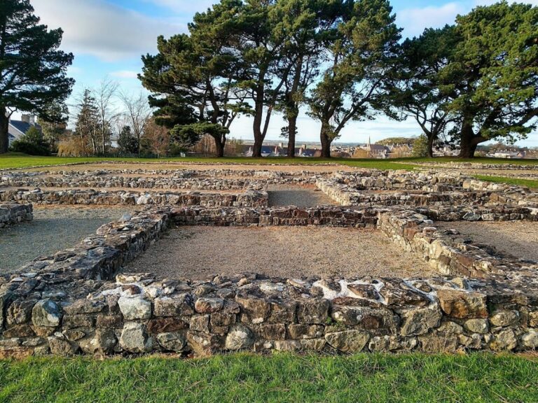
Caer Gybi is distinguished by its unique defensive arrangement, with stone walls enclosing three sides of the fort while leaving the fourth side open toward the sea. This open side likely functioned as a quay, allowing Roman naval vessels direct access to the fort. The defensive walls are built using a herringbone masonry technique, characterized by stones laid diagonally in alternating directions, which provided structural strength and a distinctive appearance. These walls stand approximately four metres high and measure around 1.5 metres in thickness.
Each corner of the three enclosed sides originally featured a circular watchtower designed for observation and defense. The north-east tower is the most complete example surviving today, rising to a height of 7.9 metres. Its upper parts may have undergone restoration or reconstruction during the Medieval period, reflecting continued use or preservation efforts beyond the Roman era.
Excavations near the north-west corner outside the northern wall uncovered an adjoining building sharing construction styles consistent with Roman methods. This suggests the fort’s footprint extended beyond the walls, possibly serving ancillary or support purposes. The entire site is situated centrally within modern Holyhead, resting roughly 12 metres above sea level on Holy Island, positioning it strategically for both military defense and maritime activity.
Together, these features showcase Caer Gybi’s role as a coastal fortification and naval base, with its defensive walls, watchtowers, and seaward quay illustrating its designed function within the Roman coastal defense system. The survival of these structures, alongside later ecclesiastical buildings, offers insight into the site’s long history from its Roman beginnings through its early Christian significance.
Nearby sites