Burg Camburg: A Medieval Hill Castle Ruin in Germany


Visitor Information
Google Rating: 4.4
Popularity: Very Low
Google Maps: View on Google Maps
Official Website: dornburg-camburg.de
Country: Germany
Civilization: Unclassified
Remains: Military
History
Burg Camburg is a hill castle ruin situated in the municipality of Dornburg-Camburg in modern-day Germany. It was constructed by medieval German nobility during the second half of the 11th century, with ties to early regional rulers.
The earliest documented connection comes from a Count Wilhelm of Camburg mentioned in 1088, though it is uncertain if he directly owned the castle at that time. By the mid-12th century, the castle was clearly associated with the Wettin dynasty, a prominent ruling family in the region. The first specific reference to a margravial fortress at Camburg dates from 1166. Positioned strategically above the Saale River, the castle controlled an important crossing along the medieval salt trade route known as the Salzstraße.
Over the 12th and 13th centuries, Burg Camburg came under the influence of local noble families, including ministeriales—unfree knights serving the Wettins—and may have connections to the Reginbodonen lineage. The presence of a castle chapel is recorded from 1213, indicating a religious function within the complex.
The castle faced military challenges during regional power struggles. In 1191, it endured a siege by Landgrave Hermann I of Thuringia. Nearly a century later, Count Günther of Kevernburg attempted another siege in 1280 but was unsuccessful. The castle’s decline culminated in the mid-15th century during the Saxon Brother War, when Elector Frederick II of Saxony ordered its destruction, sparing only the main tower known as the bergfried.
Following its devastation, the castle was not rebuilt but remained under Wettin control. Ownership passed through various branches of the Ernestine duchies, reflecting shifting political boundaries. In the late 1800s and early 1900s, a guesthouse was erected on the ruins, but this was removed in 1935 when the lower castle area was repurposed as a “Jugendburg,” or youth castle, serving Nazi youth organizations. Since 2006, efforts have restored the remaining bergfried, which now functions as a museum and observation point. Additionally, a building on the site serves a civil registry role today.
Remains
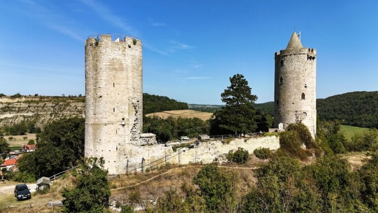
Burg Camburg occupies a narrow spur extending about 285 meters north to south, with widths ranging from 25 to 75 meters at an elevation of 179 meters above sea level. This elongated hill is naturally defensible and was artificially divided by a deep and broad neck ditch that today is crossed by the B 88 highway, separating the site into two main parts: the upper and lower castles.
The lower castle, often referred to as the Turmberg, is roughly four-sided and dominated by the bergfried, a tall main tower approximately 37 meters high with an external diameter of 11 meters. This tower dates from the late 12th or early 13th century and stands largely intact. Surrounding the bergfried are remnants of a curved curtain wall made from stone, portions of which still extend from the tower, outlining parts of the original fortifications.
Above, on the southern end of the spur, lies the upper castle known as the Matzberg. This area is defined by a large earthen rampart measuring roughly 45 meters long, 25 meters wide, and rising 15 meters high. This substantial earthwork served as a barrier, blocking access to the spur’s southern approach and thereby fortifying the site naturally and artificially. The upper castle sits several meters higher than the lower part, emphasizing the castle’s layered defenses.
Excavations carried out in 1935 in the lower castle’s vicinity uncovered sections of outer walls and the foundations of what was likely a major residential or representative building situated to the south of the bergfried. Among these were cellar remains shaped in a trapezoid about 5 by 6 meters in size. Evidence of destruction by fire was found in the debris, confirming the castle’s violent end in the mid-15th century.
A range of artifacts was discovered within this archaeological layer. Ceramics, primarily gray or blue-gray earthenware from the 13th to 15th centuries, were found alongside 14th-century stoneware pieces such as a distinctive Jacobakanne — a type of jug — originating from Waldenburg. Unique ceramic fragments included parts shaped as a horse’s head and torso of a rider that once formed an aquamanile, a vessel designed for ritual hand washing, and also a lion-head mask.
Glass finds feature a ribbed cup dating to the mid-15th century. Coins included a Prague groschen and a container lid for Meissen groschen, medieval silver coins used in the region. Metal objects uncovered comprise copper fittings inscribed with letters, various strap fasteners, a gilded wire, a bone comb with eight teeth, as well as weapon fragments such as crossbow nuts, bolt tips, and a spur estimated to date broadly from the 10th or 11th century.
While the stratigraphic context—the layering of archaeological deposits—is limited, these objects confirm that the castle was established no earlier than the late 11th century and underwent destruction consistent with historical records of the 1450 Saxon Brother War.
No formal excavations have been conducted on the upper castle terrain. Some finds reported from early 20th-century landscaping works include a lance tip and six crossbow bolts, but as these objects are lost, their documentation survives only through drawings.
Today, the best-preserved structure on the site is the bergfried, standing prominently and restored to house a museum and observation platform. Portions of the surrounding curtain wall remain visible as stone ruins, while much of the rest has been reduced to earthworks. The site has also been adapted for modern uses, including event spaces and municipal functions, integrating the historical landscape with contemporary community roles.
Nearby sites