Archaeological Park Magdalensberg: A Celtic and Roman Settlement in Carinthia, Austria
Table of Contents


Visitor Information
Google Rating: 4.7
Popularity: Low
Google Maps: View on Google Maps
Official Website: landesmuseum.ktn.gv.at
Country: Austria
Civilization: Celtic, Roman
Remains: City

Context
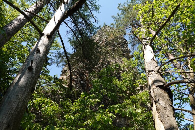
The Archaeological Park Magdalensberg is located on a prominent hill near the modern town of Magdalensberg in Carinthia, southern Austria. Positioned on an elevated plateau overlooking the Klagenfurt Basin, the site commands extensive views of the surrounding Alpine landscape. This strategic location provided natural defensive advantages and enabled control over key transit routes linking the Eastern Alps with the Adriatic Sea, facilitating trade and communication across the region. The local environment comprises mixed forests and fertile soils, which supported both settlement and agricultural activities during antiquity.
Initial occupation at Magdalensberg dates to the late Iron Age, around the 3rd to 1st centuries BCE, when the Celtic Noric kingdom established a settlement here. The site later evolved under Roman influence following Noricum’s peaceful incorporation into the Roman Empire in the early 1st century CE. Archaeological evidence attests to continuous habitation through the early Imperial period, with urban development reflecting a blend of Celtic and Roman cultural elements. The settlement was abandoned by the mid-1st century CE, with the summit sanctuary remaining in use until late antiquity. Excavations beginning in the 19th century have revealed well-preserved urban structures, fortifications, and artifacts, benefiting from the site’s elevated position and limited modern disturbance. Today, the park functions as an open-air museum preserving this complex archaeological landscape.
History
Late Iron Age and Celtic Noric Settlement (3rd century BCE – mid 1st century BCE)
Magdalensberg originated as a Celtic Noric settlement during the late Iron Age, within the Noric kingdom that controlled the Eastern Alpine region. The area’s abundant and high-quality iron ore deposits, known as Ferrum Noricum, underpinned a thriving metallurgical economy and extensive trade networks extending into the Mediterranean. In 170 BCE, the Noricans formalized diplomatic and economic relations with Rome through a hospitality treaty (hospitium publicum), facilitating increased cultural and commercial exchange. By the mid 1st century BCE, Magdalensberg had developed into a significant market center, likely influenced by the proximity of the Noric royal residence and a prominent sanctuary on the summit plateau.
Archaeological investigations have uncovered late Celtic fortifications on the northern slope, including ramparts dated between 40 and 30 BCE, exhibiting construction techniques comparable to the Fécamp-type fortifications known from late Celtic France. Early Roman merchants established a trading emporium at Magdalensberg, evidenced by iron smelting installations and simple residential structures. The consecration of the Youth of Magdalensberg statue by two merchants during this period attests to the site’s commercial importance. Trade intensified in the mid 1st century BCE, driven by Roman military campaigns and civil wars, increasing demand for Noric iron and other goods. The construction of a forum complex on the southern slope, surrounded by tabernas serving as warehouses, offices, and residences, reflects early urban development influenced by Italian architectural models. Merchant buildings from this era display mortar masonry, plastered walls, and frescoes in Pompeian second and third styles, indicating cultural assimilation and prosperity.
Roman Incorporation and Urban Development (16/15 BCE – mid 1st century CE)
Following the peaceful annexation of Noricum into the Roman Empire around 16/15 BCE, Magdalensberg’s status was elevated as the political and economic center of the eastern Alpine region. The settlement underwent extensive urban transformation, including the expansion of the forum complex with Italianate features such as tabernas, a basilica functioning as a bathhouse, and a market basilica. The summit plateau hosted a fortified sanctuary complex, likely commissioned by the Noric king with Roman architectural expertise, symbolizing the fusion of Celtic and Roman identities. An undocumented earthquake between 10 and 20 CE may have caused damage, prompting reconstruction efforts including the erection of a podium temple under Emperor Tiberius.
The forum area was reconfigured with the construction of the Praetorium, an administrative basilica serving legal and political functions. Residential quarters expanded with large two-story houses featuring hypocaust heating and fresco decoration. Workshops specializing in non-ferrous metal processing, particularly brass, flourished east of the forum, while an imperial gold smelting facility was established under Emperor Caligula, processing gold from the nearby Gastein Tauern region. The city covered approximately 3 square kilometers and supported an estimated population of 3,000 to 5,000 inhabitants, reflecting its regional prominence within the Roman provincial system.
Abandonment and Succession by Virunum (mid 1st century CE)
Archaeological evidence indicates a rapid and largely unexplained abandonment of Magdalensberg before the mid 1st century CE. Urban activity ceased abruptly, with most civic and residential functions ending, though the summit sanctuary continued in use until late antiquity. The political and administrative roles of Magdalensberg were transferred to the newly founded municipium Claudium Virunum, established in the late 40s CE in the nearby Zollfeld plain. Virunum was a planned Roman municipal center designed to replace Magdalensberg’s regional functions, reflecting imperial strategies of urban reorganization and consolidation.
The abandonment left several structures, including the temple, unfinished. The precise ancient name of Magdalensberg remains uncertain; some scholars propose it was Noreia, though this is disputed due to lack of early finds, while others suggest it bore the name Virunum, supported by inscription fragments and foundation legends. The causes of decline remain debated, with hypotheses including economic shifts favoring Virunum’s more accessible location, administrative centralization, or natural disasters such as earthquakes.
Summit Sanctuary and Late Use (mid 1st century BCE – Late Antiquity)
The hilltop sanctuary complex, originally constructed in the late Celtic period and later Romanized, remained a focal point of religious activity well beyond the city’s abandonment. Enclosed by monumental fortifications comprising multiple concentric walls and elaborate gates with marble facades and a glacis, the sanctuary exemplifies a blend of Celtic and Roman architectural traditions. Excavations have revealed ritual pits and a hexastyle podium temple platform clad in Kraig marble, likely dedicated to imperial cult deities such as Divus Augustus and Dea Roma. The sanctuary’s continuous use into late antiquity contrasts with the decline of the urban settlement, indicating its enduring religious and possibly political significance.
The complex may have functioned as a princely seat during the Noric kingdom and later as a regional cult center under Roman rule. Associated finds include votive sculptures, offering vessels, and the original placement of the Youth of Magdalensberg statue. The sanctuary’s persistence underscores the integration of Celtic and Roman spiritual practices in the region’s cultural landscape.
Archaeological Rediscovery and Modern Research (19th century – Present)
After centuries of obscurity following its abandonment, Magdalensberg reentered scholarly awareness with the discovery of the Youth of Magdalensberg statue in 1502. Systematic archaeological excavations commenced in the mid-19th century, with annual campaigns since 1948 uncovering extensive urban remains including the forum, administrative buildings, residential quarters, workshops, and fortifications. The site’s elevated position and limited modern development have preserved its archaeological integrity, allowing detailed study of its complex stratigraphy and architectural phases.
Today, the Archaeological Park Magdalensberg operates as an open-air museum under the auspices of the State Museum of Carinthia. The park presents well-preserved ruins and interpretive displays that illuminate the site’s multifaceted history from its Celtic origins through Roman urbanization and eventual decline. Ongoing research continues to refine understanding of Magdalensberg’s role in regional trade, cultural integration, and provincial administration.
Daily Life and Importance by Period
Late Iron Age and Celtic Noric Settlement (3rd century BCE – mid 1st century BCE)
The earliest inhabitants of Magdalensberg were Celtic Noric peoples who settled the site primarily due to its proximity to rich iron ore deposits known as Ferrum Noricum. The population was predominantly Celtic, with social organization likely centered on tribal elites, artisans, and merchants. While direct evidence of social roles is limited, it is probable that male warriors and smiths held prominent positions, with women managing domestic crafts and households. The settlement functioned as a regional trade center, facilitating exchange between Noric iron producers and Mediterranean markets, especially following the hospitium treaty with Rome in 170 BCE.
Economic activities focused on iron extraction and smelting, with workshops producing weapons and tools for local use and export. Archaeological remains of defensive ramparts and a summit sanctuary indicate a community invested in protection and religious observance, possibly under the leadership of a Noric king or elite class. Dietary evidence suggests consumption of locally grown cereals, domesticated and wild animal products, supplemented by imported Mediterranean foods such as olives and wine, as indicated by imported vessels and fresco motifs. Clothing likely consisted of woolen tunics and cloaks typical of Celtic dress, while domestic architecture featured timber-framed houses with plastered walls. Trade was conducted in a market emporium with tabernae serving as shops and warehouses, exchanging iron bars, brass items, and imported luxury goods. Transport relied on Alpine footpaths and pack animals connecting the Eastern Alps with the Adriatic. Religious life centered on the hilltop sanctuary, where ritual pits and votive offerings attest to Celtic cult practices later incorporating Roman elements.
Roman Incorporation and Urban Development (16/15 BCE – mid 1st century CE)
Following Noricum’s peaceful integration into the Roman Empire, Magdalensberg evolved from a tribal market settlement into a Romanized urban center and regional capital. The population became culturally diverse, including Roman settlers, local Noric elites, merchants, artisans, and administrative officials. Epigraphic evidence attests to civic magistrates and legal assemblies, indicating formal municipal governance. Social stratification included affluent merchant families residing in large two-story houses adorned with elaborate frescoes and equipped with hypocaust heating, alongside craftsmen and laborers inhabiting workshop districts.
Economic life diversified with specialized workshops producing non-ferrous metal goods, particularly brass, and an imperial gold smelting facility processing precious metals from the Alpine region. Agriculture supported the urban population, supplemented by imported Mediterranean staples such as wine, olive oil, and garum, consumed in bronze and glass vessels. Archaeological evidence of richly decorated interiors—including Pompeian-style frescoes, mosaic floors, and plastered walls—reflects affluent domestic environments. Clothing likely combined Roman tunics and cloaks with local styles. Public amenities such as baths and bakeries served communal needs. The forum complex functioned as the civic heart, hosting markets, administrative offices (Praetorium), and religious buildings including an early imperial cult temple dedicated to Divus Augustus and Dea Roma. The presence of a council chamber and tribunal indicates active political life, with legal and social assemblies shaping regional governance. Transport infrastructure included paved roads and a double gate controlling access, facilitating commerce with Italy and beyond. Religious practices blended Roman imperial cult with enduring Celtic traditions at the summit sanctuary, underscoring the site’s dual cultural identity. Magdalensberg’s status as a municipium and economic hub anchored Roman authority in the eastern Alpine provinces.
Abandonment and Succession by Virunum (mid 1st century CE)
Magdalensberg’s urban life ceased abruptly before the mid 1st century CE, with most civic and residential activities ending except for continued ritual use of the summit sanctuary. The population likely relocated to the newly founded municipium Claudium Virunum in the nearby Zollfeld plain, a planned Roman town designed to replace Magdalensberg’s administrative and economic functions. This transition reflects a strategic reorganization of regional governance and trade networks under imperial policy.
Daily life at Magdalensberg declined rapidly, leaving unfinished buildings and abandoned workshops. The reasons remain debated but may include economic shifts favoring Virunum’s more accessible location, administrative centralization, or natural disasters such as earthquakes. The sanctuary’s persistence suggests religious continuity despite urban decline. In Virunum, civic structures, markets, and residential quarters developed to accommodate the transferred population and functions, illustrating the Roman tendency to establish new urban centers to optimize control and integration of provincial territories.
Summit Sanctuary and Late Use (mid 1st century BCE – Late Antiquity)
Throughout Magdalensberg’s urban decline, the hilltop sanctuary remained a focal point of religious and cultural life well into late antiquity. The sanctuary complex, originally Celtic and later Romanized, served as a regional cult center dedicated to imperial deities such as Divus Augustus and Dea Roma, reflecting the imperial cult’s role in provincial identity. The sanctuary’s monumental fortifications, marble-clad podium temple, and ritual pits indicate ongoing elite patronage and organized religious ceremonies.
Religious personnel likely included priests or cult officials maintaining the site, while pilgrims and local inhabitants participated in festivals and offerings. The sanctuary may have functioned as a princely seat in the Noric period, evolving into a symbolic locus of Roman authority and local tradition. While the surrounding settlement was abandoned, the sanctuary’s enduring use underscores the importance of religious continuity and the integration of Celtic and Roman spiritual practices in the region’s cultural landscape.
Archaeological Rediscovery and Modern Research (19th century – Present)
Though not a period of ancient daily life, the modern rediscovery and excavation of Magdalensberg have revealed extensive insights into the site’s historical occupation and social dynamics. Systematic archaeological work since the 19th century has uncovered urban layouts, domestic architecture, workshops, and civic buildings, allowing reconstruction of daily routines, economic activities, and cultural life. The preservation of frescoes, inscriptions, and artifacts has illuminated the complex interplay of Celtic traditions and Roman urbanism.
Research continues to refine understanding of Magdalensberg’s role as a regional center, its economic specialization in iron and metalworking, and its religious significance. The site’s open-air museum status facilitates public engagement with its layered history, while scholarly publications contribute to broader knowledge of Roman provincial life in the Eastern Alps.
Remains
Architectural Features
The Archaeological Park Magdalensberg preserves a settlement characterized by a complex urban layout developed primarily between the late 1st century BCE and the mid-1st century CE. The site occupies an elevated plateau with a southern slope where the main urban center was established. Construction techniques predominantly involve opus incertum, a Roman concrete method featuring irregular rubble stone facing with a core of concrete mixed with local rock fragments, slag, and charcoal residues. Stones were chiefly quarried from nearby Ordovician tuffs and basalts. The settlement’s architecture comprises civic, religious, residential, and economic buildings arranged on terraces adapted to the hillside topography. The city expanded notably after Noricum’s incorporation into the Roman Empire around 16/15 BCE, with urban features including a forum, administrative buildings, workshops, and a fortified sanctuary on the summit. The site was largely abandoned by the mid-1st century CE, with most structures left unused except for the summit sanctuary, which remained active until late antiquity.
Visible remains include foundations, substructures, and partial walls of various buildings, some stabilized or partially reconstructed. The settlement’s layout reflects a combination of civic and religious functions, with residential quarters and workshops integrated into the urban fabric. The elevated position and limited modern disturbance have preserved stratigraphic sequences and architectural elements, enabling detailed study of construction phases from the late Iron Age through early Imperial Roman times.
Key Buildings and Structures
Celtic Sanctuary and Fortification on the Summit Plateau
The summit sanctuary complex, dating from after the mid-1st century BCE and remaining in use until late antiquity, is enclosed by monumental fortifications comprising a double ring wall with outer walls up to 2.1 meters thick at the base. Between these walls lies a running ditch approximately 3 meters wide. Inside the double ring is a third wall ring with an additional gate. The main access road features a double gate system, including a 30-meter-long hose gate and a box gate, flanked by substantial bastions. A glacis measuring about 90 meters long and 30 meters wide lies before the gate. The gates may have been adorned with marble facades. This fortress was constructed by Roman military architects before 20 BCE and was demolished during the late Augustan to Tiberian period, possibly following the Roman occupation in 15 BCE or due to an earthquake.
West of the church on the summit, excavations uncovered a structure with a clay or rock floor elevated by 50 centimeters, covered with yellow mortar. It contains holes for wooden logs and two deep pits (1.5 meters), carefully buried and sealed with marble slabs. This may represent a roofed building with ritual pits, comparable to late Celtic sanctuaries in northern Gaul. Emergency excavations in 2006 revealed the remains of a hexastyle podium temple near the church. The temple platform measures approximately 25.5 by 16.5 meters, raised about 2 meters above the natural rock, with a podium clad in Kraig marble and a slate slab floor. The temple is about 85 Roman feet long, 55 feet wide, and 7 feet high, accessible by an open stairway on the western side. Associated finds include a clay votive sculpture, fragments of a robed statue, roof tiles, antefixes, and cornice pieces. The famous Youth of Magdalensberg statue was likely originally placed here. Only wall foundations survive, and the complex may have served as a princely seat, though this remains uncertain.
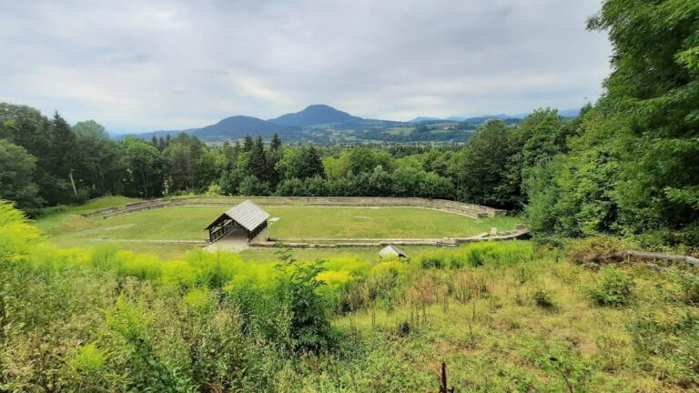
Forum
The forum is situated on the southern slope approximately 200 meters below the summit, occupying a slight depression measuring 110 by 42 meters. Its construction required significant leveling, including rock removal on the slope and earth filling on the southern side. The southern long side is traversed by the path leading to the summit. Two main construction phases are evident. The earlier Republican phase, dating to the late Iron Age under the Noric kingdom, featured a merchant basilica (market basilica) on the eastern side measuring 30 by 17 meters. Surrounding sides contained merchant tabernas initially built in wood and later replaced by stone houses with cellars. The western side housed the basilica known as the House of Representation.
In the Imperial Roman phase, post-15 BCE, the merchant basilica was demolished, and its function transferred to the newly constructed Praetorium on the northwestern side. A temple was erected on the northern side, replacing earlier taverns. The former taverns were rebuilt as stores and workshops with large wing gates to facilitate goods transport. The forum area thus reflects a transition from a primarily commercial center to a more complex civic and administrative space.
Temple District
The temple district is located centrally on the northern side of the forum, about 2 meters higher on the mountainside, covering an area of 54.6 by 45.3 meters. The final architectural phase includes a large podium temple constructed in the 1st century CE, measuring 30 meters long and 17.6 meters wide. The cella (inner chamber) measures 21 by 11 meters and was likely surrounded by either six or eleven columns. Each long side of the temple complex includes a spacious courtyard and a hall. Only the substructure remains, including two cellar rooms (favissae) accessible by a staircase on the mountain side. These cellar rooms served as storage for public funds.
An earlier, smaller temple preceded this structure. Both temples were dedicated to Divus Augustus and Dea Roma, representing the earliest known emperor cult in present-day Austria. Construction of the second temple began during Emperor Claudius’s reign but remained unfinished, lacking features such as the stairway connecting to the forum. The temple lacks marble cladding, likely removed for reuse in the nearby municipium Virunum. Beneath the temple district on the forum side, remains of mid-1st century BCE tavern buildings have been found. Behind the temple lies a rock sanctuary with an open niche, a fire pit, an altar stand, and a shaft containing vessel shards and animal bones from pets, poultry, bears, and wild boars. Three mountain pits were discovered within the temple district, one containing a deliberately cut human skull.
Praetorium
The Praetorium, located west of the temple district on the forum’s north side, is a basilica-like administrative building constructed in the early 1st century CE. Room M, the main hall, measures approximately 100 Roman feet (29.6 meters) in length and is surrounded on three sides (north, south, and east) by covered halls providing protection from weather. To the west of Room M, a double staircase leads to a deliberation room and a raised platform (tribunal or suggestus) where Roman officials conducted legal proceedings, announced decrees, and held assemblies.
The council chamber (Room K) within the Praetorium features wall paintings dating to the Tiberian period, consisting of rectangular colored fields. The building’s interpretation as a Praetorium is debated; some scholars consider it a basilica, tabularium (record office), and assembly hall complex. An official building possibly related to this complex lies on a less-explored plateau northwest of the forum.
House of Representatives (Representation House)
Situated on the western side of the forum, the House of Representatives is a north-south aligned complex divided into three sections. The northern section is a three-story block with small rooms labeled L, V, W, and K. The central section (A–E, I, J) is known as the Representation House, and two halls (F, G) were later additions. The central block includes an entrance corridor, an anteroom, a niche room, and an apse hall (Room A).
Initially, during the presence of Roman merchants, Room A with its apse formed part of a 12-meter-long basilica, likely serving as an office for market administrators. Around 15 BCE, the basilica was converted into a three-room building with an entrance corridor. Underfloor heating (hypocaust) was installed in Room A, and a water basin was constructed in the apse, probably for bathing; a bathtub likely stood on the north side. After a fire in 15 CE, the room layout remained unchanged, but the floor in Room A was raised about one meter, and the water basin was covered. The building was then likely used as a meeting hall for Roman representatives and Noric emissaries. Room B, containing thirteen wall niches, functioned as an archive.
Residential and Workshop District (NG Buildings)
East of the Merchant’s Forum along the hillside lies a residential and workshop district known as the NG buildings. This area includes large workshops specializing in non-ferrous metal processing, mainly brass. Smelting furnaces and production facilities for cauldrons, buckets, bottles, pots, and brooches in native design have been excavated. Houses are arranged on several terraces, with the lowest terrace containing residential buildings.
House NG/33 is well preserved, featuring multiple rooms including a bedroom with a terrazzo floor and a living room with a niche stove. Walls are constructed using half-timbering (opus craticium) with mortar-covered wickerwork. At the highest point on the edge of a hollow along the ancient eastern road stands a double gate built in the Tiberian period (after 14 CE) during a city center redesign. Since settlement continues east of this gate, it is not a city gate but likely a representative building.
AA Buildings
The AA buildings lie below the road that cuts through the excavation site, which also served as an ancient roadway. This complex includes a large building with a six-room bathing area, a large bakery, a kitchen, and a courtyard measuring 19 by 24 meters with a peristyle (columned walkway). Constructed in Tiberian-Claudian times on older tavern-like predecessors, the AA buildings extend eastward across three terraces. Some structures are two-story elongated buildings with ridge heights up to 15 meters.
Under Emperor Caligula, an imperial gold smelting facility was established here. Excavations uncovered two gold ingot molds and rock crystals weighing approximately 50 kilograms. Two rooms, enclosed by walls up to 13 meters high and accessible only by wooden stairs, contained remains of nineteen gold smelting furnaces. The gold processed originated from the Gastein Tauern region. Adjacent to the smelting rooms is a storage hall (AA/44) with a vaulted chamber (Thesauros, AA/45). The inscription style on the molds indicates the gold was imperial property.
Large Bathhouse Southwest of Forum
A large bathhouse was constructed on a terrace southwest of the forum during the early 1st century CE. This bathhouse replaced an earlier facility located within the forum, which was converted into a representative building. The bathhouse includes multiple rooms arranged to accommodate bathing functions, though detailed internal features are fragmentary.
Large Residential Buildings on Eastern Southern Slope
Several large two-story residential buildings were built on the eastern southern slope during the early 1st century CE. These houses feature living spaces up to 150 square meters. Upper floors were primarily wooden and partly used as warehouses or shops. The buildings are arranged on terraces conforming to the hillside’s topography.
Double Gate on Eastern Edge of Hill Hollow
A double gate constructed in the Tiberian period (after 14 CE) stands at the highest point on the edge of a hollow along the ancient eastern road. Since the settlement extends beyond this gate, it is not a city gate but likely served a representative or ceremonial function. The gate is part of the city center redesign during the early Imperial period.
Construction Techniques and Materials
Most walls at Magdalensberg were built using opus incertum, consisting of irregular rubble stone outer layers with a concrete core mixed with rock fragments, slag, and charcoal residues. Stones were predominantly sourced locally from the site and quarries on the mountain’s north side, mainly Ordovician tuffs, tuffites, and basalts, accounting for about 95% of the material. A water basin measuring 6 by 10 meters below the bathhouse was constructed using opus caementicium (cast masonry concrete).
Room A of the Representation House features a concrete floor reinforced with iron bars made of Ferrum Noricum, dating to around 15 CE. This represents the earliest known use of steel reinforcement in concrete floors. Tombstones and official buildings were originally adorned with marble, though little cladding remains, likely removed for reuse in Virunum. Early grave stelae used lower-quality marble from nearby sources, while later marble was quarried from locations up to 50 kilometers away. Fired roof tiles are scarce, suggesting houses may have been roofed with wooden shingles or that tiles were reused elsewhere.
Mural Paintings
Wall paintings at Magdalensberg span approximately 80 years, from the late Caesarian to the late Tiberian periods. No murals from the last Claudian phase survive due to incomplete construction. The fresco styles correspond to Pompeian classifications, indicating high artistic quality and strong Italic South stylistic influence.
The second style (simple) is found in underground room OR/23, depicting divine figures such as Athena with shield and Aphrodite with Eros. The Aphrodite fresco is a Greek work dating shortly after the mid-1st century BCE. The mature third style (Tiberian period) appears in Room K, featuring ten colored fields, a black base strip, and painted friezes with dolphins, golden shells, bull skulls, and sound basins.
Frescoes from rubble in room AA/15 (the Iphigenia complex) are attributed to a master painter from the Hellenized southeast Mediterranean, skilled in Greek painting and poetry. Scenes include Hades with Theseus and Peirithoos before Persephone; a shepherd scene with a youth playing a flute and a mountain god judging a competition; Dionysus with two dancing girls (Cassandra and Ino); and Iphigenia holding a greenish idol, likely a statue of Artemis.
Other Remains
Remains of tavern buildings dating to the mid-1st century BCE have been found beneath the temple district on the forum side. A rock sanctuary behind the temple includes an open niche, a fire pit, an altar stand, and a shaft containing vessel shards and animal bones from pets, poultry, bears, and wild boars. Above-ground remains of the Celtic sanctuary and fortification on the summit are limited to some wall remnants of the double gate.
Archaeological Discoveries
Excavations at Magdalensberg have yielded a variety of artifacts spanning from the late Iron Age through the early Roman Imperial period. These include architectural fragments, frescoes, inscriptions, and numerous objects related to daily life, trade, and religious practice. Notable finds include gold ingot molds and smelting furnace remains linked to imperial gold processing, portrait sculptures such as the Youth of Magdalensberg, and votive objects from the summit sanctuary.
Pottery finds encompass local and imported wares, including amphorae and tableware, reflecting trade connections. Inscriptions include dedicatory formulas and administrative texts, with fragments bearing letters such as VIRV[…]. Coins from various Roman emperors have been recovered, indicating circulation and economic activity. Tools related to metalworking and domestic use have been found in workshops and residential areas. Religious artifacts include statuettes, ritual vessels, and altar fragments from the sanctuary and temple district.
Preservation and Current Status
The site’s ruins vary in preservation, with some structures like the forum substructures, temple foundations, and parts of the summit sanctuary well preserved. Many walls survive only as foundations or low courses. The podium temple on the summit was partially reconstructed following emergency excavations in 2006, using original materials where possible. Other buildings have been stabilized but not fully restored, preserving their archaeological integrity.
Vegetation and natural erosion pose ongoing challenges, while limited modern development has helped maintain the site’s condition. Conservation efforts by the State Museum of Carinthia include annual excavation campaigns since 1948, stabilization of exposed ruins, and protective measures to prevent further deterioration. Some areas remain covered or backfilled to preserve fragile remains.
Unexcavated Areas
Several parts of Magdalensberg remain unexcavated or only partially explored. The plateau northwest of the forum, suspected to contain official buildings related to the Praetorium complex, has seen limited investigation. Surface surveys and geophysical studies suggest buried remains in this area and other peripheral zones, but excavation is constrained by conservation policies and terrain.
Future excavations are planned selectively, focusing on areas threatened by erosion or requiring emergency intervention. Modern infrastructure and land use limit extensive excavation in some sectors. Research continues to integrate new findings with existing data to refine understanding of the site’s urban development and chronology.
Nearby sites